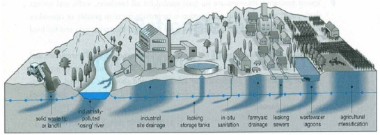
Groundwater resources that are increasingly being cherished for most socioeconomic development are exposed to varied pollutant sources. Studies have shown that they are vulnerable to various impacts such as climatic change, human impacts and also pollution from seawater intrusion in coastal areas. The susceptibility of a groundwater body to pollution indicates extent to which its quality is at risk of being compromised by contaminants. Assessments of this vulnerability are classified based on scale (site, local, regional) or objective (such as risk management or protection zoning) and also distinguish between source and resource vulnerability maps, as well as specific and intrinsic vulnerability maps. Groundwater vulnerability assessment methods differ based on several factors, including the availability and spatial distribution of quantitative and qualitative data, the objectives and scale of the mapping, the costs of model development, and the particular hydrogeological characteristics of the aquifer under investigation. The National Research Council has classified these methods into three primary categories: process-based methods, statistical methods, and overlay/index methods. Among these, the overlay/index method is widely employed for conducting large-scale assessments of aquifer sensitivity and groundwater vulnerability. It is especially advantageous in developing countries due to the easily accessible data required for its implementation.
| Published in | American Journal of Environmental Protection (Volume 13, Issue 4) |
| DOI | 10.11648/j.ajep.20241304.12 |
| Page(s) | 93-107 |
| Creative Commons |
This is an Open Access article, distributed under the terms of the Creative Commons Attribution 4.0 International License (http://creativecommons.org/licenses/by/4.0/), which permits unrestricted use, distribution and reproduction in any medium or format, provided the original work is properly cited. |
| Copyright |
Copyright © The Author(s), 2024. Published by Science Publishing Group |
Statistical Methods, Process-Based Methods, Hydrogeological Setting, Overlay/Index Method, Sea-Water Intrusion
Layer | Range | Rating | Typical rating | Weight |
|---|---|---|---|---|
Depth to water (m) | 0–1.5 | 10 | 5 | |
1.5–4.5 | 9 | |||
4.5–9 | 7 | |||
9–15 | 5 | |||
15–22.5 | 3 | |||
22.5–30 | 2 | |||
˃ 30 | 1 | |||
Recharge (mm/y) | ˃ 254 | 9 | 4 | |
178–254 | 8 | |||
102–178 | 6 | |||
51–102 | 3 | |||
0–51 | 1 | |||
Aquifer media | Karst limestone | 9–10 | 10 | 3 |
Basalt | 2–10 | 9 | ||
Sand and gravel | 4–9 | 8 | ||
Massive limestone | 4–9 | 6 | ||
Massive sandstone | 4–9 | 6 | ||
Bedded sandstone, limestone and shale sequences | 5–9 | 6 | ||
Glacial till | 4–6 | 5 | ||
Weathered metamorphic/igneous | 3–5 | 4 | ||
Metamorphic/igneous | 2–5 | 3 | ||
Massive shale | 1–3 | 2 | ||
Soil media | Thin or absent | 10 | 1 | |
Gravel | 10 | |||
Sand | 9 | |||
Peat | 8 | |||
Shrinking and/or aggregated clay | 7 | |||
Sandy loam | 6 | |||
Loam | 5 | |||
Silty loam | 4 | |||
Clay loam | 3 | |||
Muck | 2 | |||
Non-shrinking and non-aggregated clay | 1 | |||
Topography (%) | 0–2 | 10 | 1 | |
2–6 | 9 | |||
6–12 | 5 | |||
12–18 | 3 | |||
˃ 18 | 1 | |||
Impact of vadose zone | Karst limestone | 8–10 | 10 | 5 |
Basalt | 2–10 | 9 | ||
Sand and gravel | 6–9 | 8 | ||
Metamorphic/igneous | 2–8 | 4 | ||
Sand and gravel with significant silt | 4–8 | 6 | ||
Bedded sandstone, limestone and shale | 4–8 | 6 | ||
Sandstone | 4–8 | 6 | ||
Limestone | 2–7 | 6 | ||
Shale | 2–5 | 3 | ||
Silt/clay | 2–6 | 3 | ||
Confining layer | 1 | 1 | ||
Hydraulic conductivity (m/day) | ˃ 82 | 10 | 3 | |
41–82 | 8 | |||
29–41 | 6 | |||
12–29 | 4 | |||
4–12 | 2 | |||
<4 | 1 |
Indicators | Weight | Indicator Variables | Importance rating | |
|---|---|---|---|---|
Class | Range | |||
Groundwater occurrence/ Aquifer type | 1 | Confined Aquifer | 10 | |
Unconfined Aquifer | 7.5 | |||
Leaky confined Aquifer | 5 | |||
Bounded Aquifer (recharge and/or impervious boundary aligned parallel to the coast) | 2.5 | |||
Aquifer Hydraulic Conductivity (m/day) | 3 | High | ˃ 40 | 10 |
Medium | 10 – 40 | 7.5 | ||
Low | 5 – 10 | 5 | ||
Very low | ˂ 5 | 2.5 | ||
Height of groundwater Level above msl (m) Distance | 4 | High | ˂ 1.0 | 10 |
Medium | 1.0 – 1.5 | 7.5 | ||
Low | 1.5 – 2.0 | 5 | ||
Very low | ˃ 2.0 | 2.5 | ||
Distance from shore / High Tide (m) | 4 | High | ˂ 500 | 10 |
Medium | 500 – 750 | 7.5 | ||
Low | 750 – 1000 | 5 | ||
Very low | ˃ 1000 | 2.5 | ||
Impact of existing seawater intrusion | 1 | High | ˃ 2 | 10 |
Medium | 1.5 – 2.0 | 7.5 | ||
Low | 1 – 1.5 | 5 | ||
Very low | ˂ 1 | 2.5 | ||
Aquifer thickness (saturated) in meters | 2 | Large | ˃ 10 | 10 |
Medium | 7.5 – 10 | 7.5 | ||
Small | 5 – 7.5 | 5 | ||
Very small | ˂ 5 | 2.5 | ||
AVI | Aquifer Vulnerability Index |
GIS | Geographic Information System |
GOD | Groundwater Occurrence, Overlying Materials, and Depth to Water Table |
USA | United States of America |
| [1] | Barbulescu, A. J. W, “Assessing groundwater vulnerability: DRASTIC and DRASTIC Like Methods: A review.,” Water, vol. 12, no. 5, p. 1356, 2020, |
| [2] | Kaur R., and Rosin, K. G, “Ground Water Vulnerability Assessment: Challenges and Opportunities,” Div. Environ. Sci. Indian Agric. Res. Institute, New Delhi-110012, India., vol. 24, no. 4, pp. 82–92, 2012, [Online]. Available: http://www.cgwb.gov.in/documents/papers/incidpapers/Paper 12- R. Kaur.pdf |
| [3] | Wada, Y., Flörke, M., Hanasaki, N., Eisner, S., Fischer, G., Tramberend, S., Satoh, Y., Van Vliet, M. T. H., Yillia, P., and Ringler, C, “Modelling global water use for the 21st century: The Water Futures and Solutions (WFaS) initiative and its approaches,” Geosci. Model Dev., vol. 8, no. 8, pp. 175–22, 2016, |
| [4] | (United Nations World Water AssessmentProgramme)/ UN-Water WWAP, “The United Nations World Water Development Report 2018: Nature-Based Solutions for Water; UNESCO: Paris, France,” 2018. |
| [5] | (United Nations World Water Assessment Programme) WWAP, “The United Nations World Water Development Report 2014: Water and Energy; UNESCO: Paris, France,” 2014. |
| [6] | Mufur M. A., Awah, M. T., Nono, G. D. K., Tamfuh, P. A., Wotchoko, P., Adoh, M., and Kabeyene, V. B. K, “Assessment of Groundwater Quality for Domestic and Irrigation Purposes in Northern Bamenda (Cameroon),” J. Water Resour. Prot., vol. 13, no. 01, pp. 1–19, 2021, |
| [7] | Mache J. R., Signing, P., Njoya, A., Kunyukubundo, F., Mbey, J. A., Njopwouo, D., Fagel, N. “Smectite clay from the Sabga deposit (Cameroon): mineralogical and physicochemical properties.,” Clay Miner., vol. 48, no. 3, pp. 499–512, 2013, |
| [8] |
Morris, B. L., Lawrence, A. R. L., Chilton, P. J. C., Adams, B., Calow, R. C., and Klinck, B. A, Groundwater and its Susceptibility to Degradation: A Global Assessment of the Problem and Options for Management. Early Warning and Assessment Report Series, RS. 03-3. United Nations Environment Programme, Nairobi, Kenya. 2003.
http://www.unep.org/DEWA/water/groundwater/pdfs/Groundwater_INC_cover.pdf |
| [9] | Moges S. S., and Dinka, M. O, “Assessment of groundwater vulnerability mapping methods for sustainable water resource management: An overview,” J. Water L. Dev., vol. 52, no. I–III, pp. 186–198, 2022, |
| [10] | Margat, J, “Groundwater Vulnerability to Contamination,” Catography bases, 68 SGC 198 HYD, BRGM, Orleans, Fr., 1968. |
| [11] | Albinet, M., and Margat, J, “Groundwater Pollution Vulnerability Mapping,” Bull. du Bur. Res. Geol. Minieres Bull BGRM 2nd Ser., vol. 3, pp. 13–22, 1970. |
| [12] | Saheed, A. O, Aquifers: Properties, Roles and Research. 2017. |
| [13] | Gogu, R., and Dassargues, A, “Current trends and future challenges in groundwater vulnerability assessment using overlay and index methods,” Environ. Earth Sci., vol. 39, no. 6, pp. 549–562, 2000, |
| [14] | Sinan, M., Maslouhi, R., and Razack, M, Use of GIS for characterizing vulnerability to groundwater pollution. Application to groundwater of Haouz in Marrakech, Maroc. 2003. |
| [15] | Murhula, E., Kutangila, S., Birhenjira, E., and Muyisa, S, “Hydrogeochemistry and susceptibility to groundwater contamination in the Panzi sector (Bukavu City, DR Congo).,” Geo. Eco. Trop., vol. 43, no. 1, pp. 197–209, 2019. |
| [16] | Mbuluyo, M., Mashauri, F., and M’putu, P, “Mapping the vulnerability to pollution of the Isiro groundwater (North-eastern DR Congo) using DRASTIC method,” Africa Dev., vol. 13, no. 3, pp. 125–139, 2017. |
| [17] | Duijvenbooden, W., and Waegeningh, H. G,“Vulnerability of Soil and Groundwater to Pollutants.,” in Proceedings of the International Conference on Vulnerability of Soil and Groundwater to Pollutants, Delft, The Netherlands., 1987, p. 12. |
| [18] | Lobo-Ferreira J. P., and Cabral, M, Proposal for an operational definition of vulnerability for the European Community’s Atlas of Groundwater Resources. In: Meeting of the European Institute for Water, Groundwater Work Group Brussels. 1991, |
| [19] | Foster, S. S. D, “Groundwater recharge and pollution vulnerability of British aquifers: a critical overview.,” Geol. Soc. London, Spec. Publ., vol. 130, no. 1, pp. 7–22, 1998. |
| [20] | Tilahun K., and Merkel, B. J, “Assessment of groundwater vulnerability to pollution in Dire Dawa, Ethiopia using DRASTIC.,” Environ. Earth Sci., vol. 59, no. 7, pp. 1485–1496, 2010, |
| [21] | Ribeiro, L., Pindo, J. C., and Dominguez-Granda, L, “Assessment of groundwater vulnerability in the Daule aquifer, Ecuador, using the susceptibility index method.,” Sci. Total Environ., vol. 574, no. 3, pp. 1674–1683, 2017, |
| [22] | Aydi, A, “Evaluation of groundwater vulnerability to pollution using a GIS-based multi-criteria decision analysis.,” Groundw. Sustain. Dev., vol. 7, pp. 204–211, 2018, |
| [23] | NRC, Groundwater Vulnerability Assessment: Predicting Relative Contamination Potential Under Conditions of Uncertainty., Committee. Washington DC: The National Academies Press, 1993. |
| [24] | Simunek, J., Jarvis, N., and Van Genuchten, A., and Gärdenäs, M. T. h, “Review and comparison of models for describing non-equilibrium and preferential flow and transport in the unsaturated zone.,” J. Hydrol., vol. 272, no. 2003, pp. 14–35, 2003. |
| [25] | McDonald M., and Harbaugh, A, A Modular three dimensional finite difference ground-water flow model Techniques of Water-Resources Investigations of the U. S. Geological Survey. 1988. |
| [26] | Kouli, M., Lydakis-Simantiris, N., and Soupios, P, GIS-based aquifer modeling and planning using integrated geoenvironmental and chemical approaches. Groundwater: Modelling, Management Nova Science Publishers, Inc., 2008. |
| [27] | Lindström, R, “A system for modelling groundwater contamination in water supply areas – chloride contamination from road de-icing as an example.,” J. Nord. Hydrol., vol. 37, pp. 41–51, 2006, |
| [28] | Barbash J., and Resek, E, Pesticides in Groundwater: Distribution, Trends and Governing Factors. Chelsea, MI, Ann Arbor., 2nd ed. CRC Press, 1997. |
| [29] | Evans T., and Maidment, D, A spatial and statistical assessment of the vulnerability of texas groundwater to nitrate contamination (CRWR Online Report 95-2). Center for research in water resources, Bureau of Engineering Research. The University of Texas at Austin, 1995, |
| [30] | Worrall F., and Kolpin, D. W, “Aquifer vulnerability to pesticide pollution – combining soil, land-use and aquifer properties with molecular descriptors.,” J. Hydrol., vol. 293, no. 1–4, pp. 191–204, 2004, |
| [31] | Focazio M. J., Reilly, T. E., Rupert, M. G., and Helsel, D. R, “A national reconnaissance for pharmaceuticals and other organic wastewater contaminants in the United States – II) untreated drinking water sources.,” Sci. Total Environ., vol. 402, no. 2–3, pp. 201–216, 2008. |
| [32] | Wachniew P., Zurek, A. J., Stumpp, C., Gemitzi, A., Gargini, A., Filippini, M., Rozanski, K., Meeks, J., Kvaener, J., and Witczak, S, “Toward operational methods for the assessment of intrinsic groundwater vulnerability: A review.,” Crit. Rev. Environ. Sci. Technol., vol. 46, no. 8, pp. 827–884, 2016, |
| [33] |
Aller, L., Bennett, T., Lehr, J., Petty, R., and Hackett, G, “DRASTIC: a standardized system for evaluating groundwater pollution potential using hydrogeologic settings,” J. Geol. Soc. India, vol. 26, no. 1, pp. 23–37, 1987, [Online]. Available:
http://www.geoscindia.org/index.php/jgsi/article/view/73340%3E |
| [34] | Foster, S, Fundamental Concepts in Aquifer Vulnerability, Pollution Risk and Pro- tection Strategy. In: Van Duijvenbooden, W. and Van Waegeningh, H. G., Eds., Vulnerabil ity of Soil and Groundwater to Pollutants. 1987. |
| [35] | Stempvoort, D., Ewert, L., and Wassenaar, L, “Aquifer vulnerability index: A GIS-compatible method for groundwater vulnerability mapping.,” Can. Water Resour. Journal., vol. 18, no. 1, pp. 25–37, 1993, |
| [36] | Busico, G., Kazakis, Mastrocicco, C. N. M., Voudouris, K., and Tedesco, D, “A modified SINTACS method for groundwater vulnerability and pollution risk assessment in highly anthropized regions based on NO3– and SO42– concentrations.,” Sci. Total Environ., vol. 609, pp. 1512–1523, 2017, |
| [37] | Civita, M, Maps of the vulnerability of aquifers to pollution: Theory & Practice. Pythagoras Publishing, Bologna. 1994. |
| [38] | Chachadi, A., and Lobo Ferreira, J, “Seawater intrusion vulnerability mapping of aquifers using the GALDIT method. COASTIN - A Coastal Policy Research Newsletter.,” in Proceedings of the Workshop on Modelling in Hydrogeology, Anna University, Chennai., 2001, pp. 143–156. |
| [39] | Jang, W. S., Engel, B., Harbor, J., and Theller, L, “Aquifer vulnerability assessment for sustainable groundwater management using DRASTIC.,” Water, vol. 9, no. 10, p. 792, 2017, |
| [40] | Jawed, I., Gorai, A., Poonam, T., and Gopal, P, “Approaches to groundwater vulnerability to pollution: a literature review.,” Asian J. Water, Environ. Pollut., vol. 9, no. 1, pp. 105–115, 2012. |
| [41] | An Y., and Lu, W, “Assessment of groundwater quality and groundwater vulnerability in the northern Ordos Cretaceous Basin, China.,” Arab. J. Geosci., vol. 11, p. 118, 2018, |
| [42] | Kihumba, A. M., Vanclooster, M., and Longo, J. N, “Assessing ground-water vulnerability in the Kinshasa region, DR Congo, using a calibrated DRASTIC model.,” J. African Earth Sci., vol. 126, pp. 13–22, 2017, |
| [43] | Khosravi K., Sartaj, J. M., Tsai, F. T., Singh, V. P., Kazakis, N., Melesse, A. M., Prakash, I., Tien Bui, D., and Pham, B. T, “A comparison study of DRASTIC methods with various objective methods for ground-water vulnerability assessment.,” Sci. Total Environ-ment, vol. 642, pp. 1032–1049, 2018, |
| [44] | Panagopoulos, G. P., Lambrakis, N. J., and Antonakos, A. K, “Optimization of the DRASTIC method for groundwater vulnerability assessment via the use of simple statistical methods and GIS,” Hydrogeol. J., vol. 14, Feb. 2006, |
| [45] | Wei, A., Bi, P., Guo, J., Lu, S., and Li, D, “Modified DRASTIC model for groundwater vulnerability to nitrate contamination in the Dagujiaasin, China.,” Water Supply, vol. 21, no. 4, pp. 1793–1805, 2021, |
| [46] | Victorine Neh, A., Ako Ako, A., Richard Ayuk, A., and Hosono, T, “DRASTIC-GIS model for assessing vulnerability to pollution of the phreatic aquiferous formations in Douala-Cameroon,” J. African Earth Sci., vol. 102, pp. 180–190, 2015, |
| [47] |
Abdullah, T., Salahalddin, S., Al-Ansari, N. A., and Knutsson, S, Groundwater Vulnerability Using DRASTIC model Applied to Halabja Saidsadiq Basin, IRAQ. 2017. [Online]. Available:
https://www.diva-portal.org/smash/record.jsf?pid=diva2:1070726 |
| [48] | Mfonka, Z., Ndam Ngoupayou, J. R., Kpoumie, A., Ndjigui, P. D., Zammouri, M., Ngouh, A. N., Mouncherou, O. F. Mfochive, O. F., and Rakotondrabe, F, “Hydrodynamic and groundwater vulnerability assessment of the shallow aquifer of the Foumban locality (Bamoun plateau, Western-Cameroon),” Arab. J. Geosci., vol. 12, no. 5, 2019, |
| [49] | Ducci D., and Sellerino, M, “A Modified AVI Model for Groundwater Vulnerability Mapping: Case Studies in Southern Italy,” Water (Switzerland), vol. 14, no. 2, 2022, |
| [50] | Patel, P., Mehta, D., and Sharma, N, “A review on the application of the DRASTIC method in the assessment of groundwater vulnerability,” Water Supply, vol. 22, no. 5, pp. 5190–5205, 2022, |
| [51] | Civita, M, “The vulnerability evaluation of aquifers to pollution.,” in Proc 1st Con. Nat. “Protection and Management of Groundwater: Methodologies, Technologies and Objectives’’, Marano sul Panaro.,” 1990, pp. 39–86. |
| [52] | Civita, M., De Maio, M., and Vigna, B, “A GIS Methodology for evaluation active aquifer recharge.,” in Proceedings of the 3rd nationalist convention on the protection and management of groundwater in the third millennium. Papers of applied geology., 1999, pp. 291–303. |
| [53] | Kuisi, M. A., El-Naqa, A., and Hammouri, N, “Vulnerability mapping of shallow groundwater aquifer using SINTACS model in the Jordan Valley area, Jordan.,” Environ. Geol., vol. 50, no. 5, pp. 651–667, 2006, |
| [54] | Civita, M, “The combined approach when assessing and mapping groundwater vulnerability to contamination.,” J. Water Resour. Prot., vol. 2, pp. 14–28, 2010. |
| [55] | Kumar, P., Bansod, B. K. S., Debnath, S. K., Thakur, P. K., and Ghansy, A. C, “Index-based groundwater vulnerability mapping models using hydrogeological settings: A critical evaluation.,” Environ. Impact Assess. Rev., vol. 51, pp. 38–49, 2015, |
| [56] | Jaunat J., Garel, E., Huneau, F., Erostate, M., Santoni, S., Robert, S., Fox, D., and Pasqualini, V, “Combinations of geoenvironmental data underline coastal aquifer anthropogenic nitrate legacy through groundwater vulnerability mapping methods.,” Sci. Total Environonment., vol. 658, pp. 1390–1403, 2019, |
| [57] | Pavlis, M., Cummins, E., and Mcdonnell, K, “Groundwater vulnerability assessment of plant protection products: A review.,” Ecol. Risk Assess. An Int. Journal., vol. 16, no. 3, pp. 621–650, 2010, |
| [58] | Aboulouafa, M., Taouil, H., Ibn Ahmed, S., Tairi, A., Arouya, K., and Hsaissoune, M, “SINTACS and DRASTIC Models for Groundwater Vulnerability Assessment and Mapping using a GIS and Remote sensing Techniques: a Case Study on Berrechid Plain,” IOSR J. Eng., vol. 07, no. 05, pp. 23–30, 2017, |
| [59] | Corniello, A., Ducci, D., and Monti, G, “Aquifer pollution vulnerability in the Sorrento Peninsula, Southern Italy, evaluated by SINTACS Method.,” Geofís. Int., vol. 43, pp. 575–581, 2004. |
| [60] | Draoui, M., Vias, J., Andreo, B., Targuisti, K., and El Messari, J, “A Comparative Study of Four Vulnerability Mapping Methods in a Detritic Aquifer under Mediterranean Climatic Conditions.,” Environ. Geol., vol. 54, pp. 455–463, 2008, |
| [61] | Kaddour, K., Houcine, B., and Smail, M, “Assessment of the vulnerability of an aquifer by DRASTIC and SYNTACS methods: Aquifer of Bazer—Geult Zerga area (northeast Algeria).,” Environ. Res. Manag., vol. 5, pp. 0169–0179, 2014. |
| [62] | Gogu, R., Pandele, A., Ionita, A., and Ionescu, C, “Groundwater vulnerability analysis using a low-cost Geographical Information System.,” in In Proceedings of the MIS/UDMS Conference WELL-GIS WORKSHOP’s Environmental Information Systems for Regional and and Municipal Planning, Prague, Czech Republic, 1996, pp. 35–49. |
| [63] | Secunda, S., Collin, M., and Melloul, A, “Groundwater Vulnerability Assessment Using a Composite Model Combining DRASTIC with Extensive Land Use in Israel’s Sharon Region.,” J. Environ. Manag., vol. 54, pp. 39–57, 1998, |
| [64] | Noori, R., Ghahremanzadeh, H., Kløve, B., Adamowski, F., and Baghvand, A, “Modified-DRASTIC, modified-SINTACS and SI methods for groundwater vulnerability assessment in the southern Tehran aquifer.,” J. Environ. Sci. Heal., vol. 54, pp. 89–91, 2019, |
| [65] | Sujitha, V., Purandara, B. K., Shivapur, A. V., and Davithuraj, J, “Assessment of Aquifer Vulnerability Using GALDIT Model — A Case Study,” J. Geol. Soc. India, vol. 95, no. 5, pp. 507–512, 2020, |
| [66] | Mirzavand, M., Ghasemieh, H., Sadatinejad, S. J., Bagheri, R., and Clark, I. D, “Saltwater intrusion vulnerability assessment using AHP-GALDIT model in Kashan plain aquifer as critical aquifer in a semi-arid region,” Desert, vol. 32, no. 2, pp. 255–264, 2018, |
| [67] | Yang, J. S., Jeong, Y. W., Agossou, A., Sohn, J. S., and Lee, J. B., “GALDIT Modification for Seasonal Seawater Intrusion Mapping Using Multi Criteria Decision Making Methods,” Water (Switzerland), vol. 14, no. 14, pp. 1–19, 2022, |
| [68] | Bordbar, M., Neshat, A., and Javadi, S, “Modification of the GALDIT framework using statistical and entropy models to assess coastal aquifer vulnerability.,” Hydrol. Sci. J., vol. 64, pp. 1117–1128, 2019. |
| [69] | Napolitano P., and Fabbri, A. G, Single-parameter sensitivity analysis for aquifer vulnerability assessment using DRASTIC and SINTACS. In: Application of Geographic Information Systems in Hydrology and Water Resources Management. IAHS Press, Institute of Hydrology, Wallingford, UK, 1996. |
| [70] | Babiker, I. S., Mohammed, M. A. A., Hiyama, T., and Kato, K, “A GIS-based DRASTIC model for assessing aquifer vulnerability in Kakamigahara Heights, Gifu Prefecture, central Japan.,” Sci. Total Environ., vol. 345, no. 1–3, pp. 127–140, 2005, |
| [71] | Lodwick, W. A., Monson, W., and Svoboda, L., “Attribute error and sensitivity analysis of map operations in geographical information’s systems: suitability analysis.,” Int. J. Geogr. Inf. Syst., vol. 4, no. 4, pp. 413–428, 1990, |
| [72] | Ganesh Babu, O., Sashikkumar, M. C., Saravanan, R., and Pitchaikani, S, “Drastic modeling for assessment of groundwater vulnerability to pollution,” Int. J. Earth Sci. Eng., vol. 9, no. 6, pp. 2878–2887, 2016. |
| [73] | Pacheco, F. A. L., Pires, L. M. G. R., Santos, R. M. B., and Sanchez Fernandes, L. F, “Factor weighting in DRASTIC modeling.,” Sci. Total Environ., vol. 505, pp. 474–486, 2015. |
| [74] | Yuan-Zheng, Z., Yuan-guo, T., Jin-sheng, W., and Huan, H, “Progress in Groundwater vulnerability Based on Process Simulation,” Bullletin Mineral. Petrol. Geochemistry, vol. 32, no. 1, pp. 122–126, 2013, |
| [75] | Dassargues, A., Popescu, C., and Brouyère, S, “Physically Based Groundwater Vulnerability Assessment Using Sensitivity Analysis Methods,” Groundwater, vol. 52, no. 6, pp. 864–874, 2014, |
| [76] | Geng C., Lu, D., Qian, J., Xu, C., Li, D., Ou, J., and Ye, Z, “A Review on Process-Based Groundwater Vulnerability Assessment Methods,” Processes, vol. 11, no. 6, 2023, |
| [77] | Burkart, M. R., Kolpin, D. W., and James, D. E, “Assessing groundwater vulnerability to agrichemical contamination in the Midwest US,” Water Sci. Technol., vol. 39, no. 3, pp. 103–112, 1999, |
| [78] | Machiwal, D., Cloutier, V., Güler, C., and Kazakis, N, “A review of GIS-integrated statistical techniques for groundwater quality evaluation and protection,” Environ. Earth Sci., vol. 77, no. 19, p. 0, 2018, |
| [79] | Fuchs, S., Heiser, M., Schlögl, M., Zischg, A., Papathoma-Köhle, M., and Keiler, M, “Short communication: A model to predict flood loss in mountain areas,” Environ. Model. Softw., vol. 117, no. March, pp. 176–180, 2019, |
| [80] | Reed W. R., and Zhu, M, “On estimating long-run effects in models with lagged dependent variables,” Econ. Model., vol. 64, no. December 2016, pp. 302–311, 2017, |
| [81] | Bonfanti, M., Ducci, D., Masetti, M., Sellerino, M., and Stevenazzi, S, “Using statistical analyses for improving rating methods for groundwater vulnerability in contamination maps,” Environ. Earth Sci., vol. 75, no. 12, 2016, |
| [82] | Stevenazzi, S., Bonfanti, M., Masetti, M., Nghiem, S. V., and Sorichetta, A, “A versatile method for groundwater vulnerability projections in future scenarios,” J. Environ. Manage., vol. 187, no. 2017, pp. 365–374, 2017, |
| [83] | Thapa, R., Gupta, S., Guin, S., and Kaur, H, “Sensitivity analysis and mapping the potential groundwater vulnerability zones in Birbhum district, India: A comparative approach between vulnerability models,” Water Sci., vol. 32, no. 1, pp. 44–66, 2018, |
| [84] | Boufekane A., and Saighi, O, “Application of Groundwater Vulnerability Overlay and Index Methods to the Jijel Plain Area (Algeria),” Groundwater, vol. 56, no. 1, pp. 143–156, 2018, |
| [85] | Goyal, D., Haritash, A. K., and Singh, S. K, “A comprehensive review of groundwater vulnerability assessment using index-based, modelling and coupling methods,” J. Environ. Manage., vol. 296, no. March, p. 113161, 2021, |
| [86] | Fiori, A., Pomarico, I., Zarlenga, A., Catani, V., and Leone, G, “Extending the Overlay and Index: A Simple Method for Assessing Aquifer Vulnerability in a Combined Vadose Zone—Groundwater Flow System,” Water (Switzerland), vol. 15, no. 2, 2023, |
APA Style
Aduck, J. N., Mufur, A. M., Fonteh, M. F. (2024). A Review of Methods to Assess Groundwater Vulnerability to Pollution. American Journal of Environmental Protection, 13(4), 93-107. https://doi.org/10.11648/j.ajep.20241304.12
ACS Style
Aduck, J. N.; Mufur, A. M.; Fonteh, M. F. A Review of Methods to Assess Groundwater Vulnerability to Pollution. Am. J. Environ. Prot. 2024, 13(4), 93-107. doi: 10.11648/j.ajep.20241304.12
AMA Style
Aduck JN, Mufur AM, Fonteh MF. A Review of Methods to Assess Groundwater Vulnerability to Pollution. Am J Environ Prot. 2024;13(4):93-107. doi: 10.11648/j.ajep.20241304.12
@article{10.11648/j.ajep.20241304.12,
  author = {Jovens Nyangang Aduck and Alice Magha Mufur and Mathias Fru Fonteh},
  title = {A Review of Methods to Assess Groundwater Vulnerability to Pollution
},
  journal = {American Journal of Environmental Protection},
  volume = {13},
  number = {4},
  pages = {93-107},
  doi = {10.11648/j.ajep.20241304.12},
  url = {https://doi.org/10.11648/j.ajep.20241304.12},
  eprint = {https://article.sciencepublishinggroup.com/pdf/10.11648.j.ajep.20241304.12},
  abstract = {Groundwater resources that are increasingly being cherished for most socioeconomic development are exposed to varied pollutant sources. Studies have shown that they are vulnerable to various impacts such as climatic change, human impacts and also pollution from seawater intrusion in coastal areas. The susceptibility of a groundwater body to pollution indicates extent to which its quality is at risk of being compromised by contaminants. Assessments of this vulnerability are classified based on scale (site, local, regional) or objective (such as risk management or protection zoning) and also distinguish between source and resource vulnerability maps, as well as specific and intrinsic vulnerability maps. Groundwater vulnerability assessment methods differ based on several factors, including the availability and spatial distribution of quantitative and qualitative data, the objectives and scale of the mapping, the costs of model development, and the particular hydrogeological characteristics of the aquifer under investigation. The National Research Council has classified these methods into three primary categories: process-based methods, statistical methods, and overlay/index methods. Among these, the overlay/index method is widely employed for conducting large-scale assessments of aquifer sensitivity and groundwater vulnerability. It is especially advantageous in developing countries due to the easily accessible data required for its implementation.
},
 year = {2024}
}
TY  - JOUR
T1  - A Review of Methods to Assess Groundwater Vulnerability to Pollution

AU  - Jovens Nyangang Aduck
AU  - Alice Magha Mufur
AU  - Mathias Fru Fonteh
Y1  - 2024/09/11
PY  - 2024
N1  - https://doi.org/10.11648/j.ajep.20241304.12
DO  - 10.11648/j.ajep.20241304.12
T2  - American Journal of Environmental Protection
JF  - American Journal of Environmental Protection
JO  - American Journal of Environmental Protection
SP  - 93
EP  - 107
PB  - Science Publishing Group
SN  - 2328-5699
UR  - https://doi.org/10.11648/j.ajep.20241304.12
AB  - Groundwater resources that are increasingly being cherished for most socioeconomic development are exposed to varied pollutant sources. Studies have shown that they are vulnerable to various impacts such as climatic change, human impacts and also pollution from seawater intrusion in coastal areas. The susceptibility of a groundwater body to pollution indicates extent to which its quality is at risk of being compromised by contaminants. Assessments of this vulnerability are classified based on scale (site, local, regional) or objective (such as risk management or protection zoning) and also distinguish between source and resource vulnerability maps, as well as specific and intrinsic vulnerability maps. Groundwater vulnerability assessment methods differ based on several factors, including the availability and spatial distribution of quantitative and qualitative data, the objectives and scale of the mapping, the costs of model development, and the particular hydrogeological characteristics of the aquifer under investigation. The National Research Council has classified these methods into three primary categories: process-based methods, statistical methods, and overlay/index methods. Among these, the overlay/index method is widely employed for conducting large-scale assessments of aquifer sensitivity and groundwater vulnerability. It is especially advantageous in developing countries due to the easily accessible data required for its implementation.

VL  - 13
IS  - 4
ER  -
Department of Agricultural and Environmental Engineering, College of Technology, The University of Bamenda, Bamenda, Cameroon
Research Fields: Hydrogeology, Hydrogeochemistry, Water Resources Management , Hydrology, Applied Geology
Department of Agricultural and Environmental Engineering, College of Technology, The University of Bamenda, Bamenda, Cameroon; Department of Geology, Higher Teacher Training College, The University of Bamenda, Bamenda, Cameroon
Research Fields: Hydrogeochemistry, Hydrogeology, Hydrology, Water Resources Management, Environmental Pollution
Department of Agricultural and Environmental Engineering, College of Technology, The University of Bamenda, Bamenda, Cameroon
Research Fields: Water Resources Management, Rainwater Harvesting, Irrigation Engineering, Integrated Water Resources Management, Evapotranspiration, Agricultural Engineering
Information