Abstract
The earthwork estimation has a huge impact on the construction cost of the road. Therefore, the initial road design relies on precise terrain modeling. In this context, a low cost data offered by Digital Elevation Models (DEMs) are introduced. This study assessed the performances of three freely available DEMs; ALOS, SRTM and ASTER in flat, rolling and mountainous terrain for road design. Digital Elevation Models (DEMs) are helpful for estimating cut-and-fill volumes in a road construction project. Not being accurate can cost too much. This study aims to examine the accuracy of DEMs by comparing them with field survey data and their suitability for earthwork estimation in various terrain conditions. The study used statistical methods for error Analysis like Root mean square error calculations. Elevation profile and percentage error for comparison between DEM data versus reference ground survey data. The cut-and-fill volumes were estimated using TIN surfaces created from each DEM and the actual surveyed estimates were compared. The study found that the most accurate DEM was from ALOS with RMSE value for flat terrain, rolling terrain and mountainous terrain being 4.89 m, 5.14 m and 27.96 m respectively. The heights recorded by SRTM were relatively better with RMSE of 5.02 m, 5.47 m and 29.75 m whereas those from ASTER were the worst with RMSE of 9.15 m, 8.51 m and 30.51 m. The percentage errors in earthwork estimations for cut volumes recorded using ALOS were the lowest 21.28% (flat), 15.64% (rolling) and 47.93% (mountainous) while those of ASTER were 42.45%, 47.33% and 55.20% respectively and STRM were 31.28%, 36.26% and 47.43%. The study found that ALOS produces the best elevation and earthwork estimates, compared to SRTM and ASTER. ALOS is a very accurate sensor with very high accuracy on flat and rolling terrains and reduced accuracy on all models in mountainous terrain. ALOS is so effective that using them could help improve the cost estimation significantly and lessen the uncertainty of money in the road construction. In the future, scientists should work on dealing ALOS data with other sets of geospatial data. Also, a cost-benefit analysis of ALOS-based models in large-scale infrastructure projects can help us understand its application better.
Keywords
Advanced Land Observing Satellite, Advanced Spaceborne Thermal Emission and Reflection Radiometer, Digital Elevation Model, Earthwork Estimation, Shuttle Radar Topography Mission
1. Introduction
1.1. Background
A digital elevation model (DEM) is a two-dimensional (2D) raster file that uses terrain elevations for ground positions at regularly spaced horizontal intervals to create a three-dimensional (3D) computer representation of ground surface topography or relief
| [1] | K. S. J. &. A. A. Aruga, "Application of an airborne laser scanner to forest road design with accurate earthwork volumes", Journal of Forest Research, pp. 10, 113-123, 2005. |
[1]
. The most important and fundamental data source for a range of earth observation platforms that offer the fundamental information needed to describe the topographic features of terrain are DEM-derived topographic parameters like slope, aspect, and curvature Since the development of spatial numerical computer-based models and Geospatial Information Systems (GIS), DEM data have grown in popularity
| [2] | T. a. S. J. Blaschke, "Defining Landscape Units through Integrated Morphometric Characteristics. In: Buhmann, E. and Ervin, S., Eds., Landscape In: Buhmann, E. and Ervin, S., Eds., Landscape", Digital Techniques for Landscape Architecture, Wichmann-Verlag, Heidelberg, pp. 104-113, 2003. |
| [3] | M. A. P. &. C. W. Contreras, "Improving Accuracy in Earthwork Volume Estimation for Proposed Forest Roads Using a High-Resolution Digital Elevation Model", Croatian Journal of Forest Engineering: Journal for Theory and Application of Forestry Engineering, pp. 33, 125-142, 2012. |
[2, 3]
. DEMs have emerged as a crucial and effective technique for mapping and predicting geohazards: landslide susceptibility mapping, land subsidence mapping, and flood inundation mapping an overview of the use of DEM in biological, hydrological, and geomorphologic modeling applications may be found in DEMs are being generated using a wide range of techniques
| [4] | P. &. T. N. Fisher, "Causes and consequences of error in digital elevation models", Progress in Physical Geography, pp. 30, 467-489, 2006. |
[4]
. Contour lines from topographic maps can be used to interpolate it.
Digital DEMs produced with these methods are available at a variety of resolutions
| [5] | J. B. A. M. M. &. B. X. Goetz, "Modeling the precision of structure-from-motion multi-view stereo digital elevation models from repeated close-range aerial surveys", Remote Sensing of Environment, 2018. |
[5]
. But in a lot of developing nations, the only places to find DEMs are freely available online.
| [6] | P. N. A. G. C. M. J. H. L. F. I. G. D. R. H. H.-C. V. R. S. L.-V. C. C. C. A. C. &. S. P. Guth, "Guth, P., Niekerk, A., Grohmann, C., Muller, J., Hawker, L., Florinsky, I., Gesch, D., Reuter, H., Herrera-Cruz, V., Riazanoff, S., López-Vázquez, C., Carabajal, C., Albinet, C., & Strobl, P.", Remote. Sens, 13, 3581, 2021. |
[6]
. Two methods and their outcomes will be contrasted in this study with precise heights derived from spot height points gathered from measurements made by terrestrial surveying
| [7] | W. Ha, "Applications of 3D Visualization in Road Profile Design and Earthwork Calculation", Surveying and Mapping of Geology and Mineral Resources, 2015. |
| [8] | J. &. H. M. Höhle, "Accuracy assessment of digital elevation models by means of robust statistical methods", Isprs Journal of Photogrammetry and Remote Sensing, pp. 64, 398-406, 2009. |
[7, 8]
. The most recent Advanced Space-borne Thermal Emission Reflect meter DEM (ASTER GDEM2) and Shuttle Radar Topography Mission (SRTM) DEMs released by the Consortium for Spatial Information (SRTM CGIAR-CSI version 4.1) and the United States Geological Survey (SRTM3 USGS version 2.1) served as the basis for the DEM extraction
| [9] | M. &. Z. N. Zhao, "Method for the Construction of Urban Road Digital Elevation Models Integrated with Semantic Information", Applied Sciences, 2023. |
[9]
.
One of the world's most comprehensive high-resolution digital topographic data sets to date was produced by the Shuttle Radar Topography Mission (SRTM). Using two antenna pairs operating in the C- and X-bands, SRTM collected synthetic aperture radar (SAR) interferometry (InSAR) while simultaneously lighting up the earth's surface and recording backscattered radar signals aboard the Shuttle Endeavour.
| [9] | M. &. Z. N. Zhao, "Method for the Construction of Urban Road Digital Elevation Models Integrated with Semantic Information", Applied Sciences, 2023. |
[9]
. The Jet Propulsion Laboratory (JPL) has used this data to create a near-global topography data product for the earth's surface between latitudes 60 N and 57 S
| [10] | L. Yu, "Earthwork Optimal Allocation Model of Road Engineering Based on BIM Technology", Proceedings of the 2022 2nd International Conference on Control and Intelligent Robotics, 2022. |
[10]
.
The SRTM DEM (henceforth referred to as SRTM) has undergone multiple improvements since its original release in 2003, with Version 4 being the most current
| [11] | S. C. Y. Y. F. &. M. M. Yao, "A continuous digital elevation representation model for DEM super-resolution", ISPRS Journal of Photogrammetry and Remote Sensing, 2024. |
| [12] | E. A. S. M. B. M. M. &. K. A. Uuemaa, "Vertical Accuracy of Freely Available Global Digital Elevation Models (ASTER, AW3D30, MERIT, TanDEM-X, SRTM, and NASADEM)", Remote. Sens, 12, 3482, 2020. |
[11, 12]
. According to reports, the vertical inaccuracy of SRTM Version 4, which has a ground resolution of 3 arcsec (about 90 m × 90 m), is less than 16 m at a 90% confidence level. Since the availability of SRTM data, its vertical precision of roughly 15 m or better on 30 m geographic cells has made them appealing for a variety of applications
| [13] | S. G. R. a. G. A. Snehmani, " Extraction of High Resolution", Journal of Remote Sensing and GIS (JORSG), pp. 4, 23-34, 2013. |
[13]
.
1.2. Statement of the Problem
For route selection purposes it is common practice in Ethiopia to utilize free to download satellite SRTM or ASTER data in conjunction with road design software to develop a nominal alignment for each option. This allows an approximation to be made regarding route length and earthworks quantities. At route selection stage, ERA design manual requires a road construction costs should be estimated to within 30% of the final design figure. In order to achieve this, the initial route alignments and quantities need to be as accurate as possible. According to ERA's past studies, comparison of cut and fill quantities using SRTM data with those determined in a design that utilized topographic survey data in ‘flat’ terrain, found that those derived from satellite imagery were within 30% per cent of the design quantities. However, when this exercise was repeated for mountainous roads the earthwork quantities were only 40-50% of the actual quantities. Accordingly, ERA recommended the use of satellite imagery for flat terrain only.
1.3. General Objectives
The general objective of this study is to compare the vertical accuracy and practical applicability of SRTM Version 4.1 and ASTER GDEM Version 2 digital elevation models along the Ali Ethiopia–Deghamedo and Abala–Irepti road corridors, by using ground-surveyed elevation data as a reference, with the aim of assessing their reliability for road alignment planning and early-stage construction cost estimation in both flat and mountainous terrains.
1.4. Specific Objectives
1) Compare the vertical accuracy of SRTM and ASTER GDEM digital elevation models using ground-surveyed elevation data along two selected road corridors in Ethiopia.
2) Evaluate the performance of the two DEMs in estimating cut and fill volumes for road construction in both flat and mountainous terrains.
3) Assess the influence of DEM accuracy on preliminary road construction cost estimation during the route selection stage.
1.5. Scope of the Research
In this work, two Ethiopian road corridors—one in flat terrain and the other in mountainous terrain—are used to compare the vertical accuracy of SRTM and ASTER GDEM digital elevation models using ground-surveyed data. The models' applicability for early road design and cost estimation is evaluated using elevation error analysis, profile comparisons, and cut-and-fill volume estimation.
2. Materials and Research Methodology
2.1. Study Site
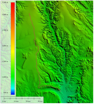
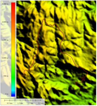
The study is conducted along two road corridor sites in Ethiopia. These sites fall in different terrain classification and have different elevation ranges. Road 1 has a total length of 100 km. the road starts at Ali Ethiopia (8° 45' 51.2074" N, 42° 24' 56.9074" E) and ends at 8° 06' 09.9842" N, 42° 39' 50.3261" E. It is part of Ali Ethiopia - Degehamedo Road Corridor which is found in south eastern part of the country in Ethiopia Somali region. The road alignment traverses in a fairly flat terrain, with an average slope of 1.57% and a maximum slope of 14.2%. Road 2 has a total length of 20 km. the road starts at 13° 16' 44.2887" N, 39° 56' 36.7683" E and ends at 13° 15' 48.9769" N, 39° 59' 46.6357" E. It is part of Abala - Irepti Road Corridor which is found in North eastern part of the country in Afar regional State. The alignment dominantly traverse in mountainous and escarpment terrain. The terrain that the road corridor crosses has an average slope of 8.13% and a maximum slope of 44.2%. These sites were deliberately chosen by reason of the fact that it presents different terrain conditions (flat and rugged mountainous sections) for purpose of conducting stastical analysis.
Figure 1. Ali Ethiopia - Deghamedo DEM, the red line shows the road center line.
Figure 2. Abala - Irepti DEM, the red line shows the road center line.
2.2. Comparison Methods
In order to describe and compare the Accuracy of elevation values of each DEM, DEM differencing was performed at first to derive elevation error maps. From a statistical point of view, the vertical accuracy of the two elevation data was assessed by computing the differences between the DEM extracted value and the corresponding reference elevation points. For each point, an elevation error was computed as the difference between explored and reference data Equation (
1):
(1)
In Equation (
1), Zerror is the elevation error, ZDEM is the elevation value of the DEM being explored, and Zrefrence is the corresponding reference elevation point value. Positive differences represent locations where the DEM elevation exceeded the reference elevation points; and, conversely, negative errors occur at locations where the DEM elevation was below the reverence elevation points.
| [14] | S. J. P. M. S. G. A. G. R. &. M. A. Mukherjee, "Evaluation of vertical accuracy of open source Digital Elevation Model (DEM)", Int. J. Appl. Earth Obs. Geoinformation, pp. 21, 205-217, 2013. |
| [15] | H. L. H. R. M. &. G. R. Liu, "Development of road grade data using the United States geological survey digital elevation model", Transportation Research Part C: Emerging Technologies, 2018. |
[14, 15]
After that, a common measure of quantifying vertical accuracy in DEMs, was calculated for each DEM’s errors among them the mean error (Mean error), maximum error (Maxerror), minimum error (Minimum error), standard deviation error (STD), Sample Variance (σ2), and root mean square error (RMSE) values were calculated as follows in Equations (
2-5).
STD =(3)
(5)
Correlation scatter plots were performed to assess the level of correlation between the DEMs values and reference elevation values. Two scatter plots were produced and correlation coefficient determined. correlation coefficient represents the association between two variables or the degree of co-variation of the two variables or the tendency of variable to vary together in the sense that one increases as the other increases (positive co-variation) or in the sense that one variable increases as the other decreases (negative co-variation). Longitudinal Profiles were extracted on the DEMs using the Global Mapper V16 at 5 m interval, along the road center line, and the data exported to excel for comparison. Profiles of the two DEMs were plotted and compared. Finally, relative accuracy of SRTM extracted TIN surface was compared with the reference TIN surface by computing the volume of cut and fill between the TIN surfaces and a relative road finished surfaces.
The relative accuracies of the studied DEMs have numerous implications for Topographical mapping along the road alignment and prediction of road construction costs at preliminary stages of road design projects. Ethiopian Roads Authority (ERA) Route selection Manual 2013, recommends the use of satellite imagery for topographical mapping at route selection stages of road design projects. ERA 2013 route selection manual also mentions that ASTER DEM is favored over SRTM by design consultants. To understand the implication of the accuracy of SRTM on prediction of the road construction cost, the study made comparison on calculated volume of cut and fill between the TIN surfaces and a relative finished road profile level designed using AutoCAD Civil 3d road design software.
3. Results and Discussions
Table 1 &
Table 2 shows the summary statistics for elevation errors of ASTER-GDEM ver.2 and SRTM ver.4.1 elevation errors over the study areas. The difference of the mean value (mean elevation difference) for the ASTER and SRTM elevations are -13.78 m, and +3.89 m, respectively for site 1 and 9.24 m and -3.18 m, respectively for site 2. For study site 1, the difference in the maximum values (highest elevation difference) for the ASTER and SRTM elevations are +11.45 m, and 8.37 and respectively, where the minimum values (lowest difference) for the ASTER and SRTM elevations are −42.97 m and −6.91 m respectively. For the study site 2, the difference in the maximum values (highest elevation difference) for the ASTER and SRTM elevations are +62.96 m, and 28.73 and respectively, where the minimum values (lowest difference) for the ASTER and SRTM elevations are −35.55 m and −26.51 m respectively The overall absolute vertical accuracy expressed as the vertical RMSE, which is the standard measure of DEM’s vertical accuracy taking into account both random and systematic errors introduced during the data generation process. It measures the difference between the values of the DEM elevations and the values of corresponding reference elevations. It is currently widely adopted mostly because it is a comprehensive statistic and because it is easy to implement
| [2] | T. a. S. J. Blaschke, "Defining Landscape Units through Integrated Morphometric Characteristics. In: Buhmann, E. and Ervin, S., Eds., Landscape In: Buhmann, E. and Ervin, S., Eds., Landscape", Digital Techniques for Landscape Architecture, Wichmann-Verlag, Heidelberg, pp. 104-113, 2003. |
[2]
. In this study, the RMSE of SRTM and ASTER DEM in relation to a reference DEM were calculated. For the study site 1, it is demonstrated that the vertical accuracy of ASTER GDEM2 in term of RMSE against reference elevation is 15.17 m, while for the SRTM v4.1 DEM the RMSE is 4.02 m against reference elevations. For the study site 2, the vertical accuracy of ASTER GDEM2 in term of RMSE against reference elevation is 15.04 m, while for the SRTM v4.1 DEM the RMSE is 7.43 m against reference elevations.
Table 1. Summary of statistics for Ali Ethiopia Road Corridor.
The summary statics for ASTER, SRTM elevation along the road corridor 1 |
STATSTICS | TOPO - ASTER | TOPO - SRTM |
Mean | - 13.78 (m) | + 3.89 (m) |
Standard Deviation | ±7.14 (m) | ±1.03 (m) |
Sample Variance | 51.05 (m2) | 1.06 (m2) |
Minimum | -42.97 (m) | -6.91 (m) |
Maximum | 11.45 | 8.37 |
Count | 26609 | 26609 |
RMSE | 15.17 | 4.02 |
Table 2. Summary of statistics for Abala road Corridor.
The summary statics for ASTER, SRTM elevation along the road corridor 2 |
STATSTICS | TOPO - ASTER | TOPO - SRTM |
Mean | - 13.78 (m) | - 3.18 (m) |
Standard Deviation | ±7.14 (m) | ±6.71 (m) |
Sample Variance | 51.05 (m2) | 45.06 (m2) |
Minimum | -42.97 (m) | -26.515 (m) |
Maximum | 11.45 | 28.729 |
Count | 26609 | 20179 |
RMSE | 15.17 | 7.43 |
Results are in agreement with the expected theoretical values achieved in previous studies. It was confirmed that the vertical accuracy of ASTER GDEM is 26 m (root mean square error (RMSE) against GPS-GCPs. Have attained the same estimated accuracy of GDEM for two different regions in western Germany and the Eastern Desert of Egypt. Further, investigated the total RMSE values of GDEM evaluated by over Istanbul are 20 m or better compared with the reference DEM generated from 1:5000 scaled topographic maps. On other hand, SRTM mission specifications, SRTM was estimated to generate DEMs with a vertical RMSE of 16 m equivalent vertical accuracy requirements for topographic data at scale 1:250,000. It is especially important for derivative products that make use of the local differences among adjacent elevation values, such as slope and aspect
| [1] | K. S. J. &. A. A. Aruga, "Application of an airborne laser scanner to forest road design with accurate earthwork volumes", Journal of Forest Research, pp. 10, 113-123, 2005. |
[1]
The values of standard deviation of SRTM and ASTER derived DEM difference are ±1.03 m, and ±7.14 m respectively for road corridor 1, ±6.71 m, and ±11.87 m respectively for the road corridor 2. Standard that meet the USA map accuracy standards.
The relative vertical accuracy is expressed as the standard deviation of the vertical error [deviation value illustrates the spread of elevation difference values around the mean error value for each study. The statistics show that ASTER error is more variable (wider spread) than for SRTM, the variance is sensitive to unusually high or low values, and smaller standard deviation and consequently smaller variance and consequently smaller variability. It is generally believed that ASTER is inconsistent comparing to SRTM, the higher the st.dev value, the more vertical accuracy diverse from place to another and it is affected by the stack number of stereo images and slope.
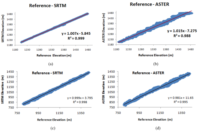
The correlation plots between reference elevation data and each of the DEMs obtained is shown in
Figure 3. As mentioned earlier, these plots are based on a selection of 26609 and 20179 reference elevation points for site 1 (Ali Ethiopia) and site 2 (Abala), respectively. Results illustrate that SRTM v4.1 data elevation values are slightly better correlated to the reference than ASTER for both study sites. Correlation coefficients are 0.988 and 0.999 for ASTER and SRTM v4.1, respectively for site 1 and 0.995 and 0.988 for ASTER and SRTM v4.1, respectively for site 2 all stations extend the line of perfect fit, showing excellent coefficient of correlation. This could be due to the large number of used points and well distribution of selected points.
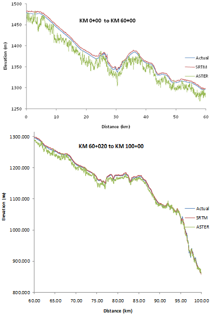
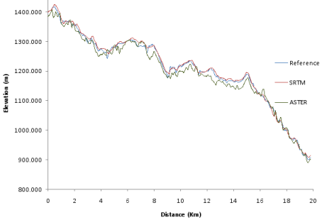
Additional. Assessment of DEM’s vertical accuracy is carry out by comparing the elevation profiles of the three DEMs plotted using Excel sheet. The profiles have been chosen to pass through the center line of the roads.
It can easily be observed that the profiles demonstrated similar trend, but with minor different sills (
Figures 4 & 5). The SRTM profile is much closer to the topography surveying profile than ASTER in both study sites. Therefore, the plotted profile emphasized SRTM has an accuracy superior to ASTER GDEM2. ASTER profile obliviously, is lower than the reference profile, while SRTM is generally upper than the reference profile, it can be seen that the results obtained in this section also shows that ASTER GDEM underestimates elevation whereas SRTM overestimates. The quantity of overestimation of SRTM is less than the quantity of underestimation of ASTER GDEM. In other words, SRTM is “closer” to the reference than ASTER GDEM. ASTER GDEM profile came much closer to the two profiles in the study site 2 (Abala - irepti) road. This could be due to the fact that study site is not covered with vegetation.
Figure 3. Scatter plot of reference elevation vs. satellite images extracted elevations (a) & (b) for Ali Ethiopia Road, (c) & (d) for Abala road.
Figure 4. Ali Ethiopia road Center line Profile for the three DEM's.
Figure 5. Abala Irepti road centerline elevation for the three DEM's.
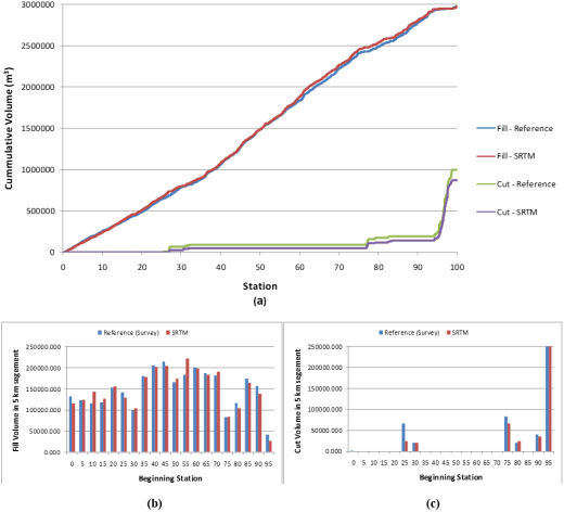
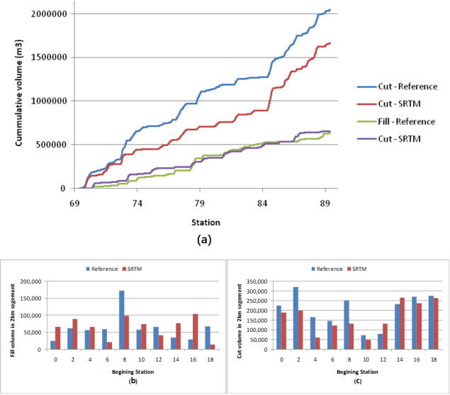
Finally, relative accuracy of SRTM and Reference TIN surfaces was made by separately designing a road vertical curve on TIN surface created on SRTM and reference ground elevation along the road corridor. The road vertical alignment design on each surfaces was made by keeping the relative road profiles grade clearance the same. Besides, the locations of the point of vertical interception (PVI) and length of vertical curves were unchanged. Although, there are some discrepancies in relative difference between the two surfaces, road profiles in flat terrains is often determined by drainage consideration and an equal vertical clearance were provides for both surfaces of study site 1. Thus method used is sufficiently reliable and accurate. Earthwork quantities were calculated using the TIN surface extracted from SRTM DEM and the actual ground surveying. These were quantified for each 20 m section of roadway.
Figures 6(a) & 7(a) shows the cumulative cut and fill volume over a 100 km section of study site 1 and 20 km section of study site 2.
Figure 6(b) and (c) are fill and cut volumes, respectively for each 5 km interval in section from Station 0+000 to 100+000 on Ali Ethiopia - degehamedo road and
Figure 7(b) and 7(c) are fill and cut volume, respectively for each 2 km interval on Ababla - Irepti road corridor (study site 2).
Over the 100 km stretch of the road 1 (Ali Ethiopia - Deghamedo), the cumulative quantity of fill determined from SRTM extracted TIN surface was 2,974,376.44 cubic meter versus a cumulative quantity of 2,978,941.03 cubic meter calculated from reference surface. The cumulative quantity of cut over this interval calculated from SRTM DEM extracted surface was 869, 99.18 cubic meter, versus a cumulative quantity of 1,000,080.77 cubic meter calculated from reference surface. The similarities between the trends in the cumulative data indicate that SRTM DEM extracted surface provides a robust result. The difference in cumulative fill volume is less than 0.2%, whereas the cumulative cut volume from SRTM surface is 13% less than the actual cut volume. Although 13% difference in cumulative cut volume difference seems significant, it’s only underestimated the total road construction cost by 1.1%.
Over the 20 km stretch of the road 2 (Abala - Irepti), the cumulative quantity of fill determined from SRTM extracted TIN surface was 658,381.85 cubic meter versus a cumulative quantity of 634,959.82 cubic meter calculated from reference surface. The cumulative quantity of cut over this interval calculated from SRTM DEM extracted surface was 2,050,424.11 cubic meter, versus a cumulative quantity of 1,663444.77 cubic meter calculated from reference surface. The difference in cumulative fill volume is about 3.68%, whereas the cumulative cut volume from SRTM surface is 18.87% less than the actual cut volume. Although difference in cumulative cut and fill volume difference seems significant, its only underestimated the total road construction cost of Irepti - Abala Road by 8.5%, which is still much less than the 30% tolerance set by ERA 2013 manual for cost estimation during route selection stage.
Figure 6. Ali Ethiopia road earthwork quantities from SRTM and reference data (a) Cumulative earthwork volume. (b) Fill volume in every 5 km segment. (c) Cut volume in every 5 km segment.
Figure 7. Irebti Abala road earthwork quantities from SRTM and reference data (a) Cumulative earthwork volume. (b) Fill volume in every 5 km segment. (c) Cut volume in every 5 km segment.
4. Conclusions and Recommendations
4.1. Conclusions
The accuracies of near-global DEMs-SRTM V.4 and ASTER GDEM2 free available digital elevation models were compared against a reference elevation data collected from field surveying along Ali Ethiopia - Degehamed road corridor and Abala - Irepti road corridor. DEM differencing, correlation plots, and, profiling are some of the methods employed in the comparison. The comparison results in both study sites reveals a RMSE value of ASTER GDEM2 vs. reference data are greater than the RMSE values of SRTM. Results obtained indicate that, the overall accuracy (in terms of RMSE) of both SRTM, and ASTER GDEM is in line with the reported official accuracy specifications
. The linear regression analysis revealed strong correlation between the two DEMs and the reference data. The linear regression data showed this correlation to be highly significant for the study area. In fact the value of the slope of the regression line was very close to 1. The visual analyses of the ASTER GEODEM v.2, SRTM v4.1 plotted profiles taking the ground surveying DEM based profile as reference; the results revealed that ASTER GDEM has an underestimation of elevation (i.e. negatively biased) while SRTM has an overestimation of elevation. The quantity of overestimation of SRTM is less than the quantity of underestimation of ASTER GDEM. In other words, SRTM is “closer” to the reference than ASTER GDEM... According to the results achieved, it is possible to state that SRTM DEM is more accurate than ASTER DEM. The relative vertical accuracy of SRTM DEM derive TIN surface was compared with TIN surface created from ground surveying. The comparison was made by quantifying the cut and fill volumes b/n the ground TIN surfaces and the finished road surfaces, the result revealed that for the study site 1, the difference in cumulative fill volume is less than 1%, whereas the cumulative cut volume from SRTM surface is 13% below the actual cut volume. Similarly, for the study site 2, the difference in cumulative fill volume is about 3.68%, whereas the cumulative cut volume from SRTM surface is 18.87% less than the actual cut volume. The total road construction cost based on SRTM data and actual design were compared and it was found that SRTM has under estimated the overall road construction cost by 1.1% for the study site in flat terrain, and 8.5% for the road in the mountainous terrain. For both cases, the estimated road construction cost falls within ERA 30% requirement. Overall, although ERA recommends the use of SRTM image for flat topography, based on this study SRTM can reasonably predict early road construction costs for all types of terrain conditions. In addition, despite ASTER being favored by road design consultants working with ERA, the results obtained in this study indicate that SRTM accuracy is better than ASTER.
4.2. Recommendations
The following suggestions are put forth in light of the study's results and conclusions:
SRTM Adoption for Initial Road Design: For topographical mapping and earthwork estimation at the route selection stage of road projects, SRTM v4.1 should be chosen due to its superior vertical accuracy over ASTER GDEM2, as evidenced by lower RMSE values and better correlation with ground survey data, particularly in flat and moderately rugged terrain.
Using a ground survey in the last stages of design: It is advised that thorough ground surveying continue to be the norm for final alignment and construction design, even though SRTM has an adequate level of accuracy for early-stage design. This is especially true in hilly areas where differences in cut volumes could have a substantial financial impact.
Review of the ERA Guidelines: For rough terrain, ASTER GDEM2 is now advised by the Ethiopian Roads Authority (ERA). But according to this study, SRTM v4.1 works better in both flat and hilly environments. Based on recent empirical accuracy evaluations like this one, ERA ought to think about updating its route selection policies.
Design Workflow Integration with DEM Accuracy Assessment: To guarantee the accuracy of volume calculations and reduce the dangers of under- or over-estimation, road design consultants and engineers should regularly validate the DEM accuracy against control points before using them for cost estimation or design.
Abbreviations
ASTER | Advanced Spaceborne Thermal Emission and Reflection Radiometer |
DEM | Digital Elevation Model |
ERA | Ethiopian Roads Authority |
GDEM | Global Digital Elevation Model |
GIS | Geographic Information System |
GPS | Global Positioning System |
JPL | Jet Propulsion Laboratory |
METI | Ministry of Economy, Trade and Industry (Japan) |
NASA | National Aeronautics and Space Administration |
Acknowledgments
The author wishes to express sincere gratitude to Mattu University for its support throughout the course of this research. The academic and institutional assistance provided was instrumental in the successful completion of this work.
Special thanks go to my advisors, Dr. Tarekegn Kumala and Eng. Fikedu Rage, for their invaluable guidance, encouragement, and expertise. Their thoughtful supervision and continuous support greatly contributed to the quality and completion of this thesis.
The author is also grateful to all colleagues, friends, and family members whose encouragement and support helped make this journey possible.
Author Contributions
Gadisa Shiferaw is the sole author. The author read and approved the final manuscript.
Conflicts of Interest
The author declares no conflicts of interest.
References
| [1] |
K. S. J. &. A. A. Aruga, "Application of an airborne laser scanner to forest road design with accurate earthwork volumes", Journal of Forest Research, pp. 10, 113-123, 2005.
|
| [2] |
T. a. S. J. Blaschke, "Defining Landscape Units through Integrated Morphometric Characteristics. In: Buhmann, E. and Ervin, S., Eds., Landscape In: Buhmann, E. and Ervin, S., Eds., Landscape", Digital Techniques for Landscape Architecture, Wichmann-Verlag, Heidelberg, pp. 104-113, 2003.
|
| [3] |
M. A. P. &. C. W. Contreras, "Improving Accuracy in Earthwork Volume Estimation for Proposed Forest Roads Using a High-Resolution Digital Elevation Model", Croatian Journal of Forest Engineering: Journal for Theory and Application of Forestry Engineering, pp. 33, 125-142, 2012.
|
| [4] |
P. &. T. N. Fisher, "Causes and consequences of error in digital elevation models", Progress in Physical Geography, pp. 30, 467-489, 2006.
|
| [5] |
J. B. A. M. M. &. B. X. Goetz, "Modeling the precision of structure-from-motion multi-view stereo digital elevation models from repeated close-range aerial surveys", Remote Sensing of Environment, 2018.
|
| [6] |
P. N. A. G. C. M. J. H. L. F. I. G. D. R. H. H.-C. V. R. S. L.-V. C. C. C. A. C. &. S. P. Guth, "Guth, P., Niekerk, A., Grohmann, C., Muller, J., Hawker, L., Florinsky, I., Gesch, D., Reuter, H., Herrera-Cruz, V., Riazanoff, S., López-Vázquez, C., Carabajal, C., Albinet, C., & Strobl, P.", Remote. Sens, 13, 3581, 2021.
|
| [7] |
W. Ha, "Applications of 3D Visualization in Road Profile Design and Earthwork Calculation", Surveying and Mapping of Geology and Mineral Resources, 2015.
|
| [8] |
J. &. H. M. Höhle, "Accuracy assessment of digital elevation models by means of robust statistical methods", Isprs Journal of Photogrammetry and Remote Sensing, pp. 64, 398-406, 2009.
|
| [9] |
M. &. Z. N. Zhao, "Method for the Construction of Urban Road Digital Elevation Models Integrated with Semantic Information", Applied Sciences, 2023.
|
| [10] |
L. Yu, "Earthwork Optimal Allocation Model of Road Engineering Based on BIM Technology", Proceedings of the 2022 2nd International Conference on Control and Intelligent Robotics, 2022.
|
| [11] |
S. C. Y. Y. F. &. M. M. Yao, "A continuous digital elevation representation model for DEM super-resolution", ISPRS Journal of Photogrammetry and Remote Sensing, 2024.
|
| [12] |
E. A. S. M. B. M. M. &. K. A. Uuemaa, "Vertical Accuracy of Freely Available Global Digital Elevation Models (ASTER, AW3D30, MERIT, TanDEM-X, SRTM, and NASADEM)", Remote. Sens, 12, 3482, 2020.
|
| [13] |
S. G. R. a. G. A. Snehmani, " Extraction of High Resolution", Journal of Remote Sensing and GIS (JORSG), pp. 4, 23-34, 2013.
|
| [14] |
S. J. P. M. S. G. A. G. R. &. M. A. Mukherjee, "Evaluation of vertical accuracy of open source Digital Elevation Model (DEM)", Int. J. Appl. Earth Obs. Geoinformation, pp. 21, 205-217, 2013.
|
| [15] |
H. L. H. R. M. &. G. R. Liu, "Development of road grade data using the United States geological survey digital elevation model", Transportation Research Part C: Emerging Technologies, 2018.
|
Cite This Article
-
APA Style
Shiferaw, G. (2025). Comparison of Srtm and Aster Derived Elevation Models Along Ali Ethiopia - Deghamedo and Abala - Irepti Road Corridors. American Journal of Traffic and Transportation Engineering, 10(3), 69-79. https://doi.org/10.11648/j.ajtte.20251003.12
 Copy
|
Copy
|
 Download
ACS Style
Shiferaw, G. Comparison of Srtm and Aster Derived Elevation Models Along Ali Ethiopia - Deghamedo and Abala - Irepti Road Corridors. Am. J. Traffic Transp. Eng. 2025, 10(3), 69-79. doi: 10.11648/j.ajtte.20251003.12
Copy
|
Download
AMA Style
Shiferaw G. Comparison of Srtm and Aster Derived Elevation Models Along Ali Ethiopia - Deghamedo and Abala - Irepti Road Corridors. Am J Traffic Transp Eng. 2025;10(3):69-79. doi: 10.11648/j.ajtte.20251003.12
Copy
|
Download
-
@article{10.11648/j.ajtte.20251003.12,
  author = {Gadisa Shiferaw},
  title = {Comparison of Srtm and Aster Derived Elevation Models Along Ali Ethiopia - Deghamedo and Abala - Irepti Road Corridors
},
  journal = {American Journal of Traffic and Transportation Engineering},
  volume = {10},
  number = {3},
  pages = {69-79},
  doi = {10.11648/j.ajtte.20251003.12},
  url = {https://doi.org/10.11648/j.ajtte.20251003.12},
  eprint = {https://article.sciencepublishinggroup.com/pdf/10.11648.j.ajtte.20251003.12},
  abstract = {The earthwork estimation has a huge impact on the construction cost of the road. Therefore, the initial road design relies on precise terrain modeling. In this context, a low cost data offered by Digital Elevation Models (DEMs) are introduced. This study assessed the performances of three freely available DEMs; ALOS, SRTM and ASTER in flat, rolling and mountainous terrain for road design. Digital Elevation Models (DEMs) are helpful for estimating cut-and-fill volumes in a road construction project. Not being accurate can cost too much. This study aims to examine the accuracy of DEMs by comparing them with field survey data and their suitability for earthwork estimation in various terrain conditions. The study used statistical methods for error Analysis like Root mean square error calculations. Elevation profile and percentage error for comparison between DEM data versus reference ground survey data. The cut-and-fill volumes were estimated using TIN surfaces created from each DEM and the actual surveyed estimates were compared. The study found that the most accurate DEM was from ALOS with RMSE value for flat terrain, rolling terrain and mountainous terrain being 4.89 m, 5.14 m and 27.96 m respectively. The heights recorded by SRTM were relatively better with RMSE of 5.02 m, 5.47 m and 29.75 m whereas those from ASTER were the worst with RMSE of 9.15 m, 8.51 m and 30.51 m. The percentage errors in earthwork estimations for cut volumes recorded using ALOS were the lowest 21.28% (flat), 15.64% (rolling) and 47.93% (mountainous) while those of ASTER were 42.45%, 47.33% and 55.20% respectively and STRM were 31.28%, 36.26% and 47.43%. The study found that ALOS produces the best elevation and earthwork estimates, compared to SRTM and ASTER. ALOS is a very accurate sensor with very high accuracy on flat and rolling terrains and reduced accuracy on all models in mountainous terrain. ALOS is so effective that using them could help improve the cost estimation significantly and lessen the uncertainty of money in the road construction. In the future, scientists should work on dealing ALOS data with other sets of geospatial data. Also, a cost-benefit analysis of ALOS-based models in large-scale infrastructure projects can help us understand its application better.},
 year = {2025}
}
Copy
|
Download
-
TY  - JOUR
T1  - Comparison of Srtm and Aster Derived Elevation Models Along Ali Ethiopia - Deghamedo and Abala - Irepti Road Corridors

AU  - Gadisa Shiferaw
Y1  - 2025/07/22
PY  - 2025
N1  - https://doi.org/10.11648/j.ajtte.20251003.12
DO  - 10.11648/j.ajtte.20251003.12
T2  - American Journal of Traffic and Transportation Engineering
JF  - American Journal of Traffic and Transportation Engineering
JO  - American Journal of Traffic and Transportation Engineering
SP  - 69
EP  - 79
PB  - Science Publishing Group
SN  - 2578-8604
UR  - https://doi.org/10.11648/j.ajtte.20251003.12
AB  - The earthwork estimation has a huge impact on the construction cost of the road. Therefore, the initial road design relies on precise terrain modeling. In this context, a low cost data offered by Digital Elevation Models (DEMs) are introduced. This study assessed the performances of three freely available DEMs; ALOS, SRTM and ASTER in flat, rolling and mountainous terrain for road design. Digital Elevation Models (DEMs) are helpful for estimating cut-and-fill volumes in a road construction project. Not being accurate can cost too much. This study aims to examine the accuracy of DEMs by comparing them with field survey data and their suitability for earthwork estimation in various terrain conditions. The study used statistical methods for error Analysis like Root mean square error calculations. Elevation profile and percentage error for comparison between DEM data versus reference ground survey data. The cut-and-fill volumes were estimated using TIN surfaces created from each DEM and the actual surveyed estimates were compared. The study found that the most accurate DEM was from ALOS with RMSE value for flat terrain, rolling terrain and mountainous terrain being 4.89 m, 5.14 m and 27.96 m respectively. The heights recorded by SRTM were relatively better with RMSE of 5.02 m, 5.47 m and 29.75 m whereas those from ASTER were the worst with RMSE of 9.15 m, 8.51 m and 30.51 m. The percentage errors in earthwork estimations for cut volumes recorded using ALOS were the lowest 21.28% (flat), 15.64% (rolling) and 47.93% (mountainous) while those of ASTER were 42.45%, 47.33% and 55.20% respectively and STRM were 31.28%, 36.26% and 47.43%. The study found that ALOS produces the best elevation and earthwork estimates, compared to SRTM and ASTER. ALOS is a very accurate sensor with very high accuracy on flat and rolling terrains and reduced accuracy on all models in mountainous terrain. ALOS is so effective that using them could help improve the cost estimation significantly and lessen the uncertainty of money in the road construction. In the future, scientists should work on dealing ALOS data with other sets of geospatial data. Also, a cost-benefit analysis of ALOS-based models in large-scale infrastructure projects can help us understand its application better.
VL  - 10
IS  - 3
ER  -
Copy
|
Download