1. Introduction
Petroleum accumulations are commonly believed to have formed over millions of years. However, a literal reading of scripture indicates a young Earth
. A number of Creationist papers on petroleum have emphasized its origin (e.g.)
| [38] | McQueen, D. R. 1986. The Chemistry of Oil - Explained by Flood Geology. Acts & Facts. 15 (5). |
[38]
and its rapid formation (eg
| [7] | Bruce, R. H. 2021. Millions of years are not necessary for petroleum formation. Journal of the Bible Creation Trust, 3, 7-11. |
| [18] | Dickens, H. 2023a. Petroleum systems do not require millions of years. Journal of Creation, 37(3): 12-15. |
| [54] | Snelling, A. A. 1990. How fast can oil form? Creation Ex Nihilo, 12(2): 30-34. |
[7, 18, 54]
). A biblical young Earth history stage model has been proposed with an emphasis on the drying stage and on evidence from coal types. It was concluded that the end of the Flood Years’ time of drying may be correlated with the lithological and floral evidence for widespread drying of the Triassic period
| [17] | Dickens, H. 2022. A Proposed Model For The Drying And Related Stages of Noah’s Flood. Origin Research Journal, 2(1), 38-64. |
[17]
.
A paper reviewed the regional occurrence and geology of petroleum reserves
| [19] | Dickens, H. 2023b. A review of the occurrence and geology of petroleum reserves: a primer for creationists. Origin Research Journal, 3(2): 28-51. |
[19]
. Relevant background was presented on tectonic settings of basins (including post-Paleozoic changes), sedimentary deposition, and the nature of different source rocks. Overall trends in petroleum reserves through time were discussed. Petroleum geology was then discussed for the specific Neoproterozoic, Cambrian to Mississippian, Pennsylvanian-Permian, Triassic, Jurassic-Cretaceous and Tertiary intervals. Non-marine as well as marine organic matter and sediments were considered.
This paper builds on the previously proposed model for stages of Noah’s Flood and its aftermath, including the widespread drying stage
| [17] | Dickens, H. 2022. A Proposed Model For The Drying And Related Stages of Noah’s Flood. Origin Research Journal, 2(1), 38-64. |
[17]
. This paper provides a biblical framework for regional occurrence and geology of petroleum reserves
| [19] | Dickens, H. 2023b. A review of the occurrence and geology of petroleum reserves: a primer for creationists. Origin Research Journal, 3(2): 28-51. |
[19]
.
The missing factor in most Flood models to date is scriptural - the months of drying recorded in Genesis 8. Currently, a widely known Flood tectonic model that lacks the drying factor is catastrophic plate tectonics (CPT)
, 3,
9]. This was a pioneering attempt to try to tie aspects of geology together in a conceptual or theoretical physical way. The model uses computer modelling and aspects of the modern theory of plate tectonics. Theoretical mathematical models need to be correlatable to the observable successive stratigraphic record in order to be realistic. The CPT model could perhaps be enhanced if formations representing the Flood Year’s receding waters and drying phases were considered in a specific time sequence. The length of these phases is of the order of 7 months (Genesis 8: 1-19)
| [20] | Dickens, H. 2023c. Receding Noahic Flood Waters Led to Seafloor Spreading: A Proposed Geological Model. In J. H. Whitmore (editor), Proceedings of the Ninth International Conference on Creationism, 446-477. Cedarville, Ohio: Cedarville University International Conference on Creationism. https://doi.org/10.13140/RG.2.2.23615.48809 |
[20]
. The two common endFlood views (KPg and Cenozoic) also lack the scriptural factor of the months of drying.
The Scripture's drying stage and its correlation with stratigraphy are found in
A Proposed Model For The Drying And Related Stages of Noah’s Flood | [17] | Dickens, H. 2022. A Proposed Model For The Drying And Related Stages of Noah’s Flood. Origin Research Journal, 2(1), 38-64. |
[17]
and in ICC2023’s
Receding Noahic Flood Waters Led to Seafloor Spreading: A Proposed Geological Model (RTS)
| [20] | Dickens, H. 2023c. Receding Noahic Flood Waters Led to Seafloor Spreading: A Proposed Geological Model. In J. H. Whitmore (editor), Proceedings of the Ninth International Conference on Creationism, 446-477. Cedarville, Ohio: Cedarville University International Conference on Creationism. https://doi.org/10.13140/RG.2.2.23615.48809 |
[20]
. The latter paper was subsequently made into a book at the request of Lambert Academic Publishing.
The RTS model covers events from the Scripture record in a stage-by-stage manner and correlates this with specific successive mappable stratigraphy. Stages discussed in the RTS paper include destruction of pre-Flood topography, global marine transgression, receding and drying phases, seafloor spreading and continental mountain building, and then the ice age.
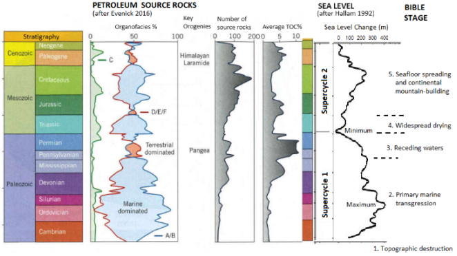
The organofacies are kerogen types. A/B is marine dominated, C is lacustrine-related, D/E/F are predominantly coals and terrestrial-related shales. TOC is total organic carbon.
Two first order global sea level cycles or supercycles can be seen in the sea level curve. They are associated with supercontinent fragmentation. I infer
| [20] | Dickens, H. 2023c. Receding Noahic Flood Waters Led to Seafloor Spreading: A Proposed Geological Model. In J. H. Whitmore (editor), Proceedings of the Ninth International Conference on Creationism, 446-477. Cedarville, Ohio: Cedarville University International Conference on Creationism. https://doi.org/10.13140/RG.2.2.23615.48809 |
[20]
that:
Supercycle One correlates with Noahic Flood waters rising and falling. In this curve, the Ordovician is the highest sea level and I correlate this with globe-covering water at the peak of Noah’s Flood.
Supercycle Two correlates with the subsequent time of seafloor spreading and opening up of the oceans now seen between today’s continents. I infer that the Cretaceous high, relates to hot expanded mid-ocean ridges displacing water onto continents to form interior seaways, but not completely covering the continents.
2. A Proposed Biblical Young Earth Model
2.1. Stages and Tectonism
From the book of Genesis, successive historical stages can be recognized, especially in the Flood Year record. The challenge is how to correlate successive historical stages inferred from the geological record with the Bible’s stages. The Flood Year account has specific stages including fountains bursting forth, 40 days and nights of rain and topographic destruction, marine transgression, marine regression and drying. A portion of, but not the entire, Flood Year had a global ocean
| [17] | Dickens, H. 2022. A Proposed Model For The Drying And Related Stages of Noah’s Flood. Origin Research Journal, 2(1), 38-64. |
| [20] | Dickens, H. 2023c. Receding Noahic Flood Waters Led to Seafloor Spreading: A Proposed Geological Model. In J. H. Whitmore (editor), Proceedings of the Ninth International Conference on Creationism, 446-477. Cedarville, Ohio: Cedarville University International Conference on Creationism. https://doi.org/10.13140/RG.2.2.23615.48809 |
[17, 20]
.
Tectonic upheavals (including areas of uplift and of subsidence) may have taken place throughout the Flood Year with global sedimentary and volcanic processes taking place. Regional tectonism has a significant role in the types of organofacies or kerogen types and their sedimentary settings
| [24] | Evenick, J. C. 2016. Research highlights spatial, temporal variability in source rocks through the Phanerozoic. Oil & Gas Journal, December 5, 2016, 50-54. |
[24]
(
figure 2), and thus it is helpful for orogenies to be considered in our biblical geological history models.
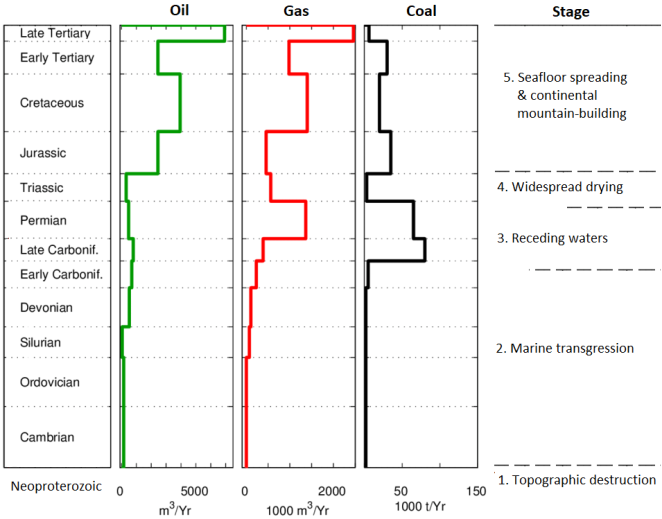
2.2. Stage 1: Topographic Destruction (Neoproterozoic; Figures 1 and 2) The early Flood Year was a time of destruction of the earth (Genesis 6: 13 and 2 Peter 3: 6), with great fountain flows and extensive colossal rain (Genesis 7: 11-12). In the Mabbul, or early Flood year, all people and land animals outside the ark were wiped away during the 40 days and nights of rain
| [5] | Boyd, S. W. 2016. The Last Week before the Flood: Noah on Vacation or Working Harder than Ever? Answers Research Journal, 9, 197–208. |
[5]
. Land vertebrates (animals and people) were blotted out and destroyed with the earth (Genesis 6: 7, 13; 7: 4), at this time of enormous rain. Consistent with the time of enormous rain, the Great Unconformity on many continents
| [10] | Clarey, T. 2021. Great Unconformity Best Solved by Global Flood. Acts and Facts September 20. |
| [15] | Dickens, H. 2016. The ‘Great Unconformity’ and Associated Geochemical Evidence for Noahic Flood Erosion. Journal of Creation, 30(1), 8–10. |
| [16] | Dickens, H. 2018. North American Precambrian geology–A proposed young earth biblical model. In Proceedings of the Eighth International Conference on Creationism, ed. J. H. Whitmore, 389–403. Pittsburgh, Pennsylvania: Creation Science Fellowship. |
[10, 15, 16]
is evidence of early Flood immense continental erosion and the destruction of topography. The Great Unconformity at the Grand Canyon demonstrates that even hard crystalline granite and schist was eroded down many kilometers
| [37] | McDannell, K. T., Keller, C. B., Guenthner, W. R., Zeitler, P. K. and Shuster, D. L. 2022. Thermochronologic constraints on the origin of the Great Unconformity. Proceedings of the National Academy of Sciences. 119(5): e2118682119. https://doi.org/10.1073/pnas.2118682119 |
[37]
and peneplaned. This indicates catastrophic erosive destruction of pre-Flood land biomes with their terrestrial vertebrates. The long-held model of gradual destruction of ecological zones by the rising waters of Noah’s Flood, known as the ecological zonation model
| [11] | Clark, H. W. 1946. The New Diluvialism. Science Publications, Angwin, California. |
[11]
is not consistent with extremely deep and powerful catastrophic erosion.
There would be no escape going uphill against huge mass flows and stupendous erosive currents flowing downhill. Instead, pre-Flood land animals and people were blotted out due to the extremely powerful erosion. The Hebrew word machah in Genesis 7: 4 is translated as “blotted out” in common Bible versions. The word also implies erasing according to Strong’s Concordance
| [57] | Strong, J. 2010. The new Strong's expanded exhaustive concordance of the Bible. Thomas Nelson. |
[57]
. The key destructive process involved is inferred to be the extreme and fine abrasion of land vertebrates early in the Flood Year such that their bones were not preserved
| [21] | Dickens, H. and Hutchison, A. 2021a. The Flood Swept Away Pre-Flood Lives! Journal of Creation Theology and Science Series C: Earth Sciences 11, 1-4 (Creation Geology Society Annual Conference Abstracts. https://doi.org/10.13140/RG.2.2.24199.52644 |
[21]
. Nutrients from abraded bones would then have contributed to massive Precambrian-Cambrian transition phosphorite deposits
| [23] | Dickens, H. and Snelling, A. A. 2015. Terrestrial Vertebrates Dissolved Near Flood Fountains. Answers Research Journal, 8, 437–447. |
[23]
and have fed algal blooms (which provide a source for oil). Algae and finely abraded plant material would have contributed fine organic matter to black shale petroleum source rocks.
The term Mabbul is only mentioned in Genesis and in Psalm 29. Violent processes described include breaking of trees, forests stripped bare, earth shaking and fire (Psalm 29: 5-9). I associate the early massive coal measures with the Mabbul. In other words, land vegetation was stripped off the Pre-Flood supercontinent by the action of enormous erosive currents generated by massive and geographically extensive rain, earth shaking and volcanic-related fountains activity. Pre-Flood forests were ripped off the land by intensive erosion and being buoyant, they floated
| [17] | Dickens, H. 2022. A Proposed Model For The Drying And Related Stages of Noah’s Flood. Origin Research Journal, 2(1), 38-64. |
| [20] | Dickens, H. 2023c. Receding Noahic Flood Waters Led to Seafloor Spreading: A Proposed Geological Model. In J. H. Whitmore (editor), Proceedings of the Ninth International Conference on Creationism, 446-477. Cedarville, Ohio: Cedarville University International Conference on Creationism. https://doi.org/10.13140/RG.2.2.23615.48809 |
[17, 20]
. In the receding waters stage, this bulk of vegetation came to ground and was buried to later become Late Paleozoic coal measures
(figures 1 and 2).
The Flood fountains (Genesis 7: 11-12) provided warm waters that would have encouraged algae growth, a great oil source. Tectonism and earth movement associated with Flood fountains bursting open and related water flows would have produced episodes that buried algae. This would have led to the formation of oil reserves such as in the Neoproterozoic of the Siberian Platform, India, Oman and China. Sea level began to rise in the seas adjacent to the land, culminating in the Cambrian marine transgression over the land
| [14] | Dalziel, I. W. D. 2014. Cambrian transgression and radiation linked to an Iapetus-Pacific oceanic connection? Geology, 42(11), 979-982. https://doi.org/10.1130/G35886.1 |
[14]
.
2.3. Stage 2: Marine Transgression Stage (Cambrian to Mississippian; Genesis 7: 17-20, 24; Figures 1 and 2) The world became completely covered by the water of Noah’s Flood. Consistent with this, the earlier Paleozoic was a time of high sea level
(figure 2) and eustatic global sea level reached its Phanerozoic maximum in the Ordovician
| [6] | Bradley, D. C. 2011. Secular trends in the geologic record and the supercontinent cycle. Earth-Science Reviews, 108, 16-33. https://doi.org/10.1016/j.earscirev.2011.05.003 |
| [27] | Hallam, A. 1984. Pre-Quaternary Sea-level Changes. Annual Review of Earth and Planetary Sciences, 12, 205-243. |
| [47] | Peters, S. E. 2008. Macrostratigraphy and Its Promise for Paleobiology. In From Evolution to Geobiology: Research Questions Driving Paleontology at the Start of a New Century, Paleontological Society Short Course, October 4, 2008. Paleontological Society Papers, Volume 14, Patricia H. Kelley and Richard K. Bambach. (Eds.). |
[6, 27, 47]
. There is a general trend of marine dominated organofacies A/B when sea level was high, especially in the Cambrian to end Mississippian
| [24] | Evenick, J. C. 2016. Research highlights spatial, temporal variability in source rocks through the Phanerozoic. Oil & Gas Journal, December 5, 2016, 50-54. |
| [27] | Hallam, A. 1984. Pre-Quaternary Sea-level Changes. Annual Review of Earth and Planetary Sciences, 12, 205-243. |
| [46] | Peters, S. E. 2006. Macrostratigraphy of North America. The Journal of Geology, 114, 391-412. https://doi.org/10.1086/504176 |
[24, 27, 46]
. Carbon dioxide from Flood fountains may have contributed to the formation of large marine carbonate deposits such as the Great American Carbonate Bank of the Sauk Megasequence in North America, western South America, Scotland and Greenland
| [22] | Dickens, H. and Hutchison, A. 2021b. Geochemical and related evidence for early Noah’s Flood year. Journal of Creation, 35(1), 78-88. |
[22]
. Lower Paleozoic source rocks with exclusively marine organic matter are in contrast to Tertiary source rocks with dominantly terrestrial organic matter
| [32] | Klemme, H. D. and Ulmishek, G. F. 1999. Effective Petroleum Source Rocks of the World: Stratigraphic Distribution and Controlling Depositional Factors. AAPG Bulletin, 75, 1809-1851. |
[32]
(
figure 2). In North America, Cambrian to Mississippian sedimentary successions are dominated by marine carbonates, whereas post-Paleozoic successions are dominated by terrigenous clastics
.
Paleozoic epicontinental seas were shallow and their gently sloping seabed was consistent with the erosive peneplanation of the underlying basement in the topographic destruction stage of the Flood
| [17] | Dickens, H. 2022. A Proposed Model For The Drying And Related Stages of Noah’s Flood. Origin Research Journal, 2(1), 38-64. |
[17]
. Sedimentation then took place on shallow marine platforms. Most Paleozoic oil source rocks and reservoir beds were deposited in stable platform or cratonic sedimentary environments, formed by shallow seas adjacent to Precambrian cratons. The geologic setting indicated by Paleozoic strata was quite different from the settings of the Mesozoic and Cenozoic.
| [4] | Bois, C., Bouche, P. and Pelet, R. 1982. Global geologic history and distribution of hydrocarbon reserves. AAPG Bulletin, 66(9), 1248-1270. |
| [60] | Tissot, B. P. and Welte, D. H. 1984. Petroleum Formation and Occurrence. Second edition. Springer-Verlag. |
[4, 60]
.
The predominant North American carbonates are believed to have been deposited in warm waters, with dolomites and evidence of carbonate development beginning in the Ordovician times.
| [4] | Bois, C., Bouche, P. and Pelet, R. 1982. Global geologic history and distribution of hydrocarbon reserves. AAPG Bulletin, 66(9), 1248-1270. |
[4]
. During Middle Devonian to Mississippian times, these carbonates reached their maximum extent around the craton and reef structures were impressively developed in Canada
| [4] | Bois, C., Bouche, P. and Pelet, R. 1982. Global geologic history and distribution of hydrocarbon reserves. AAPG Bulletin, 66(9), 1248-1270. |
[4]
.
For 150 days (Genesis 8: 2-3) Flood fountains continued to provide warm waters that would have encouraged algae growth, a great oil source. Ongoing tectonism and earth movement associated with active Flood fountains and related water flows would have produced further episodes that buried algae. This would have encouraged the formation of more oil. Microscopic marine algae (phytoplankton) dominated the biosphere, contributing to the rich organic matter of dark and black marine shales, which are the normal open marine sediments of the Lower Paleozoic
| [60] | Tissot, B. P. and Welte, D. H. 1984. Petroleum Formation and Occurrence. Second edition. Springer-Verlag. |
[60]
. Silurian and Devonian shale source rocks deposited on shallow marine platforms contain mainly oil-prone kerogen types I and II
| [56] | Sorkhabi, R. 2016. Rich Petroleum Source Rocks. GEO ExPro, 6(6), 1-12. |
[56]
. The major Silurian source rocks are known in North Africa, Southwest Asia (Middle East), and the USA (the Anadarko, Permian, and Michigan basins). Devonian source rocks are known in North America (Alberta, Williston, Permian, Anadarko, Michigan, Illinois, and Appalachian basins), South America (Amazon and Bolivia), North Africa (Algeria), Eastern Europe, and the Ural basins
| [56] | Sorkhabi, R. 2016. Rich Petroleum Source Rocks. GEO ExPro, 6(6), 1-12. |
[56]
.
The average total organic carbon% is smaller in Lower Paleozoic rocks (
figure 2) and there are no significant coal measures before the Late Paleozoic (
figure 1). This has been associated with the lack of land-based plants
| [24] | Evenick, J. C. 2016. Research highlights spatial, temporal variability in source rocks through the Phanerozoic. Oil & Gas Journal, December 5, 2016, 50-54. |
[24]
. I infer that this is because relatively buoyant logs stripped of the land in the early Flood were floating
| [17] | Dickens, H. 2022. A Proposed Model For The Drying And Related Stages of Noah’s Flood. Origin Research Journal, 2(1), 38-64. |
| [20] | Dickens, H. 2023c. Receding Noahic Flood Waters Led to Seafloor Spreading: A Proposed Geological Model. In J. H. Whitmore (editor), Proceedings of the Ninth International Conference on Creationism, 446-477. Cedarville, Ohio: Cedarville University International Conference on Creationism. https://doi.org/10.13140/RG.2.2.23615.48809 |
[17, 20]
.
2.4. Stage 3: Receding Waters (Pennsylvanian-Permian); Genesis 8: 1-11; Figures 1 and 2) The world would still have had little topographic relief due to the earlier Flood Year’s enormous continental erosion, and so shallow epicontinental seas would have been common. The time for the receding and drying stage of the Flood (about 7 months) exceeded the time for the marine transgression stage (about 5 months) of the whole Flood Year as recorded in Genesis 8.
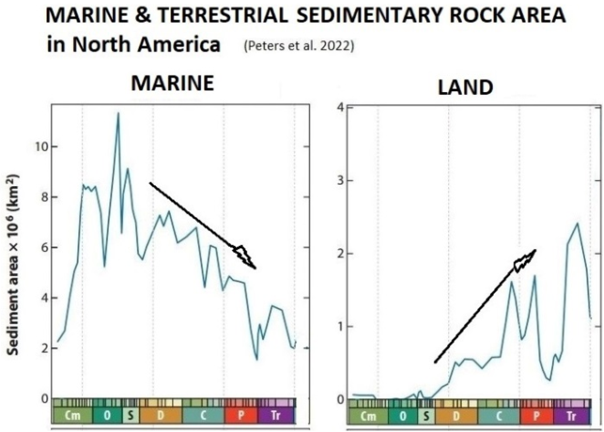
During the 7 months of receding and drying, land would have begun to appear and progressively increase in areal extent (
figure 3). At least since these phases of the Flood Year, there would be both marine and non-marine settings, rather than a globe-covering ocean. Non-marine depositional settings such as lakes and rivers would then have begun to appear and increase on the supercontinent
| [17] | Dickens, H. 2022. A Proposed Model For The Drying And Related Stages of Noah’s Flood. Origin Research Journal, 2(1), 38-64. |
| [20] | Dickens, H. 2023c. Receding Noahic Flood Waters Led to Seafloor Spreading: A Proposed Geological Model. In J. H. Whitmore (editor), Proceedings of the Ninth International Conference on Creationism, 446-477. Cedarville, Ohio: Cedarville University International Conference on Creationism. https://doi.org/10.13140/RG.2.2.23615.48809 |
[17, 20]
. Lakes became much more evident from strata of mid-Permian onwards
| [24] | Evenick, J. C. 2016. Research highlights spatial, temporal variability in source rocks through the Phanerozoic. Oil & Gas Journal, December 5, 2016, 50-54. |
[24]
. At the end of the Paleozoic, the size of the landmass above sea level was 110–120% compared with the present-day landmass due to the worldwide regression
.
In the Pennsylvanian-Permian (particularly during the latter), there was severe marine regression
| [27] | Hallam, A. 1984. Pre-Quaternary Sea-level Changes. Annual Review of Earth and Planetary Sciences, 12, 205-243. |
| [56] | Sorkhabi, R. 2016. Rich Petroleum Source Rocks. GEO ExPro, 6(6), 1-12. |
[27, 56]
(
figure 2). Stratigraphic evidence from Mid-Carboniferous shelf and basin successions in numerous parts of the world indicates a major marine regression
| [19] | Dickens, H. 2023b. A review of the occurrence and geology of petroleum reserves: a primer for creationists. Origin Research Journal, 3(2): 28-51. |
| [34] | Lucien, N. L. 2014. Origin and distribution of the Mississippian-Pennsylvanian boundary unconformity in marine carbonate successions with a case study of the karst development atop the Madison Formation in the Bighorn Basin, Wyoming. Dissertations & Theses in Earth and Atmospheric Sciences. 59. |
| [51] | Ross, C. A. and Ross, J. R. P. 1988. Late Paleozoic transgressive-regressive deposition. In C. K. Wilgus et al., eds. Sea-Level Change: An Integrated Approach. Society of Economic Paleontologists and Mineralogists Special Publication 42, 227–247. |
[19, 34, 51]
. Regressions are inferred from karstification, erosional sedimentary hiatuses and other signs of dessication.
With the primary regression of the Flood Year, floating land plants flowed with water and sediment into lower lying areas such as foreland basins or downwarped cratonic basins
. With tectonism and subsidence plant material was rapidly buried by sediment and later became Carboniferous and Permian coal measures
| [17] | Dickens, H. 2022. A Proposed Model For The Drying And Related Stages of Noah’s Flood. Origin Research Journal, 2(1), 38-64. |
[17]
. Cooling after Flood fountains closed (Genesis 8: 2) may have contributed to graben formation and subsidence. Terrestrial organofacies D/E/F (predominantly coals and terrestrial-related shales) dominated in the Pennsylvanian through Early Permian, during Pangean tectonism (
| [24] | Evenick, J. C. 2016. Research highlights spatial, temporal variability in source rocks through the Phanerozoic. Oil & Gas Journal, December 5, 2016, 50-54. |
[24]
;
figure 2).
From the commonly well-layered nature of coal seams, enormous and widespread sheet flows of water and sediment are likely to have taken place as Flood waters were streaming off the continent. The lack of seatearths and fossil roots
| [33] | Lord, J. H. 1952. Collie Mineral Field. Bulletin of the Geological Survey of Western Australia 105, pt. 1. |
[33]
also provide evidence that coal seams were transported into place, rather than formed in an in situ disordered situation such as a swamp.
Average total organic carbon% was higher in strata from Upper Devonian onwards and reached a maximum in the Pennsylvanian-Permian (
| [24] | Evenick, J. C. 2016. Research highlights spatial, temporal variability in source rocks through the Phanerozoic. Oil & Gas Journal, December 5, 2016, 50-54. |
[24]
;
figure 2). Coal is a good source for natural gas as confirmed by the organic geochemistry of major gas reserves in Late Paleozoic strata.
Post-Palaeozoic coal flora was dominated by plants better suited to drier conditions)
| [17] | Dickens, H. 2022. A Proposed Model For The Drying And Related Stages of Noah’s Flood. Origin Research Journal, 2(1), 38-64. |
| [20] | Dickens, H. 2023c. Receding Noahic Flood Waters Led to Seafloor Spreading: A Proposed Geological Model. In J. H. Whitmore (editor), Proceedings of the Ninth International Conference on Creationism, 446-477. Cedarville, Ohio: Cedarville University International Conference on Creationism. https://doi.org/10.13140/RG.2.2.23615.48809 |
[17, 20]
and this is reflected in the type of hydrocarbons generated from plant sources. For example, Australian Mesozoic and Tertiary coals have generated oil accumulations, whereas Australian Permian coals and Western European Pennsylvanian coals have only generated gas accumulations
| [59] | Thomas, B. M. 1981. Land-plant source rocks for oil and their significance in Australian Basins. APEA Journal, 22, 164-178. https://doi.org/10.1071/AJ81012 |
| [60] | Tissot, B. P. and Welte, D. H. 1984. Petroleum Formation and Occurrence. Second edition. Springer-Verlag. |
[59, 60]
.
The prominent gas reserve peak in the Permian (
figure 1) is believed to be caused by migration from source rocks together with trapping by seals. Gas derived from the thermal cracking of Paleozoic oil has been locally added to gas derived from Permo-Carboniferous coal-rich source rocks. These gases have been trapped by Permo-Triassic evaporites which provide the necessary perfect gas-tight seals for old reservoirs
| [4] | Bois, C., Bouche, P. and Pelet, R. 1982. Global geologic history and distribution of hydrocarbon reserves. AAPG Bulletin, 66(9), 1248-1270. |
[4]
.
2.5. Stage 4: Widespread Drying (Triassic; Genesis 8: 13-14; Figures 1 and 2) Triassic reserves of oil, gas and coal were at a clear minimum
| [60] | Tissot, B. P. and Welte, D. H. 1984. Petroleum Formation and Occurrence. Second edition. Springer-Verlag. |
[60]
. The Triassic minimum of oil sources
| [58] | Strong, J. 2012. Strong’s Hebrew Dictionary of the Bible. www.bnpubling.com . May 21st, 2012. |
[58]
may have resulted from the end Permian eustatic sea level minimum
| [27] | Hallam, A. 1984. Pre-Quaternary Sea-level Changes. Annual Review of Earth and Planetary Sciences, 12, 205-243. |
| [62] | Vail, P. R., Mitchum, R. M., Todd, R. G., Widmier, J. M., et al. 1977. Seismic stratigraphy and global changes of sea level. In Stratigraphic Interpretation of Seismic Data, ed. C. E. Payton, American Association of Petroleum Geologists Memoir 26, 49-212. |
[27, 62]
and its reduction of marine habitat. The global Coal Gap in the Early Triassic indicates that vegetation was sparse or possibly absent at that time)
.
As the earth dried late in the Flood Year (Genesis 8: 13-14) there was a period before significant new vegetation (dominated by plants better suited to drier conditions) could grow and later be buried to form extensive new post-Paleozoic coal measures. I infer that this is the reason for the lower Triassic ‘Coal Gap’
| [17] | Dickens, H. 2022. A Proposed Model For The Drying And Related Stages of Noah’s Flood. Origin Research Journal, 2(1), 38-64. |
| [20] | Dickens, H. 2023c. Receding Noahic Flood Waters Led to Seafloor Spreading: A Proposed Geological Model. In J. H. Whitmore (editor), Proceedings of the Ninth International Conference on Creationism, 446-477. Cedarville, Ohio: Cedarville University International Conference on Creationism. https://doi.org/10.13140/RG.2.2.23615.48809 |
[17, 20]
. Noah saw when the face of the ground was dry (Genesis 8: 13), but waited a further 8 weeks (Genesis 8: 14) to confirm that the earth had dried out before God gave the command for Noah’s family and animals to exit the ark (Genesis 8: 16-17). The wait of 8 weeks before exiting the ark may have been to allow sufficient vegetation to sprout up that could feed the animals exiting the Ark on an ongoing basis (Warren Johns pers. comm.)
| [17] | Dickens, H. 2022. A Proposed Model For The Drying And Related Stages of Noah’s Flood. Origin Research Journal, 2(1), 38-64. |
| [20] | Dickens, H. 2023c. Receding Noahic Flood Waters Led to Seafloor Spreading: A Proposed Geological Model. In J. H. Whitmore (editor), Proceedings of the Ninth International Conference on Creationism, 446-477. Cedarville, Ohio: Cedarville University International Conference on Creationism. https://doi.org/10.13140/RG.2.2.23615.48809 |
[17, 20]
. Animals exiting the ark would have included dinosaurs. The timing is consistent with the first appearance of dinosaur fossils which were buried in late Triassic strata
| [35] | Marsicano, C. A., Irmis, R. B., Mancuso, A. C., Mundil, R. and Chemale, F. 2015. The precise temporal calibration of dinosaur origins. Proceedings of the National Academy of Sciences, 113(3), 509-513. https://doi.org/10.1073/pnas.1512541112 |
[35]
.
It is extensively documented in the geoscientific literature the view that there was a time of widespread drying, from at least the later Permian and Triassic, particularly in continental interior locations. This is attested to by lithological and geochemical evidence
| [17] | Dickens, H. 2022. A Proposed Model For The Drying And Related Stages of Noah’s Flood. Origin Research Journal, 2(1), 38-64. |
| [20] | Dickens, H. 2023c. Receding Noahic Flood Waters Led to Seafloor Spreading: A Proposed Geological Model. In J. H. Whitmore (editor), Proceedings of the Ninth International Conference on Creationism, 446-477. Cedarville, Ohio: Cedarville University International Conference on Creationism. https://doi.org/10.13140/RG.2.2.23615.48809 |
[17, 20]
.
Terrestrial clastic deposits with evaporites and red beds are widespread in Triassic strata. These types of sediments occur in South America, western Europe, southwestern US, maritime Canada, northwestern Africa, and South Africa
. The occurrence in Triassic strata of calcrete, gypsum, anhydrite, laterite, bauxite, red beds, lacustrine deposits and alluvial deposits are together lithological indicators of drying non-marine depositional environments
| [8] | Chumakov, N. M. and Zharkov, M. A. 2003. Climate during the Permian-Triassic Biosphere Reorganizations. Article 2. Climate of the Late Permian and Early Triassic: General Inferences. Stratigraphy and Geological Correlation, 11(4): 361–375. |
[8]
.
The onset of the Coal Gap at the Permian-Triassic boundary was a time of extraordinarily low sea level as determined by both sequence stratigraphy and the percentage of marine sedimentary cover
| [27] | Hallam, A. 1984. Pre-Quaternary Sea-level Changes. Annual Review of Earth and Planetary Sciences, 12, 205-243. |
| [30] | Haq, B. U. and S. R. Schutter. 2008. A chronology of Paleozoic Sea-Level Changes. Science 322: 64–68. https://doi.org/10.1126/science.1161648 |
| [48] | Peters, S. E. 2011. A new view of the sedimentary rock record. The Outcrop 2011, 12–14. Department of Geoscience, University of Wisconsin-Madison. |
[27, 30, 48]
. The Early to Middle Triassic corresponds with a first-order low sea level stand and the time of maximum continental emergence
. This included an enormous inner land with an extreme and arid climate, where many plant species which could resist heat and aridity became more prevalent
| [8] | Chumakov, N. M. and Zharkov, M. A. 2003. Climate during the Permian-Triassic Biosphere Reorganizations. Article 2. Climate of the Late Permian and Early Triassic: General Inferences. Stratigraphy and Geological Correlation, 11(4): 361–375. |
[8]
.
Permo-Triassic evaporites are widespread. They seal off Permian reservoirs and allowed vast quantities of gas to be preserved in the places such as the Texas Panhandle, the southern North Sea, northern Germany, southwestern Iran and other places in the Southwest Asia (the Middle East)
| [4] | Bois, C., Bouche, P. and Pelet, R. 1982. Global geologic history and distribution of hydrocarbon reserves. AAPG Bulletin, 66(9), 1248-1270. |
[4]
. Gas is particularly subject to escape toward the surface, including by diffusion, so that preservation of such large gas accumulations requires an outstanding seal such as evaporites
| [60] | Tissot, B. P. and Welte, D. H. 1984. Petroleum Formation and Occurrence. Second edition. Springer-Verlag. |
[60]
. The evaporites have been thought to be a response to the prevailing drying climate
| [4] | Bois, C., Bouche, P. and Pelet, R. 1982. Global geologic history and distribution of hydrocarbon reserves. AAPG Bulletin, 66(9), 1248-1270. |
| [56] | Sorkhabi, R. 2016. Rich Petroleum Source Rocks. GEO ExPro, 6(6), 1-12. |
[4, 56]
.
It is remarkable that initial continental breakup and seafloor spreading began in the Early Triassic
| [41] | Muller, D., Zahirovic, S., Williams, S., Cannon, J., Seton, M., Bower, D., Tetley, M., Heine, C., LeBreton, E., Liu, S., Russell, S., Yang, T., Leonard, J. and Gurnis, M. 2019. A global plate model including lithospheric deformation along major rifts and orogens for the last 240 million years. Geophysical Research Abstracts, 21: EGU2019-14273. https://doi.org/10.1029/2018TC005462 |
[41]
and that this coincided with a time of a major sea level low (
figure 2)
| [28] | Hallam, A. 1992. Phanerozoic Sea-Level Changes. Columbia University Press, New York. |
| [47] | Peters, S. E. 2008. Macrostratigraphy and Its Promise for Paleobiology. In From Evolution to Geobiology: Research Questions Driving Paleontology at the Start of a New Century, Paleontological Society Short Course, October 4, 2008. Paleontological Society Papers, Volume 14, Patricia H. Kelley and Richard K. Bambach. (Eds.). |
| [62] | Vail, P. R., Mitchum, R. M., Todd, R. G., Widmier, J. M., et al. 1977. Seismic stratigraphy and global changes of sea level. In Stratigraphic Interpretation of Seismic Data, ed. C. E. Payton, American Association of Petroleum Geologists Memoir 26, 49-212. |
[28, 47, 62]
, emergence of large landmasses
, and continental drying
| [8] | Chumakov, N. M. and Zharkov, M. A. 2003. Climate during the Permian-Triassic Biosphere Reorganizations. Article 2. Climate of the Late Permian and Early Triassic: General Inferences. Stratigraphy and Geological Correlation, 11(4): 361–375. |
[8]
.
2.6. Stage 5: Seafloor Spreading and Continental Mountain-Building (Jurassic to Tertiary; Genesis 10: 25; 1 Chronicles 1: 19; Figures 1 and 2) There is linguistic evidence consistent with the proposal that seafloor spreading occurred shortly after the Flood Year but as a consequence of receding waters of the Flood hydrating the top mantle
| [20] | Dickens, H. 2023c. Receding Noahic Flood Waters Led to Seafloor Spreading: A Proposed Geological Model. In J. H. Whitmore (editor), Proceedings of the Ninth International Conference on Creationism, 446-477. Cedarville, Ohio: Cedarville University International Conference on Creationism. https://doi.org/10.13140/RG.2.2.23615.48809 |
[20]
. This would fit well the model in this paper of a Triassic drying and end-Flood scenario, since continental rifting and initiation of seafloor spreading then really got underway in the Jurassic
.
Henry M. Morris in his book
The Biblical Basis for Modern Science | [39] | Morris, H. M. 1984. The Biblical Basis for Modern Science. Baker Book House, Grand Rapids, Michigan. |
[39]
indicated that since the word for “divided”, used in connection with the division of languages (Hebrew
parad), was different from that used in the days of Peleg (Hebrew
palag) when the earth was divided (Genesis 10: 25 and 1 Chronicles 1: 19), there existed the possibility that two different dividings were in view, one being that of the nations, the other a physical division of the continents. Peleg was born about a century after Noah’s Flood and lived to the age of 239. A Hebrew scholar concluded from detailed linguistic data that Genesis 10: 25 referred to a division of the landmass by water in a post-Flood biblical catastrophe
| [17] | Dickens, H. 2022. A Proposed Model For The Drying And Related Stages of Noah’s Flood. Origin Research Journal, 2(1), 38-64. |
| [20] | Dickens, H. 2023c. Receding Noahic Flood Waters Led to Seafloor Spreading: A Proposed Geological Model. In J. H. Whitmore (editor), Proceedings of the Ninth International Conference on Creationism, 446-477. Cedarville, Ohio: Cedarville University International Conference on Creationism. https://doi.org/10.13140/RG.2.2.23615.48809 |
| [42] | Northrup, B. E. 1979. Continental Drift and the Fossil Record. Central Bible Quarterly, 22(4), 2-27. |
| [43] | Northrup, B. E. 2004. The Grand Canyon and Biblical Catastrophes. Chafer Theological Seminary Journal, 10: 2 (Fall 2004), 74-101. |
[17, 20, 42, 43]
.
Strong’s Hebrew Dictionary
| [57] | Strong, J. 2010. The new Strong's expanded exhaustive concordance of the Bible. Thomas Nelson. |
[57]
indicates meanings relevant to continental breakup and water. Peleg’s name (Strong’s number H6389) according to Strong’s means earthquake. The word translated in English as ‘divided’ (palag, H6385) also has the meaning of split (literally or figuratively). H6388 (peleg) is from H6385; a rill (ie small channel of water, as in irrigation), river, stream.
Thick Jurassic to Tertiary sequences formed in more diverse tectonic and sedimentary environments than Paleozoic strata
| [4] | Bois, C., Bouche, P. and Pelet, R. 1982. Global geologic history and distribution of hydrocarbon reserves. AAPG Bulletin, 66(9), 1248-1270. |
| [13] | Dai, S. et al. 2020. Recognition of peat depositional environments in coal: A review. International Journal of Coal Geology, 219(103383), 1-67. https://doi.org/10.1016/j.coal.2019.103383 |
| [25] | Evenick, J. C. 2021. Glimpses into Earth’s history using a revised global sedimentary map. Earth -Science Reviews, 215, 103564. https://doi.org/10.1016/j.earscirev.2021.103564 |
[4, 13, 25]
. This was associated with a time of opening of today’s oceans and great mountain building episodes on the land at active or compressional continental margins. The most voluminous megasequences (Jurassic to Tertiary) reflect successive episodes of runoff from these eroding continental mountains and deposition as terrigenous sediments
| [19] | Dickens, H. 2023b. A review of the occurrence and geology of petroleum reserves: a primer for creationists. Origin Research Journal, 3(2): 28-51. |
[19]
. These mountains may have not been fully lithified
| [55] | Snelling, A. A. 2023. The Monument Fold, Central Grand Canyon, Arizona. Answers Research Journal vol. 16, 301–432. |
[55]
and so may have been quickly eroded.
The Jurassic and Cretaceous are marked by several major marine transgressions over continental margins and the formation of interior seaways such as the Cretaceous Western Interior Seaway of North America as well as trans-Asian, trans-African and trans-Australian counterparts
| [29] | Hay, W. W., Eicher, D. L. and Diner, R. 1993. Physical Oceanography and Water Masses in the Cretaceous Western Interior Seaway. Geological Association of Canada Special Paper, 9, 297-318. |
[29]
. These transgressions created many shallow, frequently landlocked epicontinental seas. In these restricted situations, abundant nutrients favored algal blooms. Insufficient renewal of oxygenated water enhanced the preservation of organic matter and numerous marine source rocks formed
| [60] | Tissot, B. P. and Welte, D. H. 1984. Petroleum Formation and Occurrence. Second edition. Springer-Verlag. |
[60]
.
More than two-thirds of known petroleum resources were generated by Jurassic-Cretaceous source rocks
| [56] | Sorkhabi, R. 2016. Rich Petroleum Source Rocks. GEO ExPro, 6(6), 1-12. |
[56]
. The rise of sea level in the Jurassic and Cretaceous (
figure 2) resulted in an important decrease of the clastic input from the continents, and a large extension of carbonate sedimentation. The peak of reserves in Cretaceous reservoirs is a consequence of high organic productivity associated with marine transgression of platform basins, restricted circulation and higher seawater temperatures
| [4] | Bois, C., Bouche, P. and Pelet, R. 1982. Global geologic history and distribution of hydrocarbon reserves. AAPG Bulletin, 66(9), 1248-1270. |
[4]
.
In the marine environment, hot expanded mid-ocean ridges meant that sea level rose in the Jurassic to a Cretaceous peak. However, this was not as high as the Ordovician peak
| [6] | Bradley, D. C. 2011. Secular trends in the geologic record and the supercontinent cycle. Earth-Science Reviews, 108, 16-33. https://doi.org/10.1016/j.earscirev.2011.05.003 |
| [27] | Hallam, A. 1984. Pre-Quaternary Sea-level Changes. Annual Review of Earth and Planetary Sciences, 12, 205-243. |
| [47] | Peters, S. E. 2008. Macrostratigraphy and Its Promise for Paleobiology. In From Evolution to Geobiology: Research Questions Driving Paleontology at the Start of a New Century, Paleontological Society Short Course, October 4, 2008. Paleontological Society Papers, Volume 14, Patricia H. Kelley and Richard K. Bambach. (Eds.). |
[6, 27, 47]
(
figure 2) and was not globe-covering. Warm ocean waters with active midocean ridge hydrothermal and volcanic activity would have encouraged the blooming of marine algae, which is a great source for oil when buried.
Cretaceous calcareous algae have been inferred to have bloomed repeatedly to form chalk beds over a time period of some decades, rather than days, and this is consistent with times after the Flood Year. Field evidence includes hardgrounds, biological speciation trends, and bentonite layers
| [61] | Tyler, D. 1996. A post-Flood Solution to the Chalk Problem. Creation Ex Nihilo Technical Journal, 10(1), 107-113. |
[61]
. Vast and very rapid blooms of calcareous algae (coccolithophores) have formed chalk deposits in modern times. Thick Cretaceous beds of 98% pure calcium carbonate testify that they could not have been deposited over millions of years, otherwise, the chalk would have been contaminated with sediments derived from continental erosion
| [12] | Cox, G. 2021. Chalk challenges deep-time dogma. Creation, 43(1), 36-39. |
[12]
.
The dominant land floras changed after the Paleozoic. As a result, a distinction can be made between the generally gas-prone Paleozoic coals, and the coals of the Jurassic, Cretaceous and Tertiary, which may have an important oil-prone component
| [60] | Tissot, B. P. and Welte, D. H. 1984. Petroleum Formation and Occurrence. Second edition. Springer-Verlag. |
[60]
. Late Paleozoic coal flora are dominantly those with specialized tissues for conducting water, whereas after the Early Triassic “coal gap” flora are dominantly seed-bearing, and only need a moderate amount of water
| [17] | Dickens, H. 2022. A Proposed Model For The Drying And Related Stages of Noah’s Flood. Origin Research Journal, 2(1), 38-64. |
| [20] | Dickens, H. 2023c. Receding Noahic Flood Waters Led to Seafloor Spreading: A Proposed Geological Model. In J. H. Whitmore (editor), Proceedings of the Ninth International Conference on Creationism, 446-477. Cedarville, Ohio: Cedarville University International Conference on Creationism. https://doi.org/10.13140/RG.2.2.23615.48809 |
[17, 20]
. Plants were transported by runoff from tectonically active mountain areas and buried in near coastal environments (such as adjacent to North America’s Cretaceous Western Interior Seaway) and in lakes (for example in China)
| [17] | Dickens, H. 2022. A Proposed Model For The Drying And Related Stages of Noah’s Flood. Origin Research Journal, 2(1), 38-64. |
| [20] | Dickens, H. 2023c. Receding Noahic Flood Waters Led to Seafloor Spreading: A Proposed Geological Model. In J. H. Whitmore (editor), Proceedings of the Ninth International Conference on Creationism, 446-477. Cedarville, Ohio: Cedarville University International Conference on Creationism. https://doi.org/10.13140/RG.2.2.23615.48809 |
[17, 20]
.
In addition to the Pennsylvanian-Permian, the second significant time for terrestrial organofacies D/E/F deposition was in the Paleogene (early Tertiary) (
figure 2), during mountain-building in Asia and the western side of the Americas
| [24] | Evenick, J. C. 2016. Research highlights spatial, temporal variability in source rocks through the Phanerozoic. Oil & Gas Journal, December 5, 2016, 50-54. |
[24]
. The low sulfur nature of coal in the Paleogene Powder River Basin is consistent with its continental fresh water depositional environment
| [52] | Sari, S. L., M. A. Rahmawati, A. Triyoga and Idarwati. 2017. Impact of Sulphur Content on Coal Quality at Delta Plain Depositional Environment: Case study in Geramat District, Lahat Regency, South Sumatra. Journal of Geoscience, Engineering, Environment, and Technology, 2(3), 183-190. https://doi.org/10.2473jgeet.2017.2.3.301 |
[52]
. Coal measures were formed from buried land plants and in some regions became a source for natural gas and condensate.
Post-Paleozoic depositional environments include continental intermontane lacustrine, alluvial plain, coastal plain, river, and delta plain, in addition to marine settings
. Post-Paleozoic mountain-building events supplied terrestrial clastic material through runoff
| [24] | Evenick, J. C. 2016. Research highlights spatial, temporal variability in source rocks through the Phanerozoic. Oil & Gas Journal, December 5, 2016, 50-54. |
[24]
.
Lacustrine source rocks were deposited through most of the Mesozoic associated with the breakup of Pangea and continental mountain-building
| [24] | Evenick, J. C. 2016. Research highlights spatial, temporal variability in source rocks through the Phanerozoic. Oil & Gas Journal, December 5, 2016, 50-54. |
[24]
. Lacustrine-related source rocks are mainly found at rifted continental margins or along passive margins. Thus, many lacustrine source rocks were deposited through the Mesozoic associated with the breakup of Pangea
| [24] | Evenick, J. C. 2016. Research highlights spatial, temporal variability in source rocks through the Phanerozoic. Oil & Gas Journal, December 5, 2016, 50-54. |
[24]
. The Tertiary is also known for intermontane lacustrine deposits. The basin containing the Eocene Green River Formation in the western US is associated with the uplift of the Rocky Mountains. The Green River Formation contains the largest known oil shale deposits in the world, estimated to contain as much as 1.8 trillion barrels of shale oil
| [2] | Bartis, J. T., LaTourrette, T., Dixon, L., Peterson, D. J., and Cecchine, G. 2005. The U. S. Oil Shale Resource Base. In Oil Shale Development in the United States: Prospects and Policy Issues, 1st ed., Rand Corporation, 5–10. |
[2]
.
The Tertiary is known for its petroleum-bearing deltas such as the Niger Delta. Deltas form where a river brings more sediment into the sea than can be redistributed by marine currents
| [53] | Selley, R. C. 1978. Ancient Sedimentary Environments. Second Edition. Chapman and Hall, London. |
[53]
. There was an overall trend of falling sea level in the Tertiary
| [27] | Hallam, A. 1984. Pre-Quaternary Sea-level Changes. Annual Review of Earth and Planetary Sciences, 12, 205-243. |
[27]
and this may be associated with ice sheet development. The Flood’s aftermath would have provided the warm oceans and cold continents to produce the Ice Age
| [44] | Oard, M. J. 2014. What caused the Ice Age? Creation, 36(3), 52-55. |
[44]
.
The average speed of opening of the Atlantic Ocean in biblical timeframe scenarios are less than walking pace
| [20] | Dickens, H. 2023c. Receding Noahic Flood Waters Led to Seafloor Spreading: A Proposed Geological Model. In J. H. Whitmore (editor), Proceedings of the Ninth International Conference on Creationism, 446-477. Cedarville, Ohio: Cedarville University International Conference on Creationism. https://doi.org/10.13140/RG.2.2.23615.48809 |
[20]
. Thus, this time would have been survivable adjacent to passive margins and unlikely to have been a hindrance to migration of people and animals.