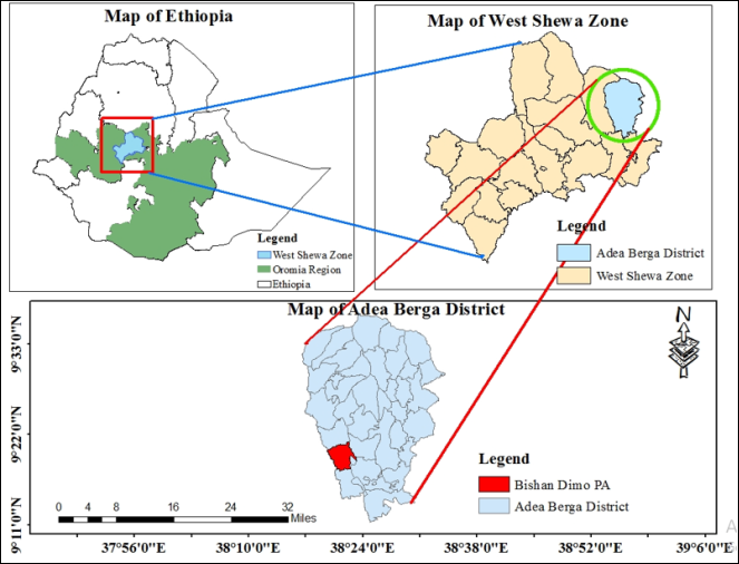
Soil physicochemical properties can be affected by different land use type in Ethiopia. The nutrient content of soil in the three sites was varied based on; soil management systems, organic inputs and other factors. Cognizant of this fact, research was conducted in Bubisa Watershed to evaluate the effect of different land use types and slope on selected physicochemical properties of soil. Accordingly, lands such as; crop, grazing and forest land were nominated and twenty seven (27) core and composite soil samples were collected from 0-20 cm layers. Soil analysis was done and the highest (1.29 g cm-3) bulk density was recorded on the upper slope of crop land and lower (0.99 g cm-3) on the lower slope of forest land. Total porosity and Available water holding capacity were high (60.02%; 172 mm/m) in forest land and lower (49.56%); 152 mm/m) in crop land respectively. Soil pH was high in forest land and low in crop land soils. The result of soil organic carbon and total nitrogen were also high (4.51%; 0.22%) in forest land and low (1.4; 0.15) crop land soils, respectively. Moreover, CEC and basic cations varied across the three sites and high in forest land and low in crop land in the study watershed. Based on the results, it was concluded that forest has high concentration of soil nutrients except bulk density than crop land. As recommendation, studies should be expanded to provide more conclusive recommendation to have qualified; productive soils and estimate the effect of land use types and slope on soil properties for sustainable agricultural productivity.
| Published in | International Journal of Environmental Monitoring and Analysis (Volume 13, Issue 1) |
| DOI | 10.11648/j.ijema.20251301.12 |
| Page(s) | 15-27 |
| Creative Commons |
This is an Open Access article, distributed under the terms of the Creative Commons Attribution 4.0 International License (http://creativecommons.org/licenses/by/4.0/), which permits unrestricted use, distribution and reproduction in any medium or format, provided the original work is properly cited. |
| Copyright |
Copyright © The Author(s), 2025. Published by Science Publishing Group |
Land Use, Slope, Soil Properties
Land use | Slope (%) | Depth (cm) | Particle size distribution (%) | textural class | ||
|---|---|---|---|---|---|---|
Sand | Silt | Clay | ||||
Cultivated land | Upper | 0-20 | 39.24 | 37.74 | 23.02 | L |
Middle | 0-20 | 36.4 | 35.77 | 27.83 | L | |
Lower | 0-20 | 33.22 | 34.43 | 31.83 | CL | |
Grazing land | Upper | 0-20 | 35.3 | 35.28 | 29.42 | CL |
Middle | 0-20 | 32.53 | 35.92 | 31.54 | CL | |
Lower | 0-20 | 31.92 | 37.22 | 30.86 | CL | |
Forest land | Upper | 0-20 | 23.86 | 41.64 | 34.5 | CL |
Middle | 0-20 | 29.06 | 40.3 | 30.64 | CL | |
Lower | 0-20 | 35.28 | 34.95 | 30.29 | CL | |
Land use | SP | Depth (cm) | BD (gcm-3) | TP (%) | FC (%) | PWP (%) | AWHC (mm/m) |
|---|---|---|---|---|---|---|---|
Cultivated land | Upper | 0-20 | 1.29 | 49.56 | 36.3 | 21.1 | 152 |
Middle | 0-20 | 1.23 | 53.59 | 39.5 | 23.7 | 158 | |
Lower | 0-20 | 1.21 | 54.34 | 40.8 | 24.70 | 161 | |
Grazing land | Upper | 0-20 | 1.14 | 56.98 | 40.4 | 24.5 | 159 |
Middle | 0-20 | 1.04 | 57.63 | 42.5 | 26.1 | 164 | |
Lower | 0-20 | 1.01 | 59.76 | 44.7 | 28.0 | 167 | |
Forest land | Upper | 0-20 | 1.15 | 56.73 | 44.8 | 28.5 | 163 |
Middle | 0-20 | 1.05 | 58.38 | 45.5 | 28.7 | 168 | |
Lower | 0-20 | 0.99 | 60.02 | 46.8 | 29.6 | 172 |
Land use | Slope positions | Depth (cm) | pH (H2O) | TN (%) | OC (%) | C: N | Av. P (ppm) |
|---|---|---|---|---|---|---|---|
Cultivated land | Upper | 0-20 | 5.65 | 0.15 | 1.4 | 9.33 | 8.78 |
Middle | 0-20 | 5.75 | 0.17 | 1.76 | 10.35 | 11.01 | |
Lower | 0-20 | 5.86 | 0.21 | 2.43 | 11.57 | 12.94 | |
Grazing land | Upper | 0-20 | 6.27 | 0.17 | 2.23 | 13.12 | 5.08 |
Middle | 0-20 | 6.39 | 0.17 | 2.26 | 13.29 | 6.16 | |
Lower | 0-20 | 6.37 | 0.21 | 3.02 | 14.38 | 6.95 | |
Forest land | Upper | 0-20 | 6.22 | 0.20 | 4.04 | 20.21 | 6.68 |
Middle | 0-20 | 6.38 | 0.21 | 4.34 | 20.34 | 8.01 | |
Lower | 0-20 | 6.51 | 0.22 | 4.51 | 20.53 | 10.28 |
Units | cm | Cmol (+) kg-1 | % | |||||
|---|---|---|---|---|---|---|---|---|
Means | ||||||||
Land use | Slope positions | Depth | CEC | Ca | Mg | K | Na | PBS |
Cultivated land | Upper | 0-20 | 19.47 | 7.51 | 1.6 | 0.79 | 0.13 | 51.52 |
Middle | 0-20 | 20.69 | 8.3 | 2.1 | 0.70 | 0.15 | 54.37 | |
Lower | 0-20 | 22.39 | 8.8 | 2.6 | 0.65 | 0.18 | 54.62 | |
Grazing land | Upper | 0-20 | 21.49 | 8.4 | 2. 61 | 0.84 | 0.14 | 55.79 |
Middle | 0-20 | 21.59 | 8.61 | 2. 62 | 0.66 | 0.16 | 55.81 | |
Lower | 0-20 | 21.66 | 8.89 | 2. 81 | 0.51 | 0.19 | 57.25 | |
Forest land | Upper | 0-20 | 22.85 | 9.29 | 2.86 | 0.87 | 0.21 | 57.90 |
Middle | 0-20 | 23.12 | 9.68 | 2.93 | 0.64 | 0.23 | 58.31 | |
Lower | 0-20 | 23.22 | 9.97 | 2.98 | 0.58 | 0.25 | 59.35 | |
Sa | Si | Cl | BD | TP | pH | TN | OC | Av. P | CEC | Ca | Mg | K | Na | PBS | |
|---|---|---|---|---|---|---|---|---|---|---|---|---|---|---|---|
Sa | 1 | ||||||||||||||
Si | 0.71** | 1 | |||||||||||||
Cl | -0.81** | -0.15 | 1 | ||||||||||||
BD | 0.26 | 0.19 | -0.21 | 1 | |||||||||||
TP | -0.31 | 0.21 | 0.26 | -0.99** | 1 | ||||||||||
pH | -0.44 | 0.07 | 0.56* | -0.76** | 0.79** | 1 | |||||||||
TN | -0.38 | 0.33 | 0.26 | -0.74** | 0.77** | 0.65** | 1 | ||||||||
OC | -0.61** | 0.51* | 0.43 | -0.77** | 0.78** | 0.70*** | 0.81** | 1 | |||||||
Av. P | -0.31 | 0.23 | 0.24 | -0.04 | 0.12 | 0.42 | 0.33 | 0.01 | 1 | ||||||
CEC | -0.43 | 0.03 | 0.58* | -0.54* | 0.58* | 0.73** | 0.67** | 0.67** | 0.02 | 1 | |||||
Ca | -0.41 | 0.04 | 0.54* | -0.57* | 0.59* | 0.72** | 0.67** | 0.78** | 0.05 | 0.93** | 1 | ||||
Mg | -0.36 | 0.51* | 0.42 | -0.31 | 0.33 | 0.53* | 0.16 | 0.07 | 0.11 | 0.49* | 0.42 | 1 | |||
K | 0.13 | 0.41 | 0.38 | -0.87** | 0.11 | 0.34 | 0.07 | 0.02 | 0.15 | 0.59* | 0.45* | 0.81** | 1 | ||
Na | -0.42 | 0.09 | 0.51* | -0.4 | 0.45* | 0.56* | 0.69** | 0.63** | 0.11 | 0.95** | 0.89** | 0.32 | 0.47* | 1 | |
PBS | -0.44 | 0.02 | 0.60** | -0.37 | 0.40 | 0.60** | 0.60** | 0.67** | 0.07 | 0.87** | 0.95** | 0.40 | 0.45* | 0.89** | 1 |
FAO | Food and Agriculture Organization |
MASL | Meter above Sea Level |
IUSS | International Union of Soil Science |
WRB | World Reference Base |
GPS | Geographical Positioning System |
AWHC | Available Water Holding Capacity |
FC | Field Capacity |
PWP | Permanent Wilting Point |
CEC | Cation Exchange Capacity |
CL | Clay loam |
OM | Organic Matter |
BD | Bulk density |
OC | Organic Carbon |
TP | Total Porosity |
SP | Slope Position |
pH | Power of Hydrogen |
TN | Total Nitrogen |
C: N | Carbon to Nitrogen Ratio |
AP | Available Phosphorous |
PBS | Percent Base Saturation |
Sa | Sand |
Si | Silt |
Cl | Clay |
| [1] | Zajıcova, K. and Chuman, T. 2019. Effect of land use on soil chemical properties after 190 years of forest to agricultural land conversion. Soil and Water Research, 14: 121-131. |
| [2] | Aytenew, M. and Kibret, K. 2016. Assessment of soil fertility status at dawja watershed in Enebse SarMidir district, Northwestern Ethiopia. International Journal of Plant & Soil Science, 11: 1-13. |
| [3] | Abera, D. and Kefyalew, A. 2017. Assessement of physicochemical properties of soils as influenced by different land uses in Bedele area in Ilubabor Zone, Southwestern Ethiopia. International Journal of Agriculture Innovations and Research, 5: 319-473. |
| [4] | Berhanu, S. 2016. Assessment of soil fertility status of Vertisols under selected three land uses in GirarJarso District of North Shewa Zone, Oromia National Regional State, Ethiopia. Environmental System Research Journal, 5: 1-16. |
| [5] | Kibebew, K. and Mishra, B. B. 2017. Relevance of organic farming in Ethiopian agriculture: Mission and commitment with second green revolution. Agriculture Research and Technology, 10: 555-799. |
| [6] | Zeleke, G., Agegnehu, G., Abera, D., and Rashid, S. 2010. Fertilizer and soil fertility potential in Ethiopia. Constraints and opportunities for enhancing the system. International Food Policy Research Institute, Addis Ababa, Ethiopia. |
| [7] | Barua, S. K. and Haque, S. M. 2013. Soil characteristics and carbon sequestration potentials of vegetation in degraded hills of Chittagong, Bangladesh. Land Degradation Development, 24: 63-71. |
| [8] | Habtamu, A., Heluf, G., Bobe, B. and Enyew, A. (2014). Fertility status of soils under different land uses at Wujiraba watershed, North-Western Highlands of Ethiopia. Agriculture, Forestry and Fisheries, 3: 410-419. |
| [9] | Munoz, R. M., Jordán, A., Zavala, L. M., De La, R. D., Elmabod, S. K. and Anaya, R. M. 2015. Impact of land use and land cover changes on organic carbon stocks in Mediterranean soils. Land Degradation Development, 26: 168-179. |
| [10] | Adesodun, J. K., Adeyemi, E. F. and Oyegoke, C. O. 2007. Distribution of nutrient elements within water-stable aggregates of two tropical agro ecological soils under different land uses. Soil and Tillage Research, 92: 190-197. |
| [11] | FAO (Food and Agriculture Organization), 2017. Sustaining the future of agriculture in the land of a thousand hills. Food and Agriculture Organization of the United Nations (FAO). |
| [12] | (12] Panwar, N. R., Ramesh, P., Singh, A. B. and Ramana, S. (2010). Influence of organic, chemical, and integrated management practices on soil organic carbon and soil nutrient status under semi-arid tropical conditions in central India Commun. Soil Science and Plant Analysis, 41: 1073-1083. |
| [13] | FAO (Food and Agriculture Organization), 2006. Guidelines for soil description. 4rd Edition, Rome. |
| [14] | IUSS and WRB, 2006. World Reference Base for Soil Resources: A framework for international Classification, Correlation and Communication. International Union of Soil Science, World Soil Resource Reports, No 103. |
| [15] | Eylachew, Z. 2013. Properties of major Agricultural Soils of Ethiopia. Lambert Academic Publishing. |
| [16] | Chapman, D. J., Richard, C., Bishop, W., Michael, H., Barbara, J. and et al. 2009. Natural Resource Damages Associated with Aesthetic and Ecosystem Injuries to Oklahoma’s Illinois River System and Tenkiller Lake. |
| [17] | Bouyoucos, G. J. 1962. Hydrometer method improvement for making particle size analysis of soils. Journal of Agronomy, 54: 179-186. |
| [18] | Soil Survey Staff. 1999. A basic system of soil classification for making and interpreting soil survey. Agricultural Handbook. 436. |
| [19] | Jamison, V. C., Weaver, H. H. and Reed, I. 1950. A hammer driven soil core sampler. Soil Science, 69: 487-496. |
| [20] | Brady, C. N. and Weil, R. R. 2014. Soil Acidity. The nature and properties of soils, USA. 401-442. |
| [21] | Klute, A. 1986. Water retention, Laboratory methods of soil analysis. Physical and Mineralogical Methods. Madison, WI, USA. American Society of Agronomy, 635-662. |
| [22] | Peech, M. 1965. Hydrogen Ion Activity. In Black, C. A., et al., Eds. Methods of Soil Analysis. American Society of Agronomy, 914-926. |
| [23] | Walkley, A. and Black, C. A. 1934. An examination of different methods for determining soil organic matter and the proposed modification by the chromic acid titration method. Soil Science, 37: 29-38. |
| [24] | Jackson, M. L. 1958. Soil chemical analysis. Prenstice Hall, Engle Wood Cliffs. New Jesey, 183-204. |
| [25] | Bray, H. R. and Kurtz L. T. 1945. Determination of organic and available forms of phosphorus in soils. Soil Science, 9: 39-46. |
| [26] | Murphy, J. and Riley, J. P. 1962. A modified single-solution method for the determination of phosphorus in natural waters: Analytical method of Chemical properties, 27: 31-36. |
| [27] | Chapman, H. 1965. Cation exchange capacity by ammonium saturation. Black, C., Ensminger, L and Clark, F. (Ed.), Method of soil analysis, Madison Wisconsin, USA. American Society of Agronomy, 9: 891-901. |
| [28] | Rowell, D. L. 1994. Soil science: Methods and applications. Addison Wesley Longman Limited. England. 350. |
| [29] | Baruah, T. C. and Barthakur, H. P. 1997. A Textbook of Soils Analysis. Vikas Publishing House Private Limited, New Delhi. 256. |
| [30] | R Core Team 2019. A language and environment for statistical computing; R Foundation for Statistical Computing, Vienna, Austria, |
| [31] | Lambin, E. F. and Meyfroidt, P. 2011. Global land use change, economic globalization, and the looming land scarcity. Proceedings of the National Academy of Sciences, 108: 3465-3472. |
| [32] | Dinaburga, G., Lapins, D. and Kopmanis, J. 2010. Differences of soil agrochemical properties in connection with altitude in Winter Wheat. Engineering for Rural Development, 79-84. |
| [33] | Kundu, M. C., Das, T. and Biswas, P. K. et al. 2017. Effect of different land uses on soil organic carbon in new alluvial belt of West Bengal. International Journal of Bioresource, Environment and Agricultural Sciences, 3: 517-520. |
| [34] | Mamo, Y. 2011. Influence of land use systems on selected soil physical and chemical properties at Agedit Watershed, South Gondar Zone, Amhara Regional State. MSc thesis, Haramaya University, Haramaya, Ethiopia. |
| [35] | Eyayu, M., Heluf, G., Tekaliign, M. and Mohammed, A. 2010. Patterns of land use/cover dynamics in the mountain landscape of Tara Gedam and adjacent agro-ecosystem, northwest Ethiopia. Ethiopian Journal of Science, 33: 75-88. |
| [36] | Tellen, V. A. and Yerima, B. P. 2018. Effects of land use change on soil physicochemical properties in selected areas in the North West region of Cameroon. Environmental Systems Research, 7: 3. |
| [37] | Neris, J. 2012. Vegetation and land use effects on soil properties and water infiltration of Andisols in Tenerife. 98: 55-62. |
| [38] | Miheretu, B. A. and Yimer, A. A., 2018. Spatial variability of selected soil properties in relation to land use and slope position in Gelana sub-watershed, Northern highlands of Ethiopia. Physical Geography, 39: 230-245. |
| [39] | Tang, J., Davy, A. J. and Jiang, D. 2016. Effects of excluding grazing on the vegetation and soils of degraded sparse-elm grazing land in the Horqin Sandy Land, China. Agriculture, Ecosystems and Environment, 235: 340-348. |
| [40] | Karltun, E., Tekalign, M., Taye, B., Sam, G. and Selamyihun, K. 2013. Towards improved fertilizer recommendations in Ethiopia; nutrient indices for categorization of fertilizer blends from Ethio-SIS woreda soil inventory data. A discussion paper. |
| [41] | Hazelton, P. and Murphy, B. 2007. Interpreting Soil Test Results. What Do All the Numbers Mean? 2nd Edition. CSIRO Publishing. |
| [42] | Rahman, M. R. and Hossain, M. B. 2015. Changes in land use pattern at ChakariaSundarbans mangrove forest in Bangladesh. Journal of Bangladesh Research Publication, 11: 13-20. |
| [43] | Ezeaku, P. and Eze, F. 2014. Effect of land use in relation to slope position on soil properties in a semi-humid Nsukka area, Southeastern Nigeria. Journal of Agricultural Research, 52: 369-381. |
| [44] | Chemada, M., Kibret, K. and Fite, T. 2017. Influence of different land use types and soil depths on selected soil properties related to soil fertility in Warandhab Area, Horo Guduru Wallaga Zone, Oromia, Ethiopia. International Journal of Environmental Sciences and Natural Resources, 4: 555-634. |
| [45] | Patil, N., Pal, D., Mandal, C. and Mandal, D. 2012. Soil water retention characteristics of vertisols and pedotransfer functions based on nearest neighbor and neural networks approaches to estimate AWC. Journal of Irrigation and Drainage Engineering, 138: 177-184. |
| [46] | Panday, D., Ojha, R. B., Chalise, D., Das, S. and Twanabasu, B. 2019. Spatial variability of soil properties under different land use in the Dang district of Nepal. Cogent Food Agriculture Food Security, 5. |
| [47] | Damiani, M. L. 2016. Spatial trajectories segmentation, trends and challenges. International Workshop on Mobile Geographic Information Systems. |
| [48] | Landon, J. R. 1991. Booker tropical soil manual: A Handbook for soil survey and agricultural land evaluation in the Tropics and Subtropics. Longman Scientific and Technical, Essex, New York. |
| [49] | Mohanty, M., Sinha, N. K., Painuli, D. K., Bandyopadhyay, K. K., Hati, K. M. and Reddy, K. S. et al. 2015. Modelling soil water contents at field capacity and permanent wilting point using artificial neural network for Indian soils. Natural Acadamic Science, 38: 373-377. |
| [50] | Takele, L., Chimdi, A. and Abebaw, A. 2014. Dynamics of soil fertility as influenced by different land use systems and soil depth in West Shoa Zone Gindeberet District Ethiopia. Agricultural Forestry and Fisheries, 3: 489-494. |
| [51] | Lelisa, A. and Abebaw, A. 2016. Study on selected soil physicochemical properties of rehabilitated degraded bare land: the case of Jigessa rehabilitation site, Borana zone, Ethiopia. Global Journal of Advanced Research, 3: 354. |
| [52] | Tekalign M. 1991. Soil, plant, water, fertilizer, animal manure and compost analysis. International Livestock Research Center for Africa, Addis Ababa. |
| [53] | Gazey, C. and Davies, S. 2009. Soil acidity: A guide for WA Farmers and Consultants. Department of Agriculture and Food, Western Australia, Perth. |
| [54] | FAO, (Food and Agriculture Organization), 2006a. Scaling Soil Nutrient Balances. Fertilizer and Plant Nutrition, Bulletin No. 15. FAO, Rome, Italy. |
| [55] | Alemayehu, K. and Sheleme, B. 2013. Effects of different land use systems on selected soil properties in South Ethiopia. Journal of Soil Science and Environmental Management, 4: 107-117. |
| [56] | Siraj, B., Mulugeta, L. and Endalkachew, K. 2015. Soil fertility status and productivity trends along a toposequence: A Case of Gilgel Gibe catchment in Nadda Assendabo watershed, Southwest Ethiopia. International Journal of Environmental Protection and Policy, 3: 137-144. |
| [57] | Yihenew, G. S. and Getachew, A. 2013. Effect of different land use systems on select physicochemical properties of soils in Northwestern Ethiopia. Journal of Agricultural Science, 5: 114-117. |
| [58] | Gelaw, A. M., Singh, B. R. and Lal, R., 2014. Soil organic carbon and total nitrogen stocks under different land uses in a semi-arid watershed in Tigray, Northern Ethiopia. Agriculture, Ecosystems and Environment, 188: 256-263. |
| [59] | Tolessa, T. and Senbeta, F. 2018. The extent of soil organic carbon and total nitrogen in forest fragments of the central highlands of Ethiopia. Journal of Ecology and Environment, 42: 20. |
| [60] | Murphy, H. F. 1968. A report on fertility status and other data on some soils of Ethiopia. Collage of Agriculture, 551. |
| [61] | Gebreslassie, Y. and Ayanna, G. 2013. Effects of different land use systems on selected physico-chemical properties of soils in Applied and Environmental Soil Science, Northwestern Ethiopia. Journal of Agricultural Science, 5: 112. |
| [62] | Tesfahunegn, G. B. 2016. Soil quality indicators response to land use and soil management systems in Northern Ethiopia’s catchment. Land Degradation Development, 27: 438-448. |
| [63] | Tesfaye, M. A., Bravo, F., Peinado, R. Pando, V. and Bravo, A. 2016. Impact of changes in land use, species and elevation on soil organic carbon and total nitrogen in Ethiopian Central Highlands. Geoderma, 261: 70-79. |
| [64] | Moges, A., Dagnachew, M. and Yimer, F. 2013. Land Use Effects on Soil Quality Indicators: A Case Study of Abo Wonsho Southern Ethiopia. Applied and Environmental Soil Science, 20: 1-9. |
| [65] | Lemma, G. and Smit, G. N. 2008. Relationships between plant and soil nutrient status and position in the landscape on Vertisols of Ethiopia. Journal of Plant and Soil Science, 25: 119-126. |
| [66] | Gebreyesus, B. 2013. Soil quality indicators response to land use and soil management systems in Northern Ethiopia’s catchment. Land Degradation Development. |
| [67] | Zhang, K., Dang, H., Tan, S., Cheng, X. and Zhang, Q. 2010. Change in soil organic carbon following the ‘Grain for Green’ programme in China. Land Degradation and Development, 21: 16-28. |
| [68] | Wang, J., Fu, B. Qiu, Y. and Chen, L. 2011. Soil nutrients in relation to land use and landscape position in the semi-arid small catchment on the loess plateau in China. Journal of Arid Environment, 48: 537-550. |
| [69] | Elias, E., 2019. Selected chemical properties of agricultural soils in the Ethiopian highlands: a rapid assessment. South African Journal of Plant and Soil, 36: 153-156. |
| [70] | Cottenie, A. 1980. Soil and plant testing as a basis of fertilizer recommendations. FAO soil bulletin 38/2. Food and Agriculture Organization of the United Nations, Rome. |
| [71] | Abebe, N. and Endalkachew, K. 2012. The contribution of coffee agro-ecosystem to soil fertility in Southwestern Ethiopia. African Journal of Agricultural Research, 7: 74-81. |
| [72] | Muche, M., Kokeb, A. and Molla, E. 2015. Assessing the Physicochemical Properties of Soil under Different Land Use Types. Journal of Environment, Analytical Toxicology, 5: 309. |
| [73] | Kizilkaya, R. and Dengiz, O. 2010. Variation of land use and land cover effects on some soil physicochemical characteristics and soil enzyme activity. Zemdirbyste Agriculture, 97: 15-24. |
| [74] | Abebe, S., Hans, H. and Gete, Z. 2013. A review on soil carbon sequestration in Ethiopia to mitigate land degradation and climate change. Journal of Environment and Earth Science, 3: 187-200. |
| [75] | Achalu, C., Heluf, G., Kibebew, K. and Abi, T. 2012. Status of selected physicochemical properties of soils under different land use systems of Western Oromia, Ethiopia. Journal of Biodiversity and Environmental Sciences, 2: 57-71. |
| [76] | Usmael, M. 2016. Soil fertility assessment and mapping of Becheke Sub-Watershed in Haramaya District of East Hararghe Zone of Oromia Region, Ethiopia. MSc thesis. Haramaya University, Haramaya, Ethiopia. |
| [77] | Kedir, A., Muktar, M. and Kibebew, K. 2016. Soil fertility assessment and mapping of spatial variability at Amareganda-Abajarso SubWatershed, North-Eastern Ethiopia. East African Journal of Sciences, 10: 1-14. |
| [78] | Achalu, C. 2014. Assessment of the severity of acid saturations on soils collected from cultivated lands of East Wollega Zone, Ethiopia. Science, Technology and Arts Research Journal, 3: 42-48. |
| [79] | FAO, (Food and Agriculture Organization), 2006b. Guidelines for Soil Description. Rome, Italy. |
| [80] | Dagne, C. 2016. Soil characteristics in maize based farming system of Western Oromia, Ethiopia. Journal of Energy and Natural Resources, 5: 37-46. |
| [81] | Birhan, A. 2017. Land use/land cover changes and their environmental implications in the Gelana sub-watershed of Northern highlands of Ethiopia. |
| [82] | Bore, G. and Bedadi, B. 2015. Impacts of land use types on selected soil physicochemical properties of Loma Woreda, Dawuro Zone, Southern Ethiopia. Science, Technology and Arts Research Journal, 4: 40-48. |
| [83] | Getachew, F. and Heluf, G. 2007. Characterization and fertility status of the soils of Ayehu Research Substation, Northwestern Highlands of Ethiopia. East African Journal of Sciences, 1: 160-169. |
| [84] | Havlin, J. L., Beaton, J. D., Tisdale, S. L. and Nelson, W. L. 2009. Soil Fertility and Fertilizers: An Introduction to Nutrient Management, USA. |
| [85] | Abreha, K., Heluf, G., Tekalign, M. and Kibebew, K. (2012). Impact of altitude and land use type on some physical and chemical properties of acidic soils in Tsegede highlands, northern Ethiopia. Open Journal of Soil Science, 2: 223-233. |
APA Style
Lemma, A., Wakgari, T., Kebede, G. (2025). Effect of Land Use Types and Slope on Selected Soil Physicochemical Properties in Bubisa Watershed, Adea Berga District, Central Ethiopia. International Journal of Environmental Monitoring and Analysis, 13(1), 15-27. https://doi.org/10.11648/j.ijema.20251301.12
ACS Style
Lemma, A.; Wakgari, T.; Kebede, G. Effect of Land Use Types and Slope on Selected Soil Physicochemical Properties in Bubisa Watershed, Adea Berga District, Central Ethiopia. Int. J. Environ. Monit. Anal. 2025, 13(1), 15-27. doi: 10.11648/j.ijema.20251301.12
AMA Style
Lemma A, Wakgari T, Kebede G. Effect of Land Use Types and Slope on Selected Soil Physicochemical Properties in Bubisa Watershed, Adea Berga District, Central Ethiopia. Int J Environ Monit Anal. 2025;13(1):15-27. doi: 10.11648/j.ijema.20251301.12
@article{10.11648/j.ijema.20251301.12,
  author = {Ajema Lemma and Tesfaye Wakgari and Gizachew Kebede},
  title = {Effect of Land Use Types and Slope on Selected Soil Physicochemical Properties in Bubisa Watershed, Adea Berga District, Central Ethiopia},
  journal = {International Journal of Environmental Monitoring and Analysis},
  volume = {13},
  number = {1},
  pages = {15-27},
  doi = {10.11648/j.ijema.20251301.12},
  url = {https://doi.org/10.11648/j.ijema.20251301.12},
  eprint = {https://article.sciencepublishinggroup.com/pdf/10.11648.j.ijema.20251301.12},
  abstract = {Soil physicochemical properties can be affected by different land use type in Ethiopia. The nutrient content of soil in the three sites was varied based on; soil management systems, organic inputs and other factors. Cognizant of this fact, research was conducted in Bubisa Watershed to evaluate the effect of different land use types and slope on selected physicochemical properties of soil. Accordingly, lands such as; crop, grazing and forest land were nominated and twenty seven (27) core and composite soil samples were collected from 0-20 cm layers. Soil analysis was done and the highest (1.29 g cm-3) bulk density was recorded on the upper slope of crop land and lower (0.99 g cm-3) on the lower slope of forest land. Total porosity and Available water holding capacity were high (60.02%; 172 mm/m) in forest land and lower (49.56%); 152 mm/m) in crop land respectively. Soil pH was high in forest land and low in crop land soils. The result of soil organic carbon and total nitrogen were also high (4.51%; 0.22%) in forest land and low (1.4; 0.15) crop land soils, respectively. Moreover, CEC and basic cations varied across the three sites and high in forest land and low in crop land in the study watershed. Based on the results, it was concluded that forest has high concentration of soil nutrients except bulk density than crop land. As recommendation, studies should be expanded to provide more conclusive recommendation to have qualified; productive soils and estimate the effect of land use types and slope on soil properties for sustainable agricultural productivity.},
 year = {2025}
}
TY  - JOUR
T1  - Effect of Land Use Types and Slope on Selected Soil Physicochemical Properties in Bubisa Watershed, Adea Berga District, Central Ethiopia
AU  - Ajema Lemma
AU  - Tesfaye Wakgari
AU  - Gizachew Kebede
Y1  - 2025/01/22
PY  - 2025
N1  - https://doi.org/10.11648/j.ijema.20251301.12
DO  - 10.11648/j.ijema.20251301.12
T2  - International Journal of Environmental Monitoring and Analysis
JF  - International Journal of Environmental Monitoring and Analysis
JO  - International Journal of Environmental Monitoring and Analysis
SP  - 15
EP  - 27
PB  - Science Publishing Group
SN  - 2328-7667
UR  - https://doi.org/10.11648/j.ijema.20251301.12
AB  - Soil physicochemical properties can be affected by different land use type in Ethiopia. The nutrient content of soil in the three sites was varied based on; soil management systems, organic inputs and other factors. Cognizant of this fact, research was conducted in Bubisa Watershed to evaluate the effect of different land use types and slope on selected physicochemical properties of soil. Accordingly, lands such as; crop, grazing and forest land were nominated and twenty seven (27) core and composite soil samples were collected from 0-20 cm layers. Soil analysis was done and the highest (1.29 g cm-3) bulk density was recorded on the upper slope of crop land and lower (0.99 g cm-3) on the lower slope of forest land. Total porosity and Available water holding capacity were high (60.02%; 172 mm/m) in forest land and lower (49.56%); 152 mm/m) in crop land respectively. Soil pH was high in forest land and low in crop land soils. The result of soil organic carbon and total nitrogen were also high (4.51%; 0.22%) in forest land and low (1.4; 0.15) crop land soils, respectively. Moreover, CEC and basic cations varied across the three sites and high in forest land and low in crop land in the study watershed. Based on the results, it was concluded that forest has high concentration of soil nutrients except bulk density than crop land. As recommendation, studies should be expanded to provide more conclusive recommendation to have qualified; productive soils and estimate the effect of land use types and slope on soil properties for sustainable agricultural productivity.
VL  - 13
IS  - 1
ER  -
Oromia Agricultural Research Institute, Fitche Agricultural Research Center, Fitche, Ethiopia
Information