Abstract
This research investigates the physical land suitability for teff (Eragrostis tef) cultivation in Mieso District, Oromia National Regional State, Ethiopia, using Geographic Information Systems (GIS) and Remote Sensing (RS) techniques. Teff is a staple crop of major economic and food security importance in Ethiopia; however, its productivity is strongly influenced by variations in environmental and agro-ecological conditions. Therefore, identifying suitable land for teff cultivation is essential for sustainable agricultural planning and improved crop yields. The study integrates multiple biophysical factors that significantly affect teff growth, including soil type, altitude, slope, rainfall, and temperature. Spatial datasets were collected from satellite imagery, digital elevation models, soil databases, and meteorological records. These datasets were processed and analyzed using GIS tools. A multi-criteria decision-making (MCDM) approach, specifically a weighted overlay analysis, was applied to evaluate and classify land suitability based on the relative importance of each factor. The results indicate that areas characterized by gentle slopes, favorable elevations, nutrient-rich soils, and suitable climatic conditions exhibit high to moderate suitability for teff cultivation. In particular, regions receiving annual rainfall between 800 and 1200 mm and experiencing moderate temperatures were identified as the most suitable zones. Conversely, areas with steep slopes, poor soil conditions, or unfavorable climatic characteristics were classified as marginally suitable or unsuitable. The findings demonstrate a strong relationship between agro-ecological conditions and teff productivity in the study area. This research provides valuable spatial information that can support farmers, planners, and policymakers in optimizing land use decisions. Ultimately, the study contributes to enhancing agricultural productivity, promoting sustainable land management, and strengthening food security in the Mieso District and similar agro-ecological settings.
Keywords
GIS, Remote Sensing, Teff, Land Suitability Analysis, Multi-Criteria Decision Making
1. Introduction
Globally, agriculture has the capacity to outpace population growth in food supply, a trend expected to continue
| [18] | John, et al. (2014). Areas that have annual rainfall ranges from 800 to 1200 mm are most suitable for teff production. |
[18]
. However, food security concerns are rising in Africa, particularly sub-Saharan Africa,
| [13] | FAO. (1985). Guidelines: Land evaluation for irrigated agriculture. FAO Soils Bulletin No. 55. |
[13]
. despite a generally positive global outlook
| [16] | Hemathilake, R. K., & Gunathilake, M. B. (2022). Globally, agriculture has the capacity to outpace population growth in food supply. |
[16]
. The increasing world population necessitates a corresponding boost in food production
| [25] | Schnika, N. (2009). The state of food insecurity in the world. Actividad Dietetica, 13. |
[25]
and
| [10] | Bruinsma, J. (2017). World agriculture: towards 2015/2030: an FAO study. Routledge. |
[10]
.
Teff, an essential cereal grain in Ethiopia, was domesticated between 4000 and 1000 BC, with
Eragrostis pilosa identified as its wild ancestor and the Tigray region as its likely domestication site
| [4] | Asefa, K., Assefa, H., & Eshetu, B. (2020). Genotype by environment interaction and stability analysis of teff (Eragrostis tef) genotypes for grain yield in Ethiopia. International Journal of Agronomy, 2020. https://doi.org/10.1155/2020/2572615 |
[4]
. While there is debate over the origin of ancient Egyptian teff seeds, Ethiopia remains the recognized center for teff's development
. Current research aims to improve teff's yield and climate resilience through advanced genomic and breeding techniques
.
Teff is exported to different countries, mainly to the Middle East, North America and to many European countries, where Ethiopians or Ethiopian origin live.
| [14] | FAO. (1993). Guidelines for land-use planning. Rome. |
[14]
in the Oromia region of Ethiopia total of 1.4 million hectares of land were covered by teff in the 2018/19 cropping season
| [9] | Birhan, A. (2012). Agronomic and economic effects of blended fertilizers under planting method on yield and yield components of teff in Wereda Laelay Maychew, Central Tigray, Ethiopia. |
[9]
From this, 26.9 million quintals production was produced.
| [11] | FAO. (1976). A framework for land evaluation. FAO Soils Bulletin No. 32. Rome. |
[11]
At the regional level and 6.86 million rural households of Ethiopia were engaged in Teff cultivation
| [24] | Powell, H., Mihalas, S., Onwuegbuzie, A. J., Suldo, S., & Daley, C. E. (2008). Mixed methods research in school psychology. Psychology in the Schools, 45(4), 291-309.
https://doi.org/10.1002/pits.20314 |
[24]
.
Teff is a vital crop in Ethiopia, facing challenges in production, particularly in the Mieso District of the West Hararghe Zone. The region's diverse geography and climate, along with varied land use,
| [15] | Gebremariam, M. M., Zarnkow, M., & Becker, T. (2014). Teff (Eragrostis tef) as a raw material for malting, brewing and manufacturing of gluten-free foods and beverages: A review. Journal of Food Science and Technology, 51(11), 2881-2895.
https://doi.org/10.1007/s13197-012-0745-5 |
[15]
complicate the identification of suitable areas for cultivation
| [13] | FAO. (1985). Guidelines: Land evaluation for irrigated agriculture. FAO Soils Bulletin No. 55. |
[13]
. Traditional land suitability assessments often lack the necessary detail and accuracy
. Despite its importance for food security and economic stability, there is a gap in utilizing Geographic Information Systems (GIS) and Remote Sensing for analysing land suitability. Current studies frequently overlook advanced spatial techniques to evaluate factors like soil quality and climate conditions, which are essential for teff farming
| [7] | Bell, R. A. (2015, August 17). Teff is a healthy wheat alternative. Michigan State University. |
[7]
.
As climate change impacts agriculture, there is an urgent need for a systematic approach that employs modern technologies
| [19] | Kassaye, K., Belay, A., & Wubie, E. (2018). Agro-ecological zones and their potential for teff production in Ethiopia. World Journal of Agricultural Research, 6(3), 73-79.
https://doi.org/10.12691/wjar-6-3-1 |
[19]
. This study seeks to address this gap by using GIS and Remote Sensing to evaluate land suitability for optimal teff production in Mieso District, offering valuable insights for stakeholders.
2. Methods and Materials
2.1. Description of Study Area
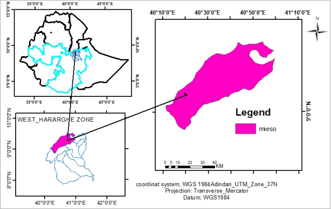
Mieso is a woreda located in the Oromia Region of Ethiopia. As part of the West Hararghe Zone, Mieso is bordered to the south by Guba Koritha, to the west by the Afar Region, to the north by the Somali Region, to the east by Doba, and to the southeast by Chiro Zuria Woreda.
Figure 1. Location Map of Study Area.
Mieso, situated at altitudes between 1,107 and 3,106 meters, boasts its highest point, Mount Asabot, at 1,523 meters. It features the Beke River, with 11.5% of its land arable—10.7% dedicated to annual crops. Additionally, 23.7% is potentially cultivable with water access, while 8.9% is pasture and 28.7% is forest. Key cash crops include sesame and haricot beans. The area houses the Monastery of Asabot Selassie, 20 kilometers northeast of Asabot, and is accessible via the Ethio-Djibouti Railways. The dry season lasts from November to February, peaking in dryness during December and January. Mieso's primary soil types are nutrient-rich, including Haplic Yermosols and Chromic Cambisols, with soil depth varying from shallow on steep slopes to 4 meters on gentler ones, making it highly productive for both cereal and perennial crops
| [25] | Schnika, N. (2009). The state of food insecurity in the world. Actividad Dietetica, 13. |
[25]
.
2.2. Research Design
This study utilized a partially mixed sequential dominant status research design, incorporating both quantitative and qualitative approaches
| [24] | Powell, H., Mihalas, S., Onwuegbuzie, A. J., Suldo, S., & Daley, C. E. (2008). Mixed methods research in school psychology. Psychology in the Schools, 45(4), 291-309.
https://doi.org/10.1002/pits.20314 |
[24]
. According to in this design, the quantitative phase takes precedence and occurs first, followed by the qualitative phase. The two methods are integrated during the data interpretation stage, with emphasis placed on the quantitative data throughout the study.
Material used
Table 1. Material used.
Software Used | Purpose |
ERDAS | Employed for image processing and classification. |
Microsoft Excel | Utilized for organizing and managing numerical data. |
ArcGIS Software | Applied for comprehensive data management and analysis. |
2.3. Sources of Data
All data are downloading some global and regional spatial data provender.
Table 2. Data source.
Source | USGS | FAO | CHRS | DIVAGIS |
Data | LULC &temperature | Soil type | rainfall | Elevation and slope |
Date | 1/2/2024 | 1978 | 2021 | 2024 |
2.4. Methods of Data Collection
Field Surveys: Conducted on-site assessments to gather primary data on soil properties, land use patterns, and local agricultural practices.
Satellite Imagery: Utilized high-resolution satellite images (such as Landsat) for land use/land cover classification and to assess vegetation health and distribution in the study area.
Remote Sensing Technologies: Employed remote sensing tools to capture and analyze environmental variables, such as temperature and rainfall patterns, relevant to teff cultivation.
Digital Elevation Model (DEM): Acquired a DEM for the Mieso District to analyze topographical features and derive slope and elevation data.
Existing Databases: Gathered secondary data from agricultural databases and government reports to supplement field data and provide context for the analysis.
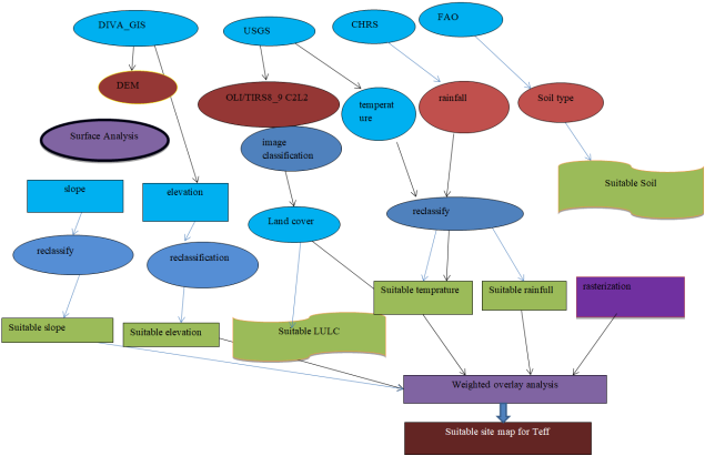
2.5. Data Analysis
Geographic Information Systems (GIS): Integrated and analyzed spatial data using GIS software to perform overlay analyses, identify suitable land areas, and visualize results.
Image Classification: Processed satellite imagery using classification techniques to create a land use/land cover map, which informs suitability assessments for teff production.
Surface Analysis: Derived slope and other topographical features from the DEM to assess their impact on land suitability for teff cultivation.
Soil Classification and Analysis: Converted soil type shapefiles into grid formats to evaluate soil characteristics relevant to teff production.
Multi-Criteria Evaluation (MCE): Applied multi-criteria evaluation techniques to combine various parameters (e.g., soil quality, climate, and slope) and create a comprehensive land suitability model for teff cultivation.
Statistical Analysis: Conducted statistical tests to validate the findings and ensure the reliability of the results in the context of agricultural suitability.
2.6. Multi-Criteria Decision-Making Rules (MCDM)
After preparing all the model parameters compatible to the suitability model, estimating weights for the model parameters is next step. Running a suitability model requires to estimate weights for each individual model parapets.. Before the model parameters are merged to the weighted overlay analysis, the input model parameters are first converted in to a raster data model. During the conversion of the vector data in to a raster to make the data layers compatible for the raster analysis a 30 m cell size is taken on the basis of the DEM (Digital Elevation Model) resolution.
Therefore, all the input parameters are resampled to 30 m raster cell size resolution. In addition, to make the parameters in to a uniform scale value for the overlay analysis, each parameter is reclassified in to 4 suitability classes ranging from 1 to 4 on the basis of their importance to the suitability model objective, where 1 implies un suitable while 4 represents the most suitable part of the study area. After each model parameter is reclassified in to a similar scale value, finally each model parameter weighted using.
GIS methodologies of Multi criteria Decision Making Rules in particular ranking methods. Finally, the model is run in a GIS environment in a spatial analysis tool.
Analytic hierarchy process (AHP),
Analytical hierarchy process, is a structured technique for organizing and analysing complex decisions, based on mathematics and psychology.
Pairwise comparison matrix
Table 3. Pairwise comparison matrix.
| Rainfall | Soil | Temperature | LULC | Slope | Elevation | Criteria Weight |
Rainfall | 1 | 2 | 3 | 5 | 7 | 2 | 0.20 |
Soil | ½ | 1 | 6 | 3 | 7 | 8 | 0.19 |
Temperature | 1/3 | 1/6 | 1 | 4 | 7 | 9 | 0.18 |
LULC | 1/5 | 1/3 | ¼ | 1 | 5 | 6 | 0.17 |
Slope | 1/7 | 1/7 | 1/7 | 1/5 | 1 | 2 | 0.16 |
Elevation | ½ | 1/8 | 1/9 | 1/6 | 1/2 | 1 | 0.15 |
The consistency ration should be less than 0.1, then only the pair wise comparison satisfies
Figure 2. Methodological flow chart.
3. Results and Discussion
3.1 Results
In executing the suitability model, the following parameters were utilized: Digital Elevation Model (DEM), slope, rainfall, temperature, soil classification, and land use/land cover. Each parameter layer was reclassified to a new evaluation scale ranging.
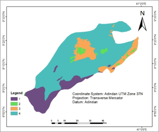
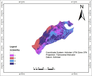
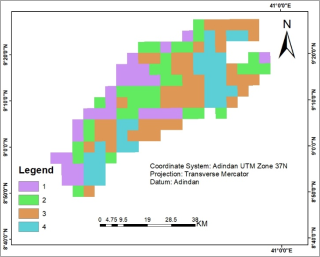
3.1.1. Soil Classification
Below figures suitable land analysis 1 represents "unsuitable," 2 indicates "low suitability," 3 signifies "moderate suitability," and 4 denotes "high suitability. The figure below illustrates the suitable land analysis for teff cultivation, employing a classification system where 1 represents "unsuitable," 2 indicates "low suitability," 3 signifies "moderate suitability," and 4 denotes "high suitability."
Similar studies have utilized comparable classification schemes to assess land suitability for various crops. For instance,
| [23] | Murphy, D. J. (2007). People, plants, and genes: The story of crops and humanity. Oxford University Press. |
[23]
. conducted a land suitability analysis for teff and applied a similar four-tiered scale to categorize lands.
Figure 3. Reclassified Soil types.
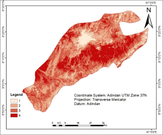
3.1.2. Digital Elevation Model (DEM)
The DEM shows an elevation range of very low altitude 855 meter above sea level and high peaks up to 2293 meter.
Elevation is also reclassified in to 4 classes with evaluation scale 1 to 4 where 1 represents the unsuitability and 4 the highest suitability. Below figure (map) result revealed as reclassified DEM 1 indicate unsuitable, 2 low suitable, 3 moderate suitable and 4 highly suitable.
Figure 4. Reclassified Digital Elevation Model.
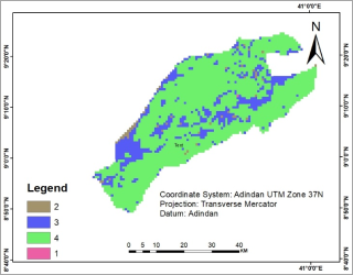
3.1.3. Slope
Slope is derived from DEM of the study area in a GIS platform by using surface analysis in ArcGIS 10.3 software. The resulting slope derived from digital elevation model of the Mieso area comprises slope steepness ranging 0 to 60 degrees. This value is again reclassified in to four slope classes so as to make the slope compatible in the suitability modeling with other model parameters.
Figure 5. Reclassified Slope.
3.1.4. Temperature
Temperature is the most important factor that determines the production of teff with water availability at the optimum satisfaction. Areas that have the mean temperature between 10 and 27°C are suitable for optimal agronomical environment for teff cultivation.
It has the highest mean temperature of 18°C and the lowest mean temperature is about 15°C and also this temperature is reclassified again like other parameters to get the most suitable temperature for teff production and make it compatible with weighted overlay analysis.
Figure 6. Reclassified temperature.
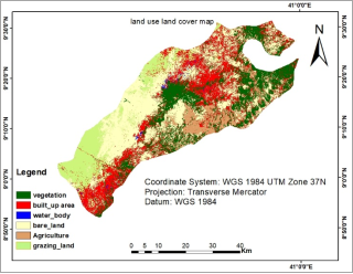
3.1.5. Land Use Land Cover
The land cover is taken as one major parameter that affects the suitability modeling in the present study area. Land use is the way in which, and the purpose for which, human beings employ the land and its resources
| [1] | Alemayehu, A. (2006). Land use is the way in which, and the purpose for which, human beings employ the land and its resources. |
[1]
. I was doing land use land cover classification by comparing google earth.
Figure 7. Land Use Land Cover map.
In the land suitability analysis model, some areas such as water body, urban built-up area, are unsuitable vegetation is low suitable, grazing land moderate suitable and the remain are high suitable are Reclassified. The Land Use Land Cover is reclassified in to 4 suitability classes ranging from 1 to 4 on the basis of their importance to the suitability model objective, where 1 implies un suitable while 4 represents the most suitable part of the study area.
Figure 8. Reclassified Land Use Land Cover.
3.1.6. Rainfall
One of the single most important factor that determines teff production is rainfall availability. Areas that “have annual rainfall ranges from 800 to 1200 mm are the most advisable place for the production of teff”
. As a result, the amount of rainfall for teff production in the study area is identified by mapping mean annual rainfall.
Like other model parameters, the rainfall map is reclassified in to 4 suitability classes ranging from 1 to 4 where 4 indicates “the most suitable” and 1 “the un suitable” areas. Then the reclassified rainfall map would be compatible to run the weighted overlay analysis of the suitability model. Under this study, choosing suitable site for optimal teff production implies assessing such things as land use land cover, slope, soil type, rainfall, elevation and temperature. This information exists in different raster layers with different value scales; therefore, each data layer is reclassified in to uniform scale value to obtain meaningful result.
Figure 9. Reclassified Rainfall.
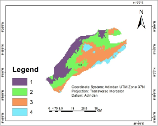
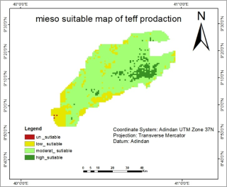
The final result of the study is based on the spatial modelling as the result shows (
Figure 10) areas with enough amounts of rainfall, fertile soil types, optimum temperature, and with suitable elevation type, gentle slope, and also land use land cover types with cultivated areas are identified as the most suitable areas for teff production. Additionally, areas with enough rainfall, moderate fertile soil types, optimum temperature, moderate elevation and moderate slope gradient and also with land use classes such as bare land are grouped as moderately suitable areas for teff production in Mieso area.
Figure 10. Suitability Map for teff production.
3.2. Discussion
This study evaluated the physical land suitability for teff crop production in Mieso District using GIS and remote sensing. Key findings show that elevation, rainfall, temperature, soil type, and land use significantly impact suitability, consistent with
| [6] | Ayele, A. A., Tekalign, A., & Seid, K. (2019). Site suitability analysis for teff (Eragrostis tef) cultivation using GIS-based multi-criteria decision analysis in Gurage Zone, Ethiopia. Journal of Geographic Information System, 11(02), 184.
https://doi.org/10.4236/jgis.2019.112012 |
[6]
. The integration of GIS and remote sensing enhances decision-making, supporting
| [2] | Alemu, T., Yitaferu, B., & Belete, M. (2021). Site suitability analysis for teff (Eragrostis tef) cultivation using GIS and AHP approach in Gog district, southwestern Ethiopia. Journal of Land Use Science, 1-21.
https://doi.org/10.1080/1747423X.2021.1874657 |
[2]
.'s assertion on the importance of spatial analysis.
The study classified land into four suitability levels—unsuitable, low, moderate, and high aligning with
| [23] | Murphy, D. J. (2007). People, plants, and genes: The story of crops and humanity. Oxford University Press. |
[23]
. and allowing stakeholders to prioritize interventions. Specific elevation ranges (1,107 to 3,106 meters) significantly affect yield, corroborating
| [21] | Mekonnen, T., & Tadesse, M. (2016). Land suitability analysis for teff cultivation. |
[21]
. Optimal rainfall is crucial, as noted by
, emphasizing the need for effective water management.
Soil quality, especially nutrient-rich types like Haplic Yermosols, enhances productivity, echoing
| [17] | Ingram, A. L., & Doyle, J. J. (2003). The origin and evolution of Eragrostis tef and related polyploids. American Journal of Botany, 90(1), 116-122.
https://doi.org/10.3732/ajb.90.1.116 |
[17]
. The findings offer practical guidance for resource allocation and best practices for farmers and policymakers, similar to
| [12] | FAO. (1978). La producción de soja en los trópicos. FAO. |
[12]
. However, the study focused mainly on physical attributes, neglecting socioeconomic factors, a limitation highlighted by
| [8] | Beyene, F. (2016). Land use change and determinants of land management: Experience of pastoral and agro-pastoral herders in eastern Ethiopia. Journal of Arid Environments, 125, 56-63.
https://doi.org/10.1016/j.jaridenv.2015.10.001 |
[8]
. Future research should include broader variables such as market access and community engagement, and leverage advancements in remote sensing for improved accuracy
| [25] | Schnika, N. (2009). The state of food insecurity in the world. Actividad Dietetica, 13. |
[25]
.
4. Conclusion and Recommendations
This study successfully evaluated the physical land suitability for teff crop production in Mieso District using GIS and remote sensing technologies. Key findings indicate that elevation, rainfall, temperature, soil type, and land use are crucial factors influencing agricultural suitability. The integration of these technologies not only enhances the accuracy of land assessments but also supports informed decision-making for optimizing agricultural practices.
4.1. Conclusion
The research highlights specific areas suitable for teff cultivation, providing valuable insights for stakeholders. The classification of land into four suitability levels facilitates targeted agricultural interventions, which can lead to improved productivity and sustainable land use in the region. However, the focus on physical factors necessitates caution, as socioeconomic variables remain critical in effective land management.
4.2. Recommendations
Incorporate Socioeconomic Factors: Future research should integrate socioeconomic data, such as market access and community engagement, to provide a more comprehensive understanding of land suitability.
Enhance Water Management Strategies: Implement effective water management techniques to ensure sufficient rainfall utilization, as it is essential for optimizing teff production.
Promote Soil Conservation Practices: Advocate for sustainable soil management strategies, particularly in nutrient-rich areas, to maintain soil fertility and enhance agricultural resilience.
Leverage Advanced Technologies: Utilize advancements in remote sensing and GIS to refine land suitability assessments, ensuring higher resolution and accuracy in future studies.
Stakeholder Engagement: Actively involve farmers, policymakers, and local communities in land management planning to foster a collaborative approach to agricultural development.
Abbreviations
AHP | Analytic Hierarchy Process |
DEM | Digital Elevation Model |
FAO | Food and Agriculture Organization |
GIS | Geographic Information System |
MCDM | Multi-Criteria Decision-Making |
RS | Remote Sensing |
Acknowledgments
Authors are grateful to I would like to thank the peoples of Meiso district, agricultural development agents, and local administrators of the study area for their kindness and cooperation during the fieldwork. Finally, author is also thankful to the USGS for offering free access to satellite imageries of the study area.
Author Contributions
Mekonen Hunde Geletu is the sole author. The author read and approved the final manuscript.
Funding
There no one fund rise for this research every think is covered by researcher.
Data Availability Statement
The datasets used and/or analyzed during the current study are available from the corresponding author on reasonable request.
Conflicts of Interest
The authors declare no conflicts of interest.
References
| [1] |
Alemayehu, A. (2006). Land use is the way in which, and the purpose for which, human beings employ the land and its resources.
|
| [2] |
Alemu, T., Yitaferu, B., & Belete, M. (2021). Site suitability analysis for teff (Eragrostis tef) cultivation using GIS and AHP approach in Gog district, southwestern Ethiopia. Journal of Land Use Science, 1-21.
https://doi.org/10.1080/1747423X.2021.1874657
|
| [3] |
Assefa, K., Ketema, S., & Tefera, H. (2001). Characteristics, production constraints and opportunities for teff in Ethiopia. Plant Breeding, 120(3), 241-246.
https://doi.org/10.1046/j.1439-0523.2001.00588.x
|
| [4] |
Asefa, K., Assefa, H., & Eshetu, B. (2020). Genotype by environment interaction and stability analysis of teff (Eragrostis tef) genotypes for grain yield in Ethiopia. International Journal of Agronomy, 2020.
https://doi.org/10.1155/2020/2572615
|
| [5] |
Ayana, A., & Bekele, E. (1997). Geographic patterns of morphological variation in teff (Eragrostis tef). Hereditas, 127(2), 163-168.
https://doi.org/10.1111/j.1601-5223.1997.00163.x
|
| [6] |
Ayele, A. A., Tekalign, A., & Seid, K. (2019). Site suitability analysis for teff (Eragrostis tef) cultivation using GIS-based multi-criteria decision analysis in Gurage Zone, Ethiopia. Journal of Geographic Information System, 11(02), 184.
https://doi.org/10.4236/jgis.2019.112012
|
| [7] |
Bell, R. A. (2015, August 17). Teff is a healthy wheat alternative. Michigan State University.
|
| [8] |
Beyene, F. (2016). Land use change and determinants of land management: Experience of pastoral and agro-pastoral herders in eastern Ethiopia. Journal of Arid Environments, 125, 56-63.
https://doi.org/10.1016/j.jaridenv.2015.10.001
|
| [9] |
Birhan, A. (2012). Agronomic and economic effects of blended fertilizers under planting method on yield and yield components of teff in Wereda Laelay Maychew, Central Tigray, Ethiopia.
|
| [10] |
Bruinsma, J. (2017). World agriculture: towards 2015/2030: an FAO study. Routledge.
|
| [11] |
FAO. (1976). A framework for land evaluation. FAO Soils Bulletin No. 32. Rome.
|
| [12] |
FAO. (1978). La producción de soja en los trópicos. FAO.
|
| [13] |
FAO. (1985). Guidelines: Land evaluation for irrigated agriculture. FAO Soils Bulletin No. 55.
|
| [14] |
FAO. (1993). Guidelines for land-use planning. Rome.
|
| [15] |
Gebremariam, M. M., Zarnkow, M., & Becker, T. (2014). Teff (Eragrostis tef) as a raw material for malting, brewing and manufacturing of gluten-free foods and beverages: A review. Journal of Food Science and Technology, 51(11), 2881-2895.
https://doi.org/10.1007/s13197-012-0745-5
|
| [16] |
Hemathilake, R. K., & Gunathilake, M. B. (2022). Globally, agriculture has the capacity to outpace population growth in food supply.
|
| [17] |
Ingram, A. L., & Doyle, J. J. (2003). The origin and evolution of Eragrostis tef and related polyploids. American Journal of Botany, 90(1), 116-122.
https://doi.org/10.3732/ajb.90.1.116
|
| [18] |
John, et al. (2014). Areas that have annual rainfall ranges from 800 to 1200 mm are most suitable for teff production.
|
| [19] |
Kassaye, K., Belay, A., & Wubie, E. (2018). Agro-ecological zones and their potential for teff production in Ethiopia. World Journal of Agricultural Research, 6(3), 73-79.
https://doi.org/10.12691/wjar-6-3-1
|
| [20] |
Mekonnen, T., & Bewket, W. (2018). GIS-based land suitability assessment for teff in the highlands of Ethiopia. Applied Geography, 98, 1-11.
https://doi.org/10.1016/j.apgeog.2018.07.002
|
| [21] |
Mekonnen, T., & Tadesse, M. (2016). Land suitability analysis for teff cultivation.
|
| [22] |
Miretu, A., & Abebaw, L. (2020). Economic profitability, farmers’ preference and constraints in Northeast Amhara, Ethiopia. Cogent Food & Agriculture, 6(1).
https://doi.org/10.1080/23311932.2020.1733334
|
| [23] |
Murphy, D. J. (2007). People, plants, and genes: The story of crops and humanity. Oxford University Press.
|
| [24] |
Powell, H., Mihalas, S., Onwuegbuzie, A. J., Suldo, S., & Daley, C. E. (2008). Mixed methods research in school psychology. Psychology in the Schools, 45(4), 291-309.
https://doi.org/10.1002/pits.20314
|
| [25] |
Schnika, N. (2009). The state of food insecurity in the world. Actividad Dietetica, 13.
|
Cite This Article
-
APA Style
Geletu, M. H. (2026). GIS and Remote Sensing-Driven Physical Land Suitability Analysis for Optimal Teff Crop Production: A Case Study of Mieso District, West Hararghe Zone, Ethiopia. International Journal of Information and Communication Sciences, 11(1), 13-21. https://doi.org/10.11648/j.ijics.20261101.12
 Copy
|
Copy
|
 Download
ACS Style
Geletu, M. H. GIS and Remote Sensing-Driven Physical Land Suitability Analysis for Optimal Teff Crop Production: A Case Study of Mieso District, West Hararghe Zone, Ethiopia. Int. J. Inf. Commun. Sci. 2026, 11(1), 13-21. doi: 10.11648/j.ijics.20261101.12
Copy
|
Download
AMA Style
Geletu MH. GIS and Remote Sensing-Driven Physical Land Suitability Analysis for Optimal Teff Crop Production: A Case Study of Mieso District, West Hararghe Zone, Ethiopia. Int J Inf Commun Sci. 2026;11(1):13-21. doi: 10.11648/j.ijics.20261101.12
Copy
|
Download
-
@article{10.11648/j.ijics.20261101.12,
  author = {Mekonen Hunde Geletu},
  title = {GIS and Remote Sensing-Driven Physical Land Suitability Analysis for Optimal Teff Crop Production: A Case Study of Mieso District, West Hararghe Zone, Ethiopia},
  journal = {International Journal of Information and Communication Sciences},
  volume = {11},
  number = {1},
  pages = {13-21},
  doi = {10.11648/j.ijics.20261101.12},
  url = {https://doi.org/10.11648/j.ijics.20261101.12},
  eprint = {https://article.sciencepublishinggroup.com/pdf/10.11648.j.ijics.20261101.12},
  abstract = {This research investigates the physical land suitability for teff (Eragrostis tef) cultivation in Mieso District, Oromia National Regional State, Ethiopia, using Geographic Information Systems (GIS) and Remote Sensing (RS) techniques. Teff is a staple crop of major economic and food security importance in Ethiopia; however, its productivity is strongly influenced by variations in environmental and agro-ecological conditions. Therefore, identifying suitable land for teff cultivation is essential for sustainable agricultural planning and improved crop yields. The study integrates multiple biophysical factors that significantly affect teff growth, including soil type, altitude, slope, rainfall, and temperature. Spatial datasets were collected from satellite imagery, digital elevation models, soil databases, and meteorological records. These datasets were processed and analyzed using GIS tools. A multi-criteria decision-making (MCDM) approach, specifically a weighted overlay analysis, was applied to evaluate and classify land suitability based on the relative importance of each factor. The results indicate that areas characterized by gentle slopes, favorable elevations, nutrient-rich soils, and suitable climatic conditions exhibit high to moderate suitability for teff cultivation. In particular, regions receiving annual rainfall between 800 and 1200 mm and experiencing moderate temperatures were identified as the most suitable zones. Conversely, areas with steep slopes, poor soil conditions, or unfavorable climatic characteristics were classified as marginally suitable or unsuitable. The findings demonstrate a strong relationship between agro-ecological conditions and teff productivity in the study area. This research provides valuable spatial information that can support farmers, planners, and policymakers in optimizing land use decisions. Ultimately, the study contributes to enhancing agricultural productivity, promoting sustainable land management, and strengthening food security in the Mieso District and similar agro-ecological settings.},
 year = {2026}
}
Copy
|
Download
-
TY  - JOUR
T1  - GIS and Remote Sensing-Driven Physical Land Suitability Analysis for Optimal Teff Crop Production: A Case Study of Mieso District, West Hararghe Zone, Ethiopia
AU  - Mekonen Hunde Geletu
Y1  - 2026/01/31
PY  - 2026
N1  - https://doi.org/10.11648/j.ijics.20261101.12
DO  - 10.11648/j.ijics.20261101.12
T2  - International Journal of Information and Communication Sciences
JF  - International Journal of Information and Communication Sciences
JO  - International Journal of Information and Communication Sciences
SP  - 13
EP  - 21
PB  - Science Publishing Group
SN  - 2575-1719
UR  - https://doi.org/10.11648/j.ijics.20261101.12
AB  - This research investigates the physical land suitability for teff (Eragrostis tef) cultivation in Mieso District, Oromia National Regional State, Ethiopia, using Geographic Information Systems (GIS) and Remote Sensing (RS) techniques. Teff is a staple crop of major economic and food security importance in Ethiopia; however, its productivity is strongly influenced by variations in environmental and agro-ecological conditions. Therefore, identifying suitable land for teff cultivation is essential for sustainable agricultural planning and improved crop yields. The study integrates multiple biophysical factors that significantly affect teff growth, including soil type, altitude, slope, rainfall, and temperature. Spatial datasets were collected from satellite imagery, digital elevation models, soil databases, and meteorological records. These datasets were processed and analyzed using GIS tools. A multi-criteria decision-making (MCDM) approach, specifically a weighted overlay analysis, was applied to evaluate and classify land suitability based on the relative importance of each factor. The results indicate that areas characterized by gentle slopes, favorable elevations, nutrient-rich soils, and suitable climatic conditions exhibit high to moderate suitability for teff cultivation. In particular, regions receiving annual rainfall between 800 and 1200 mm and experiencing moderate temperatures were identified as the most suitable zones. Conversely, areas with steep slopes, poor soil conditions, or unfavorable climatic characteristics were classified as marginally suitable or unsuitable. The findings demonstrate a strong relationship between agro-ecological conditions and teff productivity in the study area. This research provides valuable spatial information that can support farmers, planners, and policymakers in optimizing land use decisions. Ultimately, the study contributes to enhancing agricultural productivity, promoting sustainable land management, and strengthening food security in the Mieso District and similar agro-ecological settings.
VL  - 11
IS  - 1
ER  -
Copy
|
Download