Abstract
Land travel on highways in developing countries, such as Cameroon, faces significant safety challenges due to factors like natural disasters, poor road networks, low-quality vehicles, error-prone drivers, and negligent pedestrians, with government investments showing only minor improvements in reducing road accidents. This paper proposes an Internet of Things (IoT) based FM broadcast system to enhance highway safety by providing real-time and timely guides to drivers. The proposed system comprises three main units: a Roadside Unit (RSU), an Onboard Unit (OBU), and a Control Centre (CC). The RSU is an IoT-based smart unit built around a Raspberry Pi 4 Model B, equipped with environmental sensors (DHT11 for temperature/humidity, ROBODO 130008 for rain) and internet connectivity. It integrates a locally designed 5W Phase Locked Loop (PLL) FM transmitter, set to a test frequency of 100.8 MHz, with a broadcast radius of 10 km. Python code on the RSU utilizes APIs like OpenWeatherMap and Google Suite to gather real-time weather forecasts, environmental data, traffic conditions (estimated arrival times, delays), and information on nearby places (parking, gas stations, lodging). It also dynamically suggests speed limits based on real-time weather and generates audio warnings for adverse conditions and road events. The system primarily uses an audio-only broadcast to minimize driver distraction. The OBU functions as a specialized receiver, consisting of a Raspberry Pi 4 Model B with an RTL-SDR dongle that demodulates and outputs FM audio to speakers, with GNU Radio software processing the signals. A remote-Control Centre manages and configures RSUs securely via SSH, enhancing operational efficiency. Experimental results confirm the system's effectiveness. The locally designed FM transmitter demonstrated robust performance with a total RF gain of 43 dB and stable 5W output power, along with excellent frequency stability (±50 ppm crystal oscillator, -90 dBc/Hz VCO phase noise). Performance indicators like Signal-to-Noise Ratio (SNR), Modulation Error Rate (MER), and power spectrum were analysed. SNR showed an inverse relationship with distance, dropping to -40.36 dB at 5000m, which is acceptable for highway radio quality, and tracked closely with a commercial transmitter. MER analysis indicated proper functioning of the transmitter-receiver pair, as demodulated signals exhibited tightly clustered constellation points, implying high SNR and better audio quality. Furthermore, the power spectrum showed minimal variation between original and received audio signals, with an improved gain post-modulation, ensuring clear audio output. This comprehensive system provides a robust and cost-effective solution for real-time highway advisories in developing countries.
Keywords
IoT, Intelligent Transport, RF Transmitter, SDR, Road Safety, FM Broadcast
1. Introduction
Road safety is a critical global issue, with the World Health Organization estimating that road traffic accidents result in approximately 1.3 million fatalities and 50 million injuries annually, a figure projected to rise significantly if current safety measures are not enhanced
| [1] | M. Yongji, X. Jinliang, G. Chao, M. Minghao, E. Guangxun and G. Chenwei, "Review of Research on Road Traffic Operation Risk Prevention and Control," Int J Environ Res Public Health, vol. 19, no. https://doi.org/10.3390/ijerph191912115 , p. 12115, 2022. |
[1]
. The United Nations has initiated the Global Plan for the Decade of Action for Road Safety 2021-2030, aiming for a 50% reduction in road traffic deaths and serious injuries by 2030, emphasizing the need for comprehensive strategies that include speed management, infrastructure improvements, and advanced traffic management systems. As part of these efforts, dynamic highway radio advisory systems can play a pivotal role in disseminating real-time information to drivers, thereby improving situational awareness and promoting safer driving behaviours. By integrating technology with road safety initiatives, such systems can address critical risk factors such as speeding and driver distraction, which are major contributors to road traffic incidents
. Jeffery Jones
regards commercial planes as the safest means of transportation, which is responsible for less than 0.006 deaths per billion miles of travel. Next in line is buses, trains, boats, automobiles and motorcycles, in order of increasing fatality rate due to accidents. Highways constitute means including buses, automobiles and motorcycles. Sobngwi et al estimated that 73 deaths occur per 100 million kilometres driven in Cameroon, which is 35 times more than the average for western and European countries
| [4] | J. Sobngwi-Tambekou, J. Bhatti, G. Kounga, L.-R. Salmi and E. Lagarde, "Road traffic crashes on the Yaoundé–Douala road section, Cameroon," Accident Analysis and Prevention, vol. 42, pp. 422-426, 2010. https://doi.org/10.1016/j.aap.2009.09.003 |
[4]
.
Several strides have been made by African countries to use intelligent transportation systems to improve road safety. Intelligent Transport Systems (ITS) have been implemented in South Africa to improve highway safety by reducing congestion and enhancing traffic flow. The South African National Roads Agency (SANRAL) has deployed ITS solutions such as advanced traffic management systems, traffic signal control systems, and variable message signs. These solutions have helped reduce traffic congestion, improve traffic flow, and enhance safety on highways.
. In Nigeria, the Federal Road Safety Corps (FRSC) has adopted ITS technologies to improve highway safety
| [6] | Federal Road Safety Corps, FRSC. Intelligent Transport systems. Available: https://frsc.gov.ng/ (Accessed 6 March 2023). |
[6]
. The FRSC has implemented a real-time traffic management system, which monitors traffic flow and identifies areas where accidents are likely to occur. The system also provides real-time information to road users through variable message signs, helping them to avoid congestion and accidents. Morocco has implemented an ITS system known as "Maroc Intelligent Transport System" (ITS)
| [7] | H. LESSIQ, "LES SYSTÈMES DE TRANSPORTS INTELLIGENTS AU MAROC," Brusselles, 2017. |
[7]
, which is designed to improve highway safety and reduce congestion. The system uses real-time traffic data to monitor traffic flow and identify potential bottlenecks. The system also provides real-time information to road users through variable message signs, helping them to avoid congestion and accidents. The government of Kenya has implemented ITS solutions to improve highway safety. The Kenyan National Highways Authority (KeNHA) has deployed advanced traffic management systems, which use real-time traffic data to identify potential congestion and accidents
| [8] | KeNHA, "Kenya National Highways Authority," 2019. Available: https://kenha.co.ke/ (Accessed 06 March 2023). |
[8]
. The system also provides real-time information to road users through variable message signs, helping them to avoid congestion and accidents. Similarly in Ghana, the government has implemented ITS solutions to improve highway safety. The Ghana Highway Authority (GHA) has deployed intelligent traffic management systems, which use real-time traffic data to monitor traffic flow and identify potential congestion and accidents
. The system also provides real-time information to road users through variable message signs, helping them to avoid congestion and accidents.
RTL-SDR (Realtek Software Defined Radio) has revolutionized the field of wireless communication by providing an affordable and versatile platform for signal reception and processing. Originally designed for digital television, RTL-SDR devices can cover a wide frequency range from 500 kHz to 1.7 GHz, making them suitable for various applications, including spectrum monitoring and signal demodulation. This flexibility is particularly valuable in the development of communication systems, where real-time analysis of radio frequencies is crucial
. In the context of a highway broadcast advisory system, integrating RTL-SDR with a Raspberry Pi as the receiver unit allows for efficient real-time communication of traffic information and safety advisories. By leveraging open-source software tools, this setup can process incoming signals, providing drivers with timely updates to enhance road safety. The low cost and accessibility of RTL-SDR technology make it an ideal choice for implementing dynamic advisory systems that can adapt to changing road conditions and improve overall traffic management
.
In intelligent transportation systems, RSU can be implemented to reduce traffic congestion and provide alternate routes for vehicles
| [12] | P. K. N. Kouonchie, V. Oduol and G. N. Nyakoe, "Roadside Units for Vehicle-to-infrastructure communication: An Overview," in Proceedings of the Sustainable Research and Innovation Conference, Kenya, 2022. |
[12]
. Communication between RSU, OBU and cloud infrastructure is achieved via V2V and V2I technologies. ITS can be used in highway transport to reduce road accidents, offer quick response to the injured and save lives.
Lee and Chiu
| [13] | W.-H. Lee and C.-Y. Chiu, "Design and Implementation of a smart traffic signal control system for smart city applicaitons," Sensors, vol. 20, no. 508, pp. 1-18, 2020. https://doi.org/10.3390/s20020508 |
[13]
proposed a smart traffic signal control system for smart city applications. Their system is made up of an RSU, OBU and a Control centre. The system is connected to existing traffic control systems which makes deployment cost effective. However, the system is focused on emergency vehicle signal pre-emption, where the RSU informs drivers at an intersection about the source and destination of emergency vehicles. This provides them clear path void of traffic and in turn saves lives. Arafat et al
| [14] | A. Al-Dweik, R. Muresan, M. Mayhew and M. Lieberman, "IoT-Based Multifunctional Scable Real-Time Enhanced Road Side Unit for Intelligent Transportation System," in 2017 IEEE 30th Canadian Conference on Electrical and Computer Engineering (CCECE), Utah. https://doi.org/10.1109/CCECE.2017.7946618 |
[14]
, proposed an IoT-based multifunctional scalable real-time enhanced road side unit (SERSU) that contains the following modules: weather (temperature, pressure and humidity), pollution and road image. RSU communication with road users is by RF transmitter while between SERSU and a remote master control centre (MCC) is by existing cellular infrastructure via a modem. The proposed system architecture is shown in the figure below. As seen, the SERSU contain weather sensors (temperature, pressure and humidity), a video camera (to provide visual confirmation of weather conditions) and a pollution sensor (to measure CO
2 levels of the atmosphere). Speed limit adjustments are made from the remote server and forwarded to the nearby vehicles. However, this system requires a specialized receiver unit (OBU) for it to function. The proposed OBU here has a LED screen where information is displayed. This can distract drivers and lead to road accidents. Arafat et al
| [15] | A. Al-Dweik, M. Mayhew, R. Muresan, S. Al and A. Shami, "Using Technology to Make Roads Safer: Adaptive Speed Limits for an Intelligent Transportation System," IEEE vehicular technology magazine, vol. 12, no. 1, pp. 39-47, 2017. https://doi.org/10.1109/MVT.2016.2634462 |
[15]
proposed an adaptive speed limit (ASL) system with an interactive in vehicle display, which supports communication roadside units. Their implementation takes into consideration 3 communication approaches – cellular networks, vehicular ad hoc networks and a hybrid of the two. This system excels in its low cost and efficiency. Lee and Li
| [16] | W.-H. Lee and J.-Y. Li, "An Eco-Driving Advisory System for Continuous Signalized Intersections by Vehicular Ad Hoc Network," Journal of Advanced Transportation, vol. 2018, pp. 1-12, 2018. https://doi.org/10.1155/2018/5060481 |
[16]
proposed an eco-driving advisory system (EDAS) for continuous signalised intersections by vehicular ad hoc network. The main aim of this system is to reduce CO
2 emission and energy consumption by allowing passing vehicles to pass through multiple intersections, with minimum stops as possible. However, this system is used in urban areas to control road traffic. Rajasekar and Sivakumar
| [17] | R. Rajasekar and P. Sivakumar, "Swarm Based Intelligent Transportation Systems Using Internet of Things in Vehicular Ad-Hoc Network," Journal of Computational and Theoretical Nanoscience, vol. 17, pp. 1-6, 2020. https://doi.org/10.1166/jctn.2020.9445 |
[17]
designed a swarm based intelligent transportation system using internet of things in vehicular ad hoc networks to control congestion in a city. The system is modelled after the behaviour of a bee/ant swarm. Its benefits include short latency, good data throughput and cost-effective data communication. This research work emphasises on the communication mechanism deployed in vehicular ad hoc networks. Hutu et al
designed a series of intelligent transportation systems that deliver warnings to drivers. A driver’s warning notification by using FM RDS (road data system) technology functions is notifying drivers about dangerous intersections, railway crossing and unmarked crossroads. Using the RDS, codes corresponding to warning signals are sent from RSU to the vehicles receiver unit that contains a display screen. The OBU consist of a software defined radio, connected to a PC tablet. The OBU receives and decodes the message correctly, and displays the result on the LED screen, warning the driver of imminent traffic conditions. This design, together with both works of Bozomitu et al
| [19] | R. G. Bozomitu, F. Hutu and N. D. P. Ferreira, "Drivers’ Warning Application Through Image Notifications on the FM Radio Broadcasting Infrastructure," IEEE Access, 2017.: https://doi.org/10.1109/ACCESS.2023.3241611 |
| [20] | R. G. Bozomitu and F. D. Hutu, "Drivers’ Warning Application Through Personalized DSSS-CDMA Data Transmission by Using the FM Radio Broadcasting Infrastructure," IEEE Access, 2017. https://doi.org/10.1109/ACCESS.2021.3050669. |
[19, 20]
all work in a similar manner. Either sending out audio, image or a combination of both. They make use of the fact that most cars in developed countries come equipped with a tablet PC, with USB connectivity to implement SDR with RTL-SDR dongle receiver, available at low prices. However, developing countries might not have this sophisticated architecture (RDS, National standard road FM broadcasting infrastructure). The following table summarizes related works highlighting their strengths and weaknesses.
Table 1. Summary of related works.
System | Brief description | Advantage | Disadvantage |
Lee and Chiu | Smart traffic for city, consist of RSU, OBU and CC, for emergency vehicle pre-emption | Cost effective due to the use of existing traffic systems | Suitable for city, not good highway |
Fogue et al | OBU for accident detection, CC to receive data and e-notify for quick response | Quick response to injuries and increase chances of victim survival | Post-accident system |
Arafat et al | [1] | M. Yongji, X. Jinliang, G. Chao, M. Minghao, E. Guangxun and G. Chenwei, "Review of Research on Road Traffic Operation Risk Prevention and Control," Int J Environ Res Public Health, vol. 19, no. https://doi.org/10.3390/ijerph191912115 , p. 12115, 2022. |
[1] | IoT based SE-RSU, with weather info, camera and CO2 sensor, OBU and CC | Comprehensive with CO2 pollution detection | Expensive, visual display on OBU can distract drivers |
Arafat et al | Adaptive speed limit (ASL), using either or both of VANET or existing cellular infrastructure | Low cost and high efficiency | Only 1 aspect of road safety looked into (speed) |
Lee and Li | Eco-driving advisory (EDAS) using VANET in cities | Control CO2, energy consumption and reduce number of stops at intersections | Urban areas to control traffic, not suitable for highway |
Rajasekarl and Sivakumar | Swarm based IoT with VANET to control traffic in cities | Short latency of transmission, good throughput and cost effective | VANET uncommon in developing countries and city use |
Hutu et al | Drivers’ warning application using FM RDS with RSU, OBU that notifies drivers about intersections, railway crossing, unmarked roads. | Uses existing RDS makes integration easy | Visual OBU can distract drivers. RDS and inbuilt car tablets absent in developing countries |
Bozomitu et al | [1] | M. Yongji, X. Jinliang, G. Chao, M. Minghao, E. Guangxun and G. Chenwei, "Review of Research on Road Traffic Operation Risk Prevention and Control," Int J Environ Res Public Health, vol. 19, no. https://doi.org/10.3390/ijerph191912115 , p. 12115, 2022. |
[1] | Drivers’ warning application through image notification or DSSS-CDMA data transmission by using FM Radio broadcasting infrastructure | Good throughput and uses existing RDS for easy integration | Applies to developed countries |
Bozomitu et al | Drivers’ warning application through image notification on the FM Radio Broadcasting Infrastructure | | Image interpretation could be problem for some drivers and possible visual distraction |
Considering that the scope of this project is confined to a developing country: case of Cameroon, it can be observed that the smart traffic system and the eco driving advisory for smart cities by Lee would not be feasible; the IoT based SERSU and the adaptive speed limit system by Arafat et al. has unnecessary components and would be expensive; VANETs are particularly not applicable to freeway traffic making the system of Rajasekarl impossible; the driver warning application of Hutu and Bozomitu are good choices for road safety, however, since they utilize an existing highway radio system, it would not be possible in the scope of this project. Some of their systems use visual displays which can play a role in driver distraction; Fogue’s OBU for accident detection only serves as a post-accident system, which doesn’t satisfy the need for accident prevention.
It is therefore imperative to design a robust, yet cost-effective solution which would not require a highway radio system nor a VANET, but use existing 3G/4G infrastructure; an FM broadcast system flexible to allow traditional radio receivers to get highway updates with limited functionality; while a more customized OBU with features such as flexibility and integration with IoT is designed as a specialised receiver. A locally designed transmitter is equally developed to suit highway radio systems. The proposed system is audio-only broadcast, which is less likely to distract a user than visual notifications. Specifically, a local transmitter will be designed with desirable characteristics for a highway radio station, to drive audio from a proposed IoT based RSU which will be received by a specialized OBU.
The paper is organised into 5 sections. The Introduction: which gives an overview of the work, siting important contributions, defining the state of the art and a proposed solution; System Design: which describes the overall setup, and each major section of the proposed solution; Algorithms and Flow charts: which delves into the functionality of the system, programming and logic; Results and Discussion: to discuss the outcome of the project and how the outcome ties with expectations and; Conclusion: which concludes the paper, highlighting contributions and limitations which would be looked into in future.
2. System Design
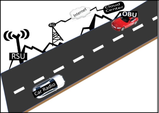
The proposed system consists of 3 major units. The roadside unit (RSU), the onboard unit (OBU) and remote-control centre (CC).
Figure 1 shows the interaction between these system components. Its shows a typical highway setup, with high-speed cars, hills, vegetation and forest. Existing 4G infrastructure along road axes provide internet connectivity for the RSU and remote cloud centre. Vehicles are equipped with radio receivers or a specialized OBU. The following subsections provide details of each of the units of the overall system.
Figure 1. Overall System Architecture.
2.1. Roadside Unit (RSU)
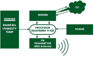
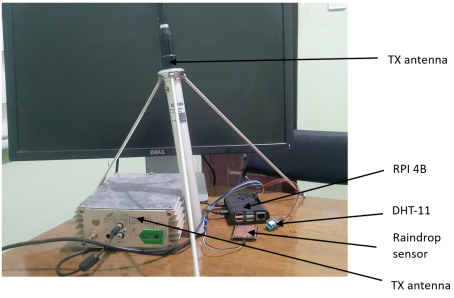
The experimental setup involves assembling the building blocks of the system. The various components of the RSU setup are shown in
Figure 2 & Figure 3 and include:
1) The DHT 11, a temperature and humidity sensor.
2) A ROBODO 130008 rain sensor to detect rain.
3) Internet connectivity via a wireless router.
4) A 3.5mm audio jack which connects to the transmitter.
5) A locally designed 5W transmitter, connected to an antenna via coax cable. The test frequency is set to FM 100.8MHz.
6) 50 ohms dipole antenna.
The RSU consist of a raspberry Pi 4 Model B, equipped with 4GB of RAM, with internet connectivity to the control centre, via modem. Raspberry Pi OS (Debian) runs on a 64GB SD card on which python and flask are installed. Python is robust with numerous libraries to support the dynamic radio broadcasting, through a 3.5mm audio jack to a transmitter. The roadside unit connects to a rainfall, temperature and humidity sensors, to collect real time true data of the RSU environment.
Figure 2. Block diagram of RSU.
Figure 3. Prototype of RSU.
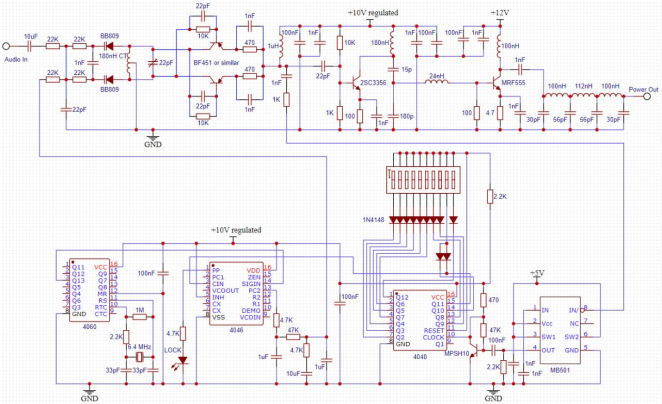
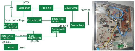
The transmitter is a phase locked loop (PLL) in which some of the signal from the voltage-controlled oscillator (VCO) supplies a pre-scaler, protected by a 1k resistor (
Figure 4). The transmitter is similar that in
with modifications to suit road side unit deployment. The voltage-controlled oscillator (VCO) is the first stage of the design. It’s essentially a Hartley oscillator. The driver stage consists of a 2N44 (maximum 1W, currently operating at 330mW). The RF section is made of 3 stages; the first stage is a Hartley oscillator, followed by a preamplifier stage using a BFR91, then a third stage comprising a class C amplifier.
Figure 4. Schematic of the local transmitter.
Signal is tapped from oscillator and is divided by the Philip pre-scalar (SAB6456) and is configured to divide by 64, and supplies its output to a CMOS divider (CD4040) which function as a countable divider. (divide by n counter). For example, for a VCO operating at 100MHz, the output will be set to 1.5625MHz Between the pre-scaler and CD4040, a logic level buffer is introduced to raise the logic level of the pre-scaler at the output of the SAB6456 (from about 1.2V peak to peak) to the full range supported by the CMOS chip). The CD4040 can divide from 0 – 2047. This output is fed into a phase comparator (CD4046). The other input is a reference counter (CD4060 – 14 stage binary counters with inbuilt amplifier and in this setup, 213 division ratio has been selected) which is used with a 6.4MHz crystal. The reference frequency is therefore (6.4MHz/8192) 0.00078125Hz.
In order for the loop the lock, it is required to divide the 1.5625MHz from the pre-scaler down to 781.25 (division ratio of exactly 2000). However, for the full range of the FM band, a counter that can support the full length 87.5MHz (divide by 1750) to 108MHz (divide by 2160). The comparator compares the phase difference between both signals and generates a particular voltage. Pin 1 (Pulse phases) goes low whenever the comparator outputs an error voltage. The pin can therefore act as a lock detector, by connecting an LED to it. Pin 13 (phase comparator) is the output of the phase detector which outputs a high if the divided down phase/frequency of the loop is lower than the reference and outputs a low otherwise. The output of this pin is fed into a varactor (BB809).
Figure 5. Block diagram of the local transmitter.
Figure 6. Class C amplifier circuit.
This amplifier circuit is a 5-watt RF (Radio Frequency) amplifier (
Figure 6), typically used to boost weak RF signals for transmission. The design is based around a BD135 NPN transistor (Q1) operating as a Class C amplifier, optimized for high-efficiency signal amplification. R1 (1kΩ) and C1 (10pF) form a simple input network, possibly providing initial biasing and DC blocking. C2 (40pF trimmer) and C3 (56pF), together with L1, form a tuned input matching network to resonate at the desired operating frequency, allowing efficient signal transfer. L1 is made from 0.9mm insulated copper wire with 7.5 turns, creating an inductive reactance to form a parallel resonant circuit with C2 and C3. The active device Q1 (BD135) is biased through R2 (220Ω) and R3 (1kΩ). These resistors provide a stable DC bias to the transistor's base. C4 (560pF) likely serves as a coupling or bypass capacitor to stabilize the RF gain. DR1 (10uH inductor) helps to isolate RF from the power line, suppressing RF feedback and noise. C5 (50pF trimmer) allows fine-tuning of the resonant frequency at the transistor output. C6 (33pF) works with L2 to form a tuned load, maximizing output power L2 (13 turns of 0.9mm wire) and C7 (50pF trimmer) form an output matching network that transfers power efficiently to the load (e.g., antenna). C8 (10nF), C9 (10µF), C10 (100nF), and C11 (47µF) serve as decoupling capacitors, filtering out noise from the power supply line. DR3 (1.5–2uH inductor) prevents RF from leaking into the power source. DR2 (a ferrite bead with a few turns of wire) further suppresses high-frequency interference. The circuit operates on a +12V to +15V DC power supply. Proper filtering and isolation components ensure the amplifier operates stably without RF feedback into the supply. The output is designed for a low-impedance RF load (a 50Ω antenna).
2.2. Onboard Unit (OBU)
The OBU is setup in the lab environment with the following components in
Figure 7 (block diagram and prototype).
An RTL-SDR V4 connected to the USB interface of the Raspberry PI 4 Model B. It receives FM from the transmitter, demodulates the audio content.
Speakers connected to the RPI for playback of demodulated FM signals from the RTL-SDR.
The onboard unit is typically an FM radio receiver – from inbuilt car radio system, a portable radio or the sophisticated OBU comprising of: a raspberry Pi 4 model with 4GB of RAM, coupled with a low-cost RTL-SDR dongle and a portable speaker for audio feedback. It is powered by a 5V power supply from a solar 20000Mah power bank, to easy mobility.
Figure 7. Block diagram of OBU.
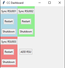
2.3. Control Centre (CC)
The control centre is remote server, which interacts with all RSU. The CC also manages all RSU and from it remote commands and configurations of the RSU is done. Communication between the RSU and CC is via SSH, to ensure secure communication. The CC dashboard is shown in
Figure 8.
Figure 8. Control Centre Dashboard.
The control centre is remote and can connect to each RSU via remote connection. From the dashboard, the RSU can be directly managed using secure protocols. Connecting to a Roadside Unit (RSU) from a remote-control centre using Secure Shell (SSH) offers secure and efficient communication. SSH utilizes asymmetric encryption algorithms like RSA (Rivest-Shamir-Adleman) for authentication and symmetric encryption such as AES (Advanced Encryption Standard) for encrypting data during transmission, ensuring confidentiality and integrity. This setup allows operators to remotely manage the RSU, execute commands, and troubleshoot issues without physical presence, enhancing operational efficiency. Additionally, SSH supports real-time monitoring of logs and performance metrics, facilitates multi-user access for collaborative efforts, and enables script automation for routine tasks, streamlining operations and reducing the need for field visits.
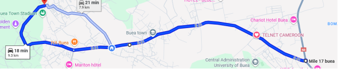
For testing purposes, the RSU is mounted on top a building (15m high) along the Molyko stretch of road (
Figure 9). Coordinates are pre-keyed into the python code (Mile 17, Buea – Buea town, Buea (10 km)). The TX is powered with AC ~ 220V and connected to the 50-ohm antenna. The OBU is placed in a car (Toyota) which equally has an in-built FM radio receiver. The OBU is powered by a 10,000mAh power bank via USB-C. (
Figure 7)
Figure 9. Road stretch for field test (source: Google maps).
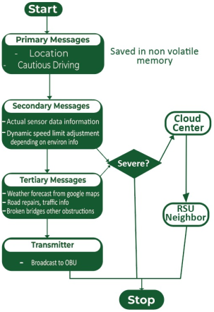
3. Algorithms and Flowcharts
Python code runs on the RSU RPI which has the main logic of the functioning of the high way radio. Visual studio code, GNU radio, GQRX and device drivers for the RTL-SDR are installed, after updating and upgrading the RPi OS repositories. The program setup includes setting the GPIO pins on the RPI to read the DHT-11 (PIN 11 and PIN 4) and the raindrop sensor (DO_PIN = 18).
RSU coordinates are preprogrammed in the RPI. This is used as the input location for forecasted weather in the vicinity. OpenWeatherMap (https://openweathermap.org/) provides the updated weather information for the RSU. The code uses an API key to get important information such as weather, visibility, sea-level, ground level and wind speed.
Humidity and temperature are measured in real-time by DHT-11 sensor. A function to print various messages based on the reported values of visibility is used to warn drivers on the severity of how sight might be impacted. A speed limit is proposed at this stage, which is a percentage of the default speed, preprogramed at the RSU (as earmarked by road signs). Equally, a driver warning message is generated from the values of the DHT-11 alone.
The coordinates of the stretch of road (6km) along the RSU is preprogrammed, so that with the use of an API key, the Google suit can calculate the live traffic situation and report normal versus delayed arrival times. This generates traffic delay information which is broadcasted to the driver. Hence, they can reroute. The same API key is used to comb around the RSU, and generate useful data about nearby places such as parking, gas stations, restaurants, banks, ATM etc and generate audio information. Vital information such as road works, deviations or accidents is equally fetched with the use of the API key. Every notification termed “severe” is forwarded to all the neighbours of the RSU.
A python function, play_audio() is used to play prerecorded audio saved on the SD card of the RSU. Such include welcome messages, various weather conditions and jingle breaks. Dynamic audio is generated by google text to speech function (gTTS).
Figure 10, summarizes the functionality of the RSU.
Figure 10. Flow chart of RSU functionality.
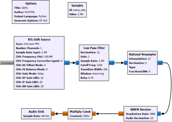
GNU radio software enables the RPI to process demodulated signals from the RTL-SDR and play the audio via the speaker. Python is used to achieve the logic at the RSU which is as follows.
1) RTL-SDR receives FM signals and passes it to the RPI.
2) RPI plays the audio from transmitter FM (100.8).
The complete block diagram of the signal processing that takes place at the onboard unit is shown in
Figure 10. It can be seen that RTL receives the transmitted signal from the RSU and passes it via several blocks, to eventual output demodulated audio.
Figure 11. GNU Block diagram for SDR.
The Options block specifies the title while Variables sets the sample_rate for the system. The first functional block is the RTL-SDR Source with several parameters (sample rate, centre frequency, gains). This block outputs to a Low Pass Filter with decimates the signal and outputs to a Relational Resampler. Next is the WBFM (wide band FM) Receive block which modulates the signal using QFSK and forwards the analogue data to a Multiply Constant block. The Audio Sink is the last compound that converts the analogue signal to audio.
4. Results and Discussion
Time complexity analysis: The RSU python code performs tasks such as reading sensor data, making API calls to OpenWeatherMap and Google Suite, processing received data, dynamically generating speed limits, generating audio using Google Text to Speech (gTTS), playing audio and forwarding severe notifications to neighbouring RSUs. Digital sensors provide a fast and reliable way of reading data (either high or low). API calls and network communications take up less than 3 seconds because the processing time on the RSU for parsing JSON responses is generally efficient. Generating the audio via gTTS also involves function calls. Data fetches on the internet and notification generation take up about 4s. To overcome this delay of about 7 to 8 seconds in total, the code runs at boot time on the raspberry pi. Its 4 core CPU provides enough power for processing and quick startup. CPU usage between 2 -5% is observed while the RSU is functioning properly. Pre-recorded audio (intro, welcome and basic driving practices reminder) plays first, and takes 10s. The code is carefully designed to keep running while audio plays. In this way, the audio plays seamlessly without any waiting time, as the entire code would have executed. The OBU python code (GNU radio) equally runs at startup and broadcasts audio from TX as soon as it powers on.
Space Complexity analysis: The RSU primarily stores sensor data (minimal), temporary API responses (small JSON objects), prerecorded or dynamically generated audio files. These don’t grow much in size there by requiring little storage and runtime memory constraints. The python code is designed to delete generate audio, every 1 hour. However, the RSU is equipped with 4GB of RAM and 64GB SD Card. RAM usage during normal execution fluctuates between 296 – 321MB.
Analysis of local hardware: The simulation results highlight the desirable performance of the locally designed FM transmitter intended for highway radio broadcasting at 100.8 MHz. The RF gain chain, comprising the BF451 (15 dB), 2SC3356 (12 dB), and MRF555 (16 dB), delivers a total gain of 43 dB, ensuring strong and clear signal amplification essential for reliable highway coverage. Power analysis confirms a stable output, with both the average and peak output power maintained at 5 W, supporting consistent signal reach along the highway. The transmitter operates with regulated supply voltages of +12V, +10V, and +5V, which enhances circuit stability and reliability. Furthermore, the crystal oscillator offers a stability of ±50 ppm, while the VCO achieves a phase noise of -90 dBc/Hz, both of which contribute to excellent frequency stability and low noise - critical for clear audio transmission in highway environments. These outcomes demonstrate that the locally developed FM transmitter is well-suited for highway radio systems, delivering dependable performance, robust coverage, and high-quality broadcast audio at 100.8 MHz.
From the experimental setup of the proposed system, three key performance indicators are used to assess the effectiveness of the broadcast system. The signal to noise ratio (SNR), modulation error rate (MER) and the power spectrum of the received audio signal was analysed in GNU radio on raspberry pi OS.
SNR
The signal to noise ratio is measured to evaluate the quality of the transmitted signal relative to background noise. SNR is a key metric for assessing the clarity and reliability of the received audio signal. Typically, SNR is calculated as follows;
(1)
Where
Psignal is the power received,
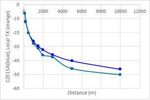
Pnoise is the noise floor power. A control transmitter, the CZE15A 15W transmitter is used to compare with the locally designed transmitter. The experimental setup used GNU radio open-source software to capture the SNR values at various distances, as shown in
Figure 11.
Figure 12. Comparison of received signal from CZE15A and Local transmitter.
The results demonstrate a clear inverse relationship between the distance and the SNR. At shorter distances, the SNR is high, but as the distance increases, the SNR drops due to environmental factors and signal attenuation. At 5000m, the SNR drops to -40.36dB which is still high enough, and in the range of acceptable audio quality for a highway radio service. This trend aligns with theoretical expectations (inverse square law). The higher values at shorter rangers affirms the effectiveness of the transmitter whereas at longer distance, optimal RSU placement maximises coverage and minimizes noise. The plot for the local transmitter (orange) shows similar trend as the ready-made CZE15A (blue), confirming the design is appropriate for its intended purpose.
Modulation Error Rate (MER)
Figure 13. Constellation diagram of TX signal.
Figure 14. Constellation diagram of demodulated signal.
Modulation Error Rate (MER) is a measure of the signal quality in digital modulation systems and provides an insight into the integrity of the transmitted signal. Constellation diagrams are critical visual tools in digital modulation systems used to assess MER and overall signal quality. The QT GUI Constellation Block in GNU radio is used to visualize signal quality of the received and modulated signals.
Figure 12 represents the received signal before demodulation and shows thick or spreading data points, indicating potential issues like low signal-to-noise ratio, interference or phase noise. In contrast,
Figure 13 illustrates the signal after demodulation and reveals tightly clustered points with a large radius. This tight clustering signifies a high SNR and consequently superior audio quality at the receiver, confirming the proper and effective operation of the transmitter-receiver pair.
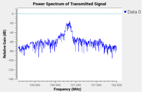
Power Spectrum
The power spectrum measures the power levels (dB) of a sample audio generated by the roadside unit before transmission against frequency in a given range (centre frequency 100.8).
Figure 14 depicts the power spectrum of the original audio before modulation (received signal) while
Figure 15 denotes the power spectrum of the received audio after modulation at the onboard unit. It can be seen that the variation is minimal.
Figure 15. Power spectrum of original audio signal.
Figure 16. Power spectrum of received audio signal.
It can be observed that the received signal (pre-modulation) is relatively flat, meaning the gain is small (-90dB to -25dB). But after modulation, the gain is improved. It is a good indication that the modulation was efficient and the audio quality at the speaker output is clear.
5. Conclusion
This paper set out to design a highway system for road survey and safety for a developing country. It proposed an FM based (intelligent transportation system on highways) with IoT functionality. The system made use of a locally designed 5W transmitter, which showed great efficiency as observed in the various performance indicators: SNR, MER and power spectrum. A highway radio service is achieved, which informs the driver about weather conditions, safe driving practices, real time traffic information, nearby places as well as dynamic speed limit suggestions. The system is cost effective but comprehensive with secure remote access to the components by using secure shell (SSH). Its audio-only broadcast nature further makes it reliable and free of distracting drivers along the highway.
In the context of vehicle to anything (VTX) communications, several factors can limit the efficiency of the overall system. Radio frequency from other wireless and congestion in the communication spectrum can degrade the signal quality and impact the reliability of the communication. The system does not accurately outline security mechanisms to protect transmitted data from TX to RX, which can lead to data breaches and unauthorized access. Finally, the RSU depends on internet connectivity for advanced functionalities such as weather forecast, traffic situation and nearby places. With the turbulent nature of Internet in developing countries, the system might loss some functionality.
The proposed system addresses the current need for an FM broadcast-based highway radio system. However, some improvements could be made to the system in the near future. It is incapable of stationary vehicle detection which is equally a cause of road accidents. With advancements in technology, integration of AI models could potentially improve the system as well.
Abbreviations
RSU | Roadside Unit |
OBU | Onboard Unit |
FM | Frequency Modulation |
CC | Control Center |
TX | Transmitter |
RX | Receiver |
Acknowledgments
The authors recognized the efforts of Mr Nyenti Roland for his efforts to source electronic components for the transmitter unit. Also, the efforts of Nnala Lawrencia and Frank Ibrahim go unnoticed which led to the success of the work.
Author Contributions
Taku Angwa Otto Che: Conceptualization, Resources
Sitamze Bertrand: Supervision, Writing – original draft
Ndukum Pascaline: Data curation, Writing – review & editing
Tsafack Pierre: Supervision
Funding
This work is not supported by any external funding.
Conflicts of Interest
The authors declare no conflicts of interest.
References
| [1] |
M. Yongji, X. Jinliang, G. Chao, M. Minghao, E. Guangxun and G. Chenwei, "Review of Research on Road Traffic Operation Risk Prevention and Control," Int J Environ Res Public Health, vol. 19, no.
https://doi.org/10.3390/ijerph191912115
, p. 12115, 2022.
|
| [2] |
GRSF, "General Road Safety Facility," World Bank Group, 2021.. Available:
https://www.globalroadsafetyfacility.org/speed-management-hub
(Accessed 09 October 2024).
|
| [3] |
J. A. Jones, "Blog, Car Accidents," Minnesota’s Trusted Personal Injury Litigators, 22 April 2021. Available:
https://www.jeffjoneslawoffice.com/blog/2021/04/whats-the-safest-possible-way-to-travel/
(Accessed 05 September 2022).
|
| [4] |
J. Sobngwi-Tambekou, J. Bhatti, G. Kounga, L.-R. Salmi and E. Lagarde, "Road traffic crashes on the Yaoundé–Douala road section, Cameroon," Accident Analysis and Prevention, vol. 42, pp. 422-426, 2010.
https://doi.org/10.1016/j.aap.2009.09.003
|
| [5] |
Sabinet African Journals, SANRAL Intelligent transportation systems: SAICE-SAFCEC 2016 awards, 01 November 2016. Available:
https://journals.co.za/doi/10.10520/EJC200109
(Accessed 06 March 2023).
|
| [6] |
Federal Road Safety Corps, FRSC. Intelligent Transport systems. Available:
https://frsc.gov.ng/
(Accessed 6 March 2023).
|
| [7] |
H. LESSIQ, "LES SYSTÈMES DE TRANSPORTS INTELLIGENTS AU MAROC," Brusselles, 2017.
|
| [8] |
KeNHA, "Kenya National Highways Authority," 2019. Available:
https://kenha.co.ke/
(Accessed 06 March 2023).
|
| [9] |
Ghana Highway Authority, Intelligent Traffic Management. Available:
https://www.highways.gov.gh/
(Accessed 06 March 2023).
|
| [10] |
SDR-Admin, "About RTL-SDR," Realtek, October 2023. Available:
https://www.rtl-sdr.com/about-rtl-sdr/
(Accessed 09 October 2024).
|
| [11] |
SDR-Admin, "Setting up a Raspberry Pi for Ham Radio with RTL-SDR," Realtek, 11 September 2020. Available:
https://www.rtl-sdr.com/setting-up-a-raspberry-pi-for-ham-radio-with-rtl-sdr/
(Accessed 09 October 2024).
|
| [12] |
P. K. N. Kouonchie, V. Oduol and G. N. Nyakoe, "Roadside Units for Vehicle-to-infrastructure communication: An Overview," in Proceedings of the Sustainable Research and Innovation Conference, Kenya, 2022.
|
| [13] |
W.-H. Lee and C.-Y. Chiu, "Design and Implementation of a smart traffic signal control system for smart city applicaitons," Sensors, vol. 20, no. 508, pp. 1-18, 2020.
https://doi.org/10.3390/s20020508
|
| [14] |
A. Al-Dweik, R. Muresan, M. Mayhew and M. Lieberman, "IoT-Based Multifunctional Scable Real-Time Enhanced Road Side Unit for Intelligent Transportation System," in 2017 IEEE 30th Canadian Conference on Electrical and Computer Engineering (CCECE), Utah.
https://doi.org/10.1109/CCECE.2017.7946618
|
| [15] |
A. Al-Dweik, M. Mayhew, R. Muresan, S. Al and A. Shami, "Using Technology to Make Roads Safer: Adaptive Speed Limits for an Intelligent Transportation System," IEEE vehicular technology magazine, vol. 12, no. 1, pp. 39-47, 2017.
https://doi.org/10.1109/MVT.2016.2634462
|
| [16] |
W.-H. Lee and J.-Y. Li, "An Eco-Driving Advisory System for Continuous Signalized Intersections by Vehicular Ad Hoc Network," Journal of Advanced Transportation, vol. 2018, pp. 1-12, 2018.
https://doi.org/10.1155/2018/5060481
|
| [17] |
R. Rajasekar and P. Sivakumar, "Swarm Based Intelligent Transportation Systems Using Internet of Things in Vehicular Ad-Hoc Network," Journal of Computational and Theoretical Nanoscience, vol. 17, pp. 1-6, 2020.
https://doi.org/10.1166/jctn.2020.9445
|
| [18] |
F. Hutu and R. G. Bozomitu, "Driver’s warning notifications by using FM RDS technology," in International Symposium on Signals, Circuits and Systems, Iasi, Romania, 2021.
https://doi.org/10.1109/ISSCS52333.2021.9497384
|
| [19] |
R. G. Bozomitu, F. Hutu and N. D. P. Ferreira, "Drivers’ Warning Application Through Image Notifications on the FM Radio Broadcasting Infrastructure," IEEE Access, 2017.:
https://doi.org/10.1109/ACCESS.2023.3241611
|
| [20] |
R. G. Bozomitu and F. D. Hutu, "Drivers’ Warning Application Through Personalized DSSS-CDMA Data Transmission by Using the FM Radio Broadcasting Infrastructure," IEEE Access, 2017.
https://doi.org/10.1109/ACCESS.2021.3050669.
|
| [21] |
Wireless Waffle, How not to Design Trasnmitters and Recievers ( Part 13: 1 Watt PLL transmitter)
http://wirelesswaffle.com/index.php?entry=entry211025-124629
. Available: (Accessed 12 December 2024).
|
Cite This Article
-
APA Style
Otto, T., Bertrand, S., Pascaline, N., Pierre, T. (2025). An FM Broadcast IoT System for Enhancing Highway Safety. International Journal of Sensors and Sensor Networks, 13(2), 33-45. https://doi.org/10.11648/j.ijssn.20251302.12
 Copy
|
Copy
|
 Download
ACS Style
Otto, T.; Bertrand, S.; Pascaline, N.; Pierre, T. An FM Broadcast IoT System for Enhancing Highway Safety. Int. J. Sens. Sens. Netw. 2025, 13(2), 33-45. doi: 10.11648/j.ijssn.20251302.12
Copy
|
Download
AMA Style
Otto T, Bertrand S, Pascaline N, Pierre T. An FM Broadcast IoT System for Enhancing Highway Safety. Int J Sens Sens Netw. 2025;13(2):33-45. doi: 10.11648/j.ijssn.20251302.12
Copy
|
Download
-
@article{10.11648/j.ijssn.20251302.12,
  author = {Taku Otto and Sitamtze Bertrand and Ndukum Pascaline and Tsafack Pierre},
  title = {An FM Broadcast IoT System for Enhancing Highway Safety
},
  journal = {International Journal of Sensors and Sensor Networks},
  volume = {13},
  number = {2},
  pages = {33-45},
  doi = {10.11648/j.ijssn.20251302.12},
  url = {https://doi.org/10.11648/j.ijssn.20251302.12},
  eprint = {https://article.sciencepublishinggroup.com/pdf/10.11648.j.ijssn.20251302.12},
  abstract = {Land travel on highways in developing countries, such as Cameroon, faces significant safety challenges due to factors like natural disasters, poor road networks, low-quality vehicles, error-prone drivers, and negligent pedestrians, with government investments showing only minor improvements in reducing road accidents. This paper proposes an Internet of Things (IoT) based FM broadcast system to enhance highway safety by providing real-time and timely guides to drivers. The proposed system comprises three main units: a Roadside Unit (RSU), an Onboard Unit (OBU), and a Control Centre (CC). The RSU is an IoT-based smart unit built around a Raspberry Pi 4 Model B, equipped with environmental sensors (DHT11 for temperature/humidity, ROBODO 130008 for rain) and internet connectivity. It integrates a locally designed 5W Phase Locked Loop (PLL) FM transmitter, set to a test frequency of 100.8 MHz, with a broadcast radius of 10 km. Python code on the RSU utilizes APIs like OpenWeatherMap and Google Suite to gather real-time weather forecasts, environmental data, traffic conditions (estimated arrival times, delays), and information on nearby places (parking, gas stations, lodging). It also dynamically suggests speed limits based on real-time weather and generates audio warnings for adverse conditions and road events. The system primarily uses an audio-only broadcast to minimize driver distraction. The OBU functions as a specialized receiver, consisting of a Raspberry Pi 4 Model B with an RTL-SDR dongle that demodulates and outputs FM audio to speakers, with GNU Radio software processing the signals. A remote-Control Centre manages and configures RSUs securely via SSH, enhancing operational efficiency. Experimental results confirm the system's effectiveness. The locally designed FM transmitter demonstrated robust performance with a total RF gain of 43 dB and stable 5W output power, along with excellent frequency stability (±50 ppm crystal oscillator, -90 dBc/Hz VCO phase noise). Performance indicators like Signal-to-Noise Ratio (SNR), Modulation Error Rate (MER), and power spectrum were analysed. SNR showed an inverse relationship with distance, dropping to -40.36 dB at 5000m, which is acceptable for highway radio quality, and tracked closely with a commercial transmitter. MER analysis indicated proper functioning of the transmitter-receiver pair, as demodulated signals exhibited tightly clustered constellation points, implying high SNR and better audio quality. Furthermore, the power spectrum showed minimal variation between original and received audio signals, with an improved gain post-modulation, ensuring clear audio output. This comprehensive system provides a robust and cost-effective solution for real-time highway advisories in developing countries.
},
 year = {2025}
}
Copy
|
Download
-
TY  - JOUR
T1  - An FM Broadcast IoT System for Enhancing Highway Safety

AU  - Taku Otto
AU  - Sitamtze Bertrand
AU  - Ndukum Pascaline
AU  - Tsafack Pierre
Y1  - 2025/10/14
PY  - 2025
N1  - https://doi.org/10.11648/j.ijssn.20251302.12
DO  - 10.11648/j.ijssn.20251302.12
T2  - International Journal of Sensors and Sensor Networks
JF  - International Journal of Sensors and Sensor Networks
JO  - International Journal of Sensors and Sensor Networks
SP  - 33
EP  - 45
PB  - Science Publishing Group
SN  - 2329-1788
UR  - https://doi.org/10.11648/j.ijssn.20251302.12
AB  - Land travel on highways in developing countries, such as Cameroon, faces significant safety challenges due to factors like natural disasters, poor road networks, low-quality vehicles, error-prone drivers, and negligent pedestrians, with government investments showing only minor improvements in reducing road accidents. This paper proposes an Internet of Things (IoT) based FM broadcast system to enhance highway safety by providing real-time and timely guides to drivers. The proposed system comprises three main units: a Roadside Unit (RSU), an Onboard Unit (OBU), and a Control Centre (CC). The RSU is an IoT-based smart unit built around a Raspberry Pi 4 Model B, equipped with environmental sensors (DHT11 for temperature/humidity, ROBODO 130008 for rain) and internet connectivity. It integrates a locally designed 5W Phase Locked Loop (PLL) FM transmitter, set to a test frequency of 100.8 MHz, with a broadcast radius of 10 km. Python code on the RSU utilizes APIs like OpenWeatherMap and Google Suite to gather real-time weather forecasts, environmental data, traffic conditions (estimated arrival times, delays), and information on nearby places (parking, gas stations, lodging). It also dynamically suggests speed limits based on real-time weather and generates audio warnings for adverse conditions and road events. The system primarily uses an audio-only broadcast to minimize driver distraction. The OBU functions as a specialized receiver, consisting of a Raspberry Pi 4 Model B with an RTL-SDR dongle that demodulates and outputs FM audio to speakers, with GNU Radio software processing the signals. A remote-Control Centre manages and configures RSUs securely via SSH, enhancing operational efficiency. Experimental results confirm the system's effectiveness. The locally designed FM transmitter demonstrated robust performance with a total RF gain of 43 dB and stable 5W output power, along with excellent frequency stability (±50 ppm crystal oscillator, -90 dBc/Hz VCO phase noise). Performance indicators like Signal-to-Noise Ratio (SNR), Modulation Error Rate (MER), and power spectrum were analysed. SNR showed an inverse relationship with distance, dropping to -40.36 dB at 5000m, which is acceptable for highway radio quality, and tracked closely with a commercial transmitter. MER analysis indicated proper functioning of the transmitter-receiver pair, as demodulated signals exhibited tightly clustered constellation points, implying high SNR and better audio quality. Furthermore, the power spectrum showed minimal variation between original and received audio signals, with an improved gain post-modulation, ensuring clear audio output. This comprehensive system provides a robust and cost-effective solution for real-time highway advisories in developing countries.

VL  - 13
IS  - 2
ER  -
Copy
|
Download