Research Article | | Peer-Reviewed

The Impact of Irrigation on Soil Physico-chemical Properties in Toke Kutaye District, West Shoa, Oromia Regional State, Ethiopia

Received: 27 August 2026     Accepted: 5 September 2026     Published: 11 November 2026
Views:       Downloads:
Abstract

Sustainable agricultural production and productivity depend on proper soil management and understanding how soils respond to agricultural practices over time. The objective of this study was to investigate the impact of small-scale irrigation on selected soil physico-chemical properties in comparison with cultivated and grazing land use systems in Toke Kutaye District. Three small scale irrigation schemes were selected from different directions of the district. A total of 60 composite soil samples were collected from irrigated, cultivated and grazing land use systems at two soil depths (0-15 and 15-30 cm) and analysed at the Debre Zeit National Soil Laboratory. The laboratory results were statistically analysed using SAS 9.4 software. The results indicated that soil pH (H2O), electrical conductivity (EC), soil organic carbon (SOC), available nitrogen (N), exchangeable potassium (K) and sodium (Na) showed no statistically significant differences among the land use systems across all irrigation schemes. However, variations were observed among land use systems, indicating the need for further investigation over longer cropping periods. In contrast, available phosphorus (P) and soil texture showed statistically significant differences among the land use systems and soil depths. However, small scale irrigation has not yet caused significant changes in most of the soil properties considered but continuous irrigation may influence soil quality over the longer cultivation periods. Therefore, long term monitoring over several cropping seasons is recommended to assess cumulative changes in soil properties, while alternative water sources and improved irrigation water management should be promoted to address irrigation water shortages and sustain crop production.

Published in American Journal of Ecology (Volume 1, Issue 1)
DOI 10.11648/j.ajoe.20260101.15
Page(s) 40-51
Creative Commons

This is an Open Access article, distributed under the terms of the Creative Commons Attribution 4.0 International License (http://creativecommons.org/licenses/by/4.0/), which permits unrestricted use, distribution and reproduction in any medium or format, provided the original work is properly cited.

Copyright

Copyright © The Author(s), 2026. Published by Science Publishing Group

Keywords

Crop Yield, Small Scale Irrigation, Soil Properties, Land Use Systems

1. Introduction
Ethiopia is an agrarian country where around 95% of the country’s agricultural output is produced by smallholder farmers in which accounts for 41.4% of Ethiopia’s GDP and 80% of total employment, is the country’s economic backbone . Small-scale rainfed agriculture makes up the majority of Ethiopia’s agricultural sector. However, Ethiopia's rain-fed agriculture is increasingly threatened by recurrent droughts, erratic rainfall, climate variability and highly inflation cost of input production packages . These agricultural production and productivity constraints making irrigation development a national priority for sustainable agricultural production. Consequently, different irrigation schemes (small scale, medium and large) have expanded rapidly across the country, particularly in the Awash Rift Valley, Abay, Omo Gibe, Wabi Shebelle and Tekeze River basins . Based on the current population growth and food demand of the country, Ethiopia, the use of small scale irrigation has a great importance to produce more during rainfall shortage periods. It can contribute to overall livelihood improvement of the rural population through increased income, food security, social needs fulfilment and poverty reduction . As a result, irrigated agriculture currently is a priority in the agricultural transformation and food security strategy of the Ethiopia government .
However, the sustainability of irrigation to enhances crop production and stabilizes yields, largely depends on the use of irrigation water quality. The suitability of irrigation water is commonly evaluated using parameters such as electrical conductivity (EC), sodium adsorption ratio (SAR), residual sodium carbonate (RSC), soluble sodium percentage (SSP), pH, total dissolved solids (TDS), and concentrations of major cations and anions. These indicators determine the potential of irrigation water to induce soil salinity, sodicity, infiltration problems, nutrient imbalance and toxicity . In Ethiopia, irrigation water quality varies considerably depending on water source, geology, climatic conditions, and land management practices. Surface water originating from rivers is generally suitable for irrigation in many regions, whereas groundwater and some lake waters often contain elevated concentrations of salts and sodium . Long term use of these water sources has contributed to increased soil salinity, sodicity, and deterioration of important soil quality indicators. Among soil physicochemical properties, texture, bulk density, porosity, infiltration rate, hydraulic conductivity, aggregate stability, soil pH, electrical conductivity, organic carbon, cation exchange capacity (CEC), exchangeable sodium percentage, available nutrients, and soil organic matter are particularly sensitive to irrigation water quality . Irrigation water quality is one of the most important determinants of sustainable soil productivity because it directly influences soil physical and chemical characteristics. Irrigation water containing excessive concentrations of soluble salts, sodium, bicarbonates and other dissolved ions gradually alters soil properties through salinization and sodification processes. These changes increase soil electrical conductivity (EC), exchangeable sodium percentage (ESP), sodium adsorption ratio (SAR), soil pH and bulk density while reducing aggregate stability, infiltration rate, hydraulic conductivity, porosity, nutrient availability and microbial activity .
The problem is becoming increasingly serious in Ethiopia because many irrigation schemes are located in arid and semi-arid regions where high evaporation rates, inadequate drainage systems, and continuous irrigation favour the accumulation of salts in the root zone . In several irrigation command areas, farmers increasingly rely on surface water, groundwater, lake water and blended water sources without repetitive assessment of their chemical suitability for irrigation . For the production enhancement purpose, the continuous application of marginal-quality water accelerates soil degradation, resulting in declining soil fertility, reduced crop yields and increased costs for land rehabilitation. These conditions threaten the long-term sustainability of irrigated agriculture, particularly under the increasing pressures of climate change and growing competition for freshwater resources .
In Ethiopia, under the current irrigation water management strategies and soil conservation interventions practices, monitoring of irrigation water quality and soil physicochemical properties is not consistently practiced to sustain irrigation schemes and crop productivities. Therefore, this study was aimed to evaluate the impact of irrigation water quality on soil physicochemical properties in selected irrigation schemes in Toke Kutaye district, of West Shewa Zone, Oromia Regional State, Ethiopia to improve soil health, enhance irrigation sustainability and maintain long term agricultural productivity.
2. Materials and Methods
2.1. Description of the Study Area
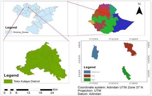
The study was undertaken in West Shoa zone, Toke-kutaye District which is located in the West part of the zone at a distance of 12 km from Ambo, the capital town of the zone and 132 km, from capital city of the country, Addis Ababa. Toke Kutaye district is one of the potential irrigated area in the zone and bordered on the East by Ambo and wanchi, on the South by Dirre Incinni and Amayya, on the West by the Chaliya and Jibat, and on the North by Midaqegn Districts. The administrative Center of the district is Guder with 4 urban kebeles and 31 rural kebeles. The map of the study area was shown in (Figure 1).
Figure 1. Map of the study area (Toke Kutaye District).
There are 16 modern irrigation schemes and 56 traditional irrigation schemes in the district. The modern irrigation schemes have structured management system throughout the irrigation period to maintain the sustainability of the irrigation system governed by the district irrigation office.
In terms of agroecological condition of the district, the district categorized in to Dega (27%), Woina Dega (55%), and Kola (18%). The altitude of the district ranges from 1600 to 3192 m.a.s.l. The average annual temperatures range between 22-29oc with an annual rainfall of 100 to 1100 mm and the major crops grown in the district are Teff, maize, wheat and barley and commonly irrigated crops like tomato, potato, onion etc. Moreover, the district have different known river flown in the district such as Guder, Colle, indris and kolba which potentially used for irrigation at different scale of irrigation.
2.2. Sampling Methods, Sample Preparation and Analysis
Three modern irrigation schemes were purposively selected based on age of irrigated land (> 5 years) in the district. The selected schemes were Maruf Irrigation schemes in the western part of the district, Chancho Aruse scheme in the centeral part of the district and Chole irrigation schemes in Eastern part of the district. From each scheme three land use system were selected (irrigated land, cultivated non irrigated land and grazing land) for comparison of the impact of irrigation on physico-chemical properties of the soil. For each irrigation schemes 20 composite soil samples at two depths (0 -15 and 15-30cm) were taken. For all schemes the samples were taken at two locations (upper and lower of irrigation schemes with that of the other land use systems) by using auger except for bulk density which was taken by core sampler. The soil samples were taken from all the targeted points and samples were labeled according to the land use systems with respective depths. After the composite samples were prepared following the soil laboratory standards, the samples were air dried in the laboratory, grinded and sieved with a 2mm size sieve then each sample was weighted to 300gm for laboratory analysis of all considered parameters.
The prepared and labelled soil samples were sent to Debre Zeith National soil laboratory for analaysis of the Selected soil physico-chemical properties. The soil physico-chemical properties considered were soil texture, soil pH, electrical conductivity of the saturated extract (ECe), Organic Carbon, Exchangeable bases K and Na. The result of soil physico-chemical properties laboratory analysis of each sample was taken, and analysed by using SAS software 9.4 versions.
3. Results and Discussions
3.1. Soil Textural Analysis of the Study Area
There are many soil physical properties to be considered in irrigation aspects but due to lack of instruments and laboratory facilities all of them were not considered. The soil samples taken from Chanco irrigation schemes and adjacent land use systems in both location (upper and lower) at two depths (0 -15 and 15 -30cm) was analysed following laboratory standards. The laboratory result showed that the textural class of the soil in the irrigation schemes ranges from Sandy Clay Loam to clay. The soil textural analysis this irrigation scheme and adjacent land use systems considered across the depth were presented in the (Table 1).
Table 1. Analysis of soil texture at Chancho irrigation schemes for different land use system.

Land Use Systems

Depth

Chancho

Soil Textural Class

Clay

Silt

sand

Upper Irrigated Land

1

37.20b

32.12a

30.67a

Clay Loam

2

41.20a

32.80a

26.00b

Clay

Lower Irrigated Land

1

38.80a

21.60b

39.60a

Clay Loam

2

38.80a

29.60a

31.60b

Clay Loam

Upper Cultivated Land

1

28.80b

23.60b

47.60a

Sandy Clay Loam

2

42.80a

25.60a

31.60b

Clay

Lower Cultivated Land

1

43.60b

31.33a

25.07a

Clay

2

48.27a

27.33b

24.40a

Clay

Upper grazing land

1

22.80b

39.60a

37.60a

Clay

2

48.80a

27.60b

23.60b

Loam

Lower Grazing Land

1

32.00b

33.20a

34.80b

Clay

2

44.80a

17.60b

37.60a

Clay Loam

CV 22.77 LSD (0.05%) 1.01
LSD (0.05%)
As the soil sample analysis result indicated, the soil texture in all land use system at Chancho irrigation schemes were classified as clay properties. The statistical analysis indicated the significance variations among the land use systems as well as across the depth. Since the soil of the area has a clay property, it requires a serious irrigation management aspect to overcome its adverse effect on the soil and crop productivity.
In the similar ways, the soil samples taken from Chole irrigation schemes and adjacent land use systems in both location (upper and lower) at two depths (0-15 and 15-30cm) was analysed following laboratory standards. The laboratory result showed that the textural class of the soil in the irrigation schemes showed clay loam properties. The soil textural analysis this irrigation scheme and adjacent land use systems considered across the depth were presented in the (Table 2).
Table 2. Analysis of soil texture at Chole irrigation schemes for different land use system.

Land Use Systems

Depth

Chole

Soil Textural Class

Clay

Silt

sand

Upper Irrigated Land

1

33.87b

35.20a

30.93a

Clay Loam

2

41.47a

29.87b

28.53b

Clay

Lower Irrigated Land

1

23.20b

35.20a

41.60a

Loam

2

48.00a

33.20b

18.80b

Clay

Upper Cultivated Land

1

33.20a

35.20a

31.60a

Clay Loam

2

25.20b

35.20a

39.60b

Loam

Lower Cultivated Land

1

35.07a

41.87b

23.07a

Clay Loam

2

32.40b

48.53a

19.08b

Silty Clay Loam

Upper grazing land

1

28.00b

37.20a

34.80a

Clay Loam

2

33.20a

33.20b

33.60b

Clay Loam

Lower Grazing Land

1

27.20b

33.20a

39.60a

Clay Loam

2

41.20a

31.20b

27.60b

Clay

CV 29.16 LSD (0.05%) 0.94
LSD (0.05%)
As a soil laboratory analysis indicated, there were statistically significance variations among the land use systems as well as across the soil depth in soil texture. Since the soil of the area has a clay loam property, it is more appropriate for irrigation but again irrigation management is should take critical consideration according to the crop types and growth stage to maintain the sustainability of the irrigation schemes.
The other irrigation scheme considered in the study was Maruf Irrigation scheme. Again, the soil samples taken from Maruf irrigation schemes and adjacent land use systems in both location (upper and lower) at two depths (0-15 and 15-30cm) was analysed following laboratory standards. The laboratory result showed that the textural class of the soil in the irrigation schemes showed loam properties. The soil textural analysis this irrigation scheme and adjacent land use systems considered across the depth were presented in the (Table 3).
Table 3. Analysis of soil texture at Maruf irrigation schemes for different land use system.

Land use systems

Depth

Maruf

Soil Textural Class

Clay

Silt

sand

Upper Irrigated Land

1

18.67a

41.60a

39.73a

Loam

2

27.47b

40.40b

32.13b

Clay Loam

Lower Irrigated Land

1

13.20b

35.20a

51.60a

Loam

2

20.80a

26.40b

52.80a

Sandy Clay Loam

Upper Cultivated Land

1

16.80b

30.40a

52.80b

Sandy Loam

2

18.80b

22.40b

58.80a

Sandy Loam

Lower Cultivated Land

1

30.13b

30.80a

39.07a

Clay Loam

2

36.13a

31.47a

32.40b

Clay Loam

Upper grazing land

1

18.80b

34.40a

46.80a

Loam

2

26.80a

34.40a

38.80b

Loam

Lower Grazing Land

1

16.80b

40.40a

42.80a

Loam

2

22.80a

36.40b

40.80b

Loam

CV 26.83 LSD (0.05%) 1.03
LSD (0.05%)
As the result revealed, statistically there were a significance variation among the land use systems as well as across the soil depth in soil texture classes. Since the soil of the area has a light soil property, it requires more appropriate irrigation scheduling based on the types of crop and crop growth stages.
3.2. Impact of Irrigation on Selected Soil Chemical Properties
Similar to the soil physical properties, also there are many soil chemical properties to be considered in irrigation but due to some instruments and laboratory analysis, all of thema were not considered in this study. However, the most critical parameters were considered as the follows.
3.2.1. Analysis of Soil pH in the Different Land Use Systems Across the Depth
The soil pH for all land use system at all location indicates slightly acidic. For all irrigation schemes (Chancho, Chole and Maruf), the soil pH was increased as the depth of soil increased for all land use systems except Maruf irrigation schemes which decreased as the depth of the soil increased at upper irrigation schemes. At both locations (upper and lower) for all schemes the pH value of irrigated land use systems was higher than that of cultivated and grazing land use systems. But for all land use system statistically no significance difference in the depth wise as well as across land use system for soil pH values. The pH values for all irrigation schemes in the upper and lower location at two depths of soil for different land use systems were presented in (Table 4).
Table 4. Analysis of soil pH across different land use system in the study area.

Location of Irrigation scheme

Soil depth

Land use systems

UPI

LWI

UPC

LWC

UPG

LWG

Chancho

1

6.39a

5.84a

5.83a

6.22a

6.01a

6.13a

2

6.41a

5.93a

5.95a

6.33a

6.23a

6.82a

CV = 2.66 LSD (0.05%) = 1.07

Chole

1

6.16a

6.16a

6.11a

6.64a

6.19a

5.56a

2

6.38a

6.17a

6.02a

6.72a

6.10a

6.48a

CV = 2.35 LSD (0.05%) = 1.14

Maruf

1

6.16a

6.28a

6.33a

5.56a

5.74a

5.77a

2

5.68a

6.17a

6.48a

5.90a

5.82a

5.68a

CV = 2.86 LSD (0.05%) = 0.94

Note: Depth 1 = 0-15cm, Depth 2 = 15-30cm UPIL = Upper irrigated land, LWIL = Lower irrigated land, UPCL = Upper irrigated land, LWCL = Lower irrigated land, UPGL = Upper grazing land, LWGL = Lower grazing land.
The result of the current study pH value ranges from 5.56 to 6.72 which indicate slightly acidic for all land use systems. Hence the pH value of soil from 6.5 to 8.4 has no adverse effect for most irrigated soil, the irrigation schemes selected for this study was under normal status in terms of soil pH. Generally, pH of the soil in irrigated land and grazing land were higher than that of cultivated land use systems. The result of the present study was similar with the study findings by which revealed as pH value of irrigated land use system was higher than adjacent to other land use systems. But the variation in soil pH across the land use systems were not uniform in all irrigation schemes selected in this study. Similarly, the study finding by showed that the pH of the soil in irrigated land was greater than the other land use but statistically no significance difference.
3.2.2. Analysis of Electrical Conductivity of Different Land Use Systems Across the Depth
Soil electrical conductivity (EC) obviously affects many soil physical and chemical properties which correlate soil properties that affect crop productivity, including soil texture, cation exchange capacity drainage conditions, organic matter level, salinity and subsoil characteristics. The EC indicates the presence or absence of salts but does not indicate which salts might be present. The result of the current soil physico-chemical property analysis was revealed that there was no statistically significance variation across the depth at all land use systems except at Chancho, upper irrigated, chole upper cultivated non irrigated and Maruf lower irrigated locations. In general, for most land use systems there were a statistically significance difference between irrigated and non-irrigated land use systems. This indicates that irrigation has an effect on soil electrical conductivity which needs some consideration for repeated irrigation in the future because as EC increases, more attention to water management is needed to prevent adverse effects of salinity development that affects soil and crop productivity. The result of EC analysis of the current study presented in (Table 5).
Table 5. Analysis of soil Electrical Conductivity of different land use system.

Location of Irrigation scheme

Soil depth

Land use systems (EC dS/m)

UPI

LWI

UPC

LWC

UPG

LWG

Chancho

1

5.92a

3.66a

3.59a

5.02a

2.55b

4.90a

2

4.40b

3.14a

3.40a

3.11b

3.95a

2.48b

CV = 2.29 LSD (0.05%) = 0.89

Chole

1

4.00a

3.58a

3.81a

4.60a

4.10a

3.47a

2

4.48a

3.84a

2.52b

4.23a

2.83b

3.45a

CV = 10.70 LSD (0.05%) = 0.94

Maruf

1

3.68a

3.74a

2.43a

4.60a

3.70a

2.96a

2

2.83a

2.73b

3.02a

3.94a

2.60a

2.62a

CV = 22.30 LSD (0.05%) = 1.11

Note: Depth 1 = 0-15cm, Depth 2 = 15-30cm UPIL = Upper irrigated land, LWIL = Lower irrigated land, UPCL = Upper irrigated land, LWCL = Lower irrigated land, UPGL = Upper grazing land, LWGL = Lower grazing land.
The crop sensitivity to EC was vary in which some crops affect to the extent of 2 dS/m (orange, beans, tomato etc.) and other can survive up to 16 dS/m (burley, sugar beet, cotton etc.). In the current study, the highest (5.92) and lowest (2.43) soil EC was obtained at irrigated upper Chancho and upper cultivated Maruf land use system respectively.
The study conducted by on Effects of Land Use, Soil Depth and Topography on Soil Physico-chemical Properties revealed that the soil electrical conductivity increased across the depth and more at lower part of the irrigation lands. Similarly, other study findings by revealed that the Electrical conductivity of soil varies with depth and its range of variation was less in upper soil profile probably due to slope of land surface, high permeability and high rainfall leaching out alkaline bases.
3.2.3. Analysis of Organic Carbon in the Different Land Use System Across the Depth
The result of the present study indicated that there was statistically no significance difference in soil organic carbon across the depth in all land use systems. The highest (1.83) and lowest (0.82) organic carbon was recorded at lower Chancho grazing land and upper Chole cultivated land use systems respectively. Generally, in all land use systems at all location of the soil sampling, soil organic carbon was slightly decreasing across the depth except at upper Chancho irrigated land use system. The result of the soil organic carbon analysed in all land use systems across the depth was presented in the (Table 6).
The value reported in our study was in the range of the recommended soil organic carbon for soil stability as well as the crop productivity. Similar to the current study, the finding of showed that the organic carbon in the irrigation land use slightly changed acroos the depth.
Table 6. Analysis of soil organic carbon in the different land use systems.

Location of Irrigation scheme

Soil depth

Land use systems (%)

UPI

LWI

UPC

LWC

UPG

LWG

Chancho

1

0.92a

1.35a

1.55a

1.14a

1.31a

1.45a

2

0.93a

1.12a

1.23a

0.96a

1.08a

0.82a

CV = 9.41 LSD (0.05%) = 0.88

Chole

1

1.02a

0.92a

1.83a

1.25a

1.21a

1.54a

2

0.92a

0.91a

1.37a

1.06a

1.19a

1.05a

CV = 11.31 LSD (0.05%) = 0.94

Maruf

1

1.28a

1.37a

1.74a

1.23a

0.90a

1.11a

2

1.01a

1.03a

1.11a

0.99a

1.01a

1.37a

CV = 4.37 LSD (0.05%) = 0.84

Note: Depth 1 = 0-15cm, Depth 2 = 15-30cm UPIL = Upper irrigated land, LWIL = Lower irrigated land, UPCL = Upper irrigated land, LWCL = Lower irrigated land, UPGL = Upper grazing land, LWGL = Lower grazing land.
Also, the current study result was similar with the study conducted by , revealed that, the soil organic carbon decreased across the depth in different land use systems.
3.2.4. Analysis of Total Available Nitrogen in the Different Land Use Systems
The result of this study revealed that, there was statistically no significance difference across the depth in all land use systems. But there was a variation in different land use systems. The highest (0.24) and lowest (0.09) total available N was recorded at Maruf lower irrigated land and chole upper grazing land use systems respectively. However, the obtained total available N was within the recommended ranges. The result of soil sampled at each land use systems on total available N across the depth was presented in (Table 7).
Table 7. Analysis of total available Nitrogen in different land use systems.

Location of Irrigation scheme

Soil depth

Land use systems (%)

UPI

LWI

UPC

LWC

UPG

LWG

Chancho

1

0.12a

0.15a

0.22a

0.12a

0.17a

0.13a

2

0.11a

0.11a

0.13a

0.14a

0.15a

0.14a

CV = 9.56 LSD (0.05%) = 0.87

Chole

1

0.13a

0.14a

0.14a

0.15a

0.13a

0.17a

2

0.13a

0.11a

0.22a

0.10a

0.09a

0.12a

CV = 17.73 LSD (0.05%) = 0.89

Maruf

1

0.16a

0.23a

0.19a

0.22a

0.16a

0.15a

2

0.17a

0.19a

0.24a

0.19a

0.15a

0.22a

CV = 6.91 LSD (0.05%) = 1.03

Note: Depth 1 = 0-15cm, Depth 2 = 15-30cm UPIL = Upper irrigated land, LWIL = Lower irrigated land, UPCL = Upper irrigated land, LWCL = Lower irrigated land, UPGL = Upper grazing land, LWGL = Lower grazing land.
Similar to the current study, the finding by , showed that the total available nitrogen showed variation across different land use system but statistically not significant. The other study conducted by , revealed that the effect of different land use system showed the available nitrogen statistically non-significant.
3.2.5. Analysis of Available Phosphorus in the Different Land Use Systems
The result of present study indicated that the available phosphorus in almost all land use system was decreasing across the depth. The highest (14.06) and lowest (4.19) available phosphorus was recorded at Maruf upper irrigated land and Chancho lower irrigated land respectively. There were statistically significance variations in available phosphorus under all land use system along the depth as well as across the land use systems. The available phosphorus was relatively higher in irrigated land as compared to the other land use system this may be due to the application of fertilizers with the source of phosphorus. The result of soil sample analysed on available phosphorus was presented in the (Table 8).
Table 8. Analysis of Available Phosphorus in the different land use systems across depth.

Location of Irrigation scheme

Soil depth

Land use systems

UPI

LWI

UPC

LWC

UPG

LWG

Chancho

1

10.64a

4.19b

5.51a

11.43a

9.46a

8.14a

2

6.63b

4.68a

4.56b

8.71b

6.08b

4.48b

CV = 7.48 LSD (0.05%) = 0.92

Chole

1

9.27a

8.99a

6.88a

9.56a

6.26b

5.82a

2

6.25b

4.50b

5.76b

5.39b

9.26a

5.04a

CV = 23.05 LSD (0.05%) = 0.86

Maruf

1

11.94b

7.24a

5.27b

10.57a

6.91a

5.11a

2

14.06a

4.57b

13.10a

6.54b

5.27b

5.44a

CV = 24.69 LSD (0.05%) = 0.95

Note: Depth 1 = 0-15cm, Depth 2 = 15-30cm UPIL = Upper irrigated land, LWIL = Lower irrigated land, UPCL = Upper irrigated land, LWCL = Lower irrigated land, UPGL = Upper grazing land, LWGL = Lower grazing land.
The result of the current study was similar with the study conducted by in which the result obtained that the available phosphorus recorded was higher in irrigated land than in adjacent land use systems. Similar to the current study, the study conducted by on Evaluation of Physicochemical Characteristics of Soils in the flood disaster affected areas indicated that there was a variation in total and available phosphorus in different land use systems considered and also a great variation in time with different studies in the area. The other study conducted by indicated that there was a variation in available phosphorus across different land use type in the study site which was similar to the current study on available phosphorus across different land use systems.
3.2.6. Analysis of Exchangeable Potassium in the Different Land Use System Across Depth
The result of current study revealed that there were statistically no significance differences across the depth as well as land use systems in exchangeable potassium. The highest (1.31) and lowest (0.35) exchangeable potassium was recorded at Maruf upper cultivated land and lower grazing land use systems respectively. The result of soil sample analysed for different land use systems considered on exchangeable potassium was presented on (Table 9).
Table 9. Analysis of Exchangeable potassium in the different land use system across the depth.

Location of Irrigation scheme

Soil depth

Land use systems (cmol/kg)

UPI

LWI

UPC

LWC

UPG

LWG

Chancho

1

0.87a

0.96a

0.85a

1.15a

0.85a

1.08a

2

1.08a

0.92a

0.84a

1.00a

0.91a

1.01a

CV = 7.48 LSD (0.05%) = 0.89

LSD (0.05%)

Chole

1

0.94a

0.77a

1.28a

1.06a

0.94a

0.96a

2

0.82a

0.64a

0.81a

1.09a

0.76a

1.25a

CV = 21.10 LSD (0.05%) = 0.97 LSD (0.05%)

Maruf

1

1.13a

1.01a

0.66a

0.56a

0.37a

0.35a

2

0.52a

0.87a

1.31a

0.55a

0.72a

0.84a

CV = 25.61 LSD (0.05%) = 1.02 LSD (0.05%)

Note: Depth 1 = 0-15cm, Depth 2 = 15-30cm UPIL = Upper irrigated land, LWIL = Lower irrigated land, UPCL = Upper irrigated land, LWCL = Lower irrigated land, UPGL = Upper grazing land, LWGL = Lower grazing land.
Similar to the current study, the study conducted by revealed that the potassium obtained in the cultivated land was lower than the other land use system. The other study conducted by indicated that the exchangeable potassium was higher in irrigated land than adjacent land use systems but in this study the variation was more in depth wise than the land use systems however the variation across the land use systems was not uniform.
3.2.7. Analysis of Exchangeable Sodium in the Different Land Use System Across the Depth
The amount of sodium content in the soil is very important as it affects the soil aggregate stability mostly in irrigated land in relation to the irrigation water quality. The current study revealed that there were statistically no significance differences in exchangeable Na across the depth in all land use systems. The highest (0.63cmol/kg) and lowest values (0.02cmol/kg) were recorded at Maruf lower cultivated and Chole lower irrigated land use systems respectively. The result of soil sample analysed on exchangeable Na across the depth in all land use systems were presented in (Table 10).
Table 10. Analysis of exchangeable Sodium in the different land use system.

Location of Irrigation scheme

Soil depth (cm)

Land use systems (cmol/kg)

UPI

LWI

UPC

LWC

UPG

LWG

Chancho

1

0.43a

0.13a

0.18a

0.49a

0.48a

0.31a

2

0.54a

0.22a

0.29a

0.63a

0.29a

0.59a

CV = 17.20 LSD (0.05%) = 1.02 LSD (0.05%)

Chole

1

0.37a

0.02a

0.11a

0.39a

0.61a

0.20a

2

0.34a

0.29a

0.12a

0.55a

0.02a

0.35a

CV = 17.47 LSD (0.05%) = 1.00 LSD (0.05%)

Maruf

1

0.20a

0.04a

0.11a

0.19a

0.11a

0.20a

2

0.29a

0.04a

0.15a

0.29a

0.09a

0.13a

CV = 6.64 LSD (0.05%) = 1.05 LSD (0.05%)

Note: Depth 1 = 0-15cm, Depth 2 = 15-30cm UPIL = Upper irrigated land, LWIL = Lower irrigated land, UPCL = Upper irrigated land, LWCL = Lower irrigated land, UPGL = Upper grazing land, LWGL = Lower grazing land.
The study conducted by indicated that there were variations on exchangeable sodium between different land use systems unlike to the current study. The study conducted by indicated that the exchangeable sodium for different land use types considered was within the recommended range which was similar to the current study but not statistically significant variation across different land use systems.
4. Conclusion and Recommendations
Agriculture is the backbone of the Ethiopian economy that directly or indirectly supports the livelihoods of more than 80% of the country's population. However, agricultural production and productivity have been constrained by many factors, like rainfall variability over the time, reduction of soil fertility status, low soil and water conservation practices, less capacity to climate change adaptation and mitigation, and low local community perceptions. To overcome many of these problems of agricultural production and productivity, the Government of Ethiopia has given considerable attention to the development and expansion of small-scale irrigation schemes throughout the country. However, long-term irrigation practices may also influence soil quality and fertility through changes in soil physical and chemical properties, which requires critical consideration of irrigation water management aspects. In line this consideration, this study was conducted in Toke Kutaye District to assess the impact of irrigation on selected soil physico-chemical properties under different land use systems. Based on the predetermined selection criteria, three small-scale irrigation schemes, namely Chancho, Chole and Maruf were selected from different directions of the district. Soil samples were collected following standard soil sampling procedures, prepared for laboratory analysis and submitted to the Debre Zeit National Soil Laboratory.
The results of the laboratory analysis indicated that irrigation had not yet caused statistically significant changes in most of the investigated soil physico-chemical properties across the different land-use systems in the three irrigation schemes. Although differences were observed in soil pH, electrical conductivity (EC), organic carbon (OC), available nitrogen (N), available potassium (K), and sodium (Na), these differences were not statistically significant. Statistically significant differences were observed mainly in available phosphorus and soil texture. In general, the soil properties observed in the study area were within ranges suitable for the production of most crops. This indicates that irrigation has not yet resulted in serious deterioration of soil quality in the selected irrigation schemes. But this not fully granted for the future maintaining soil and crop productivity, which requires continuous managements.
Even if the considered parameters are statistically not significant, the observed variation showed among land-use systems indicate the need for continuous monitoring and appropriate soil management. If irrigation is continuously practiced without proper water and soil management, gradual changes in soil properties may occur over time, potentially affecting soil productivity and crop production. Generally, from the current study it can be concluded that the current irrigation practices not critically affecting soil parameters considered but the variation indicates that there will be the requirement of continuous management of the irrigation water.
Based on the result of the current study, the following recommendation are forwarded
1) The most important soil physicochemical properties should be monitored periodically, particularly for these related to irrigation water and crucially influence the crop production and productivity. because, regular soil testing will enable early identification of potential soil degradation problems and facilitate site-specific soil fertility management.
2) Since this study undertaken in short period of time and a smaller number of irrigation schemes, future studies should include longer time of study and a greater number of irrigation schemes to come up with sustainable conclusions.
3) Furthermore, Agricultural extension services should provide farmers with practical training on irrigation scheduling, soil fertility management, water conservation, crop selection and sustainable land management practices.
Abbreviations

CEC

Cation Exchange Capacity

EC

Electrical Conductivity

ESP

Exchangeable Sodium Percentage

GDP

Growth Domestic Product

K

Available Potassium

N

Available Nitrogen

Na

Sodium

OC

Organic Carbon

RSC

Residual Sodium Carbonate

SAR

Sodium Adsorption Ratio

SSP

Soluble Sodium Percentage

Author Contributions
Belay Yadeta Negera: Conceptualization, Data curation, Formal Analysis, Investigation, Methodology, Project administration, Resources, Validation, Visualization, Writing – original draft, Writing – review & editing
Conflicts of Interest
The author declare no conflict of interest.
References
[1] Abdissa F, Tesema G. and Yirga C. (2017). Impact analysis of small scale irrigation schemes on household food security the Case of Sibu Sire District in Western Oromia, Ethiopia. Irrigation Drainage Syst Eng.,
[2] Ali Javadi, Behrouz Mostafazadeh-Fard, Mohammad Shayannejad, Mohammad Reza Mosaddeghi and Hamed Ebrahimian. (2019). Soil physical and chemical properties and drain water quality as affected by irrigation and leaching managements. Soil Science and Plant Nutrition, 65(4), 321-331,
[3] Asayehegn K. (2012). Irrigation versus rain-fed agriculture: driving for households’ income disparity, a study from central Tigray. Ethiopia J Agricu Sci Res., 2(1): 20-9.
[4] Azadi, A., Shakeri, S. and Azadi, H. (2025). Impact of different land uses on potassium forms and soil properties: the case of southwestern Iran. Environ Dev Sustain, 27, 25815-25840.
[5] B. W. Tukura, E. G. Ibrahim, E. U. Onche and M. A. G. Ibrahim. (2013). Preliminary Assessment of Physicochemical Properties of Borehole Water in the vicinity of Public Health Facilities in Nasarawa State, Nigeria. Journal of Applied Chemistry, 5(6)
[6] Cichota R., Kelliher F., Thomas S., Clemens G., Fraser P. and Carrick S. (2016). Effects of irrigation intensity on preferential solute transport in a stony soil. New Zealand Journal of Agricultural Research, 59(2): 1-15.
[7] Condron LM, Hopkins DW, Gregorich EG, Black A, Wakelin S. (2014). Long-term irrigation effects on soil organic matter under temperate grazed pasture. European Journal of Soil Science., 65(5): 741-750.
[8] Gebissa Yigezu. (2021). The challenges and prospects of Ethiopian agriculture. Cogent Food and Agriculture, 7(1): 1923619,
[9] Ghosh S, Mondal G, Chakraborty S, Banerjee S, Kumar S, Basu R and Bhattacharyya P. (2025). Geogenic perspectives on potassium dynamics and plant uptake insights from natural and submerged conditions across different soil types with machine learning predictions. Front Soil Sci., 5: 1539477.
[10] John J. Drewry, Sam Carrick, Veronica Penny, David J. Houlbrooke, Seth Laurenson and Nicole L. Mesman. (2020). Effects of irrigation on soil physical properties in predominantly pastoral farming systems: a review,. New Zealand Journal of Agricultural Research,
[11] Kharal, Sudarshan; Khanal, Babu Ram; and Panday, Dinesh. (2018). Assessment of Soil Fertility under Different Land-Use Systems in Dhading District of Nepal. Soil Syst., 2(57),
[12] Kusmita T and Sangita I. (2015). The Role of Physico-Chemical Properties in Soil Quality, A Review. Chem Sci Rev Lett., 4(13), 57 - 66.
[13] Liu C., Dang X., Mayes MA., Chen L. and Zhang Y. (2017). Effect of long term irrigation patterns on phosphorus forms and distribution in the brown soil zone. PLoS ONE, 12(11): e0188361.
[14] Makombe G, Namara R, Hagos F, Awulachew SB and Ayana M. (2011). A comparative analysis of the technical efficiency of rain-fed and smallholder irrigation in Ethiopia. International Water Management Institute, p: 37.
[15] Mehretie B, and Woldeamlak B. (2013). Traditional irrigation and water management practices in highland, Ethiopia: case study in Dangila Woreda. Irrig Drain.,
[16] Meseret M., Addis K. and Eyayu M. (2015). Assessing the Physicochemical Properties of Soil under Different Land Use Types. Journal of Envtal and Analytical Toxicology, 5(5).
[17] Nahusenay A. and Kibebew K. (2016). Effects of Land Use, Soil Depth and Topography on Soil Physico chemical Properties along the Toposequence at the Wadla Delanta Massif, North central Highlands of Ethiopia. Journal Environment and Pollution, 5(2), 57-71
[18] Oliver D. P., R. G. V. Bramley, D. Riches, I. Porter and J. Edwards. (2013). Soil physical and chemical properties as indicators of soil quality in Australian viticulture, Review. Australian Journal of Grape and Wine Research, 19(2), 129-310.
[19] Onyeka Okeke, Ernest Ezeh, Harold Chinedu Okeke, Charles Chukwubuikem Aniobi, Cletus and Ifeanyi Akagha. (2020). Comparison of Soil Samples from Selected Anthropogenic Sites within Enugu Metropolis for Physi-cochemical Parameters and Heavy Metal Levels Det. Journal of Environmental Protection, 11(10).
[20] Singh DP and Rathore MS. (2013). Available nutrient status and their relationship with soil properties of Aravalli mountain ranges and Malwa Plateau of Pratapgarh, Rajsthan, India. African J. of Agric. Res., 8(41), 5096-5103.
[21] Sisay, K. (2023). Impact of irrigated agriculture on households income and food security from the southwest region of Ethiopia. Irrig. Drain., 73, 676-693.
[22] Stellmacher T. and Kelboro G. (2019). Family farms, agricultural productivity, and the terrain of food (In) security in Ethiopia. Sustainability, 11(18): 4981.
[23] Umer, Yusuf, Petros Chavula, Eliyas Abdi, Salahad Ahamad, Gilbert Lungu, Hasan Abdula, Mohammed Abdumalik, and Shukri Ahmed. (2024). Small-Scale Irrigation Farming As a Climate-Smart Agriculture Practice; Its Adoption and Impact on Food Security for Ethiopian Smallholder Farmers: A Review. Asian Research Journal of Current Science, 6(1): 163-80.
[24] Yitayh Leul, Mohammed Assen, Shimeles Damene and Asmamaw Legass. (2023). Effects of Land-Use Dynamics on Soil Organic Carbon and Total Nitrogen Stock, Western Ethiopia. Applied and Environmental Soil Science, (12).
[25] Zebene Lakew Teffera, Jianhua Li, Tessema Astatkie and Zinabu Marsie Gebru. (2018). Effects Of Irrigation Systems On Physicochemical Properties Of Soil At Different Depths: A Case Study At A Farm Near Ziway Lake, Ethiopia. Irrig. and Drain.,
[26] Znaidi A, Brahim N, and Ibrahim H. (2020). Comparison of organic carbon stock of Regosols under two different climates and land use in Tunisia. Arab J Geosci, 13: 1011.
Cite This Article
  • APA Style

    Negera, B. Y. (2026). The Impact of Irrigation on Soil Physico-chemical Properties in Toke Kutaye District, West Shoa, Oromia Regional State, Ethiopia. American Journal of Ecology, 1(1), 40-51. https://doi.org/10.11648/j.ajoe.20260101.15

    Copy | Download

    ACS Style

    Negera, B. Y. The Impact of Irrigation on Soil Physico-chemical Properties in Toke Kutaye District, West Shoa, Oromia Regional State, Ethiopia. Am. J. Ecol. 2026, 1(1), 40-51. doi: 10.11648/j.ajoe.20260101.15

    Copy | Download

    AMA Style

    Negera BY. The Impact of Irrigation on Soil Physico-chemical Properties in Toke Kutaye District, West Shoa, Oromia Regional State, Ethiopia. Am J Ecol. 2026;1(1):40-51. doi: 10.11648/j.ajoe.20260101.15

    Copy | Download

  • @article{10.11648/j.ajoe.20260101.15,
      author = {Belay Yadeta Negera},
      title = {The Impact of Irrigation on Soil Physico-chemical Properties in Toke Kutaye District, West Shoa, Oromia Regional State, Ethiopia},
      journal = {American Journal of Ecology},
      volume = {1},
      number = {1},
      pages = {40-51},
      doi = {10.11648/j.ajoe.20260101.15},
      url = {https://doi.org/10.11648/j.ajoe.20260101.15},
      eprint = {https://article.sciencepublishinggroup.com/pdf/10.11648.j.ajoe.20260101.15},
      abstract = {Sustainable agricultural production and productivity depend on proper soil management and understanding how soils respond to agricultural practices over time. The objective of this study was to investigate the impact of small-scale irrigation on selected soil physico-chemical properties in comparison with cultivated and grazing land use systems in Toke Kutaye District. Three small scale irrigation schemes were selected from different directions of the district. A total of 60 composite soil samples were collected from irrigated, cultivated and grazing land use systems at two soil depths (0-15 and 15-30 cm) and analysed at the Debre Zeit National Soil Laboratory. The laboratory results were statistically analysed using SAS 9.4 software. The results indicated that soil pH (H2O), electrical conductivity (EC), soil organic carbon (SOC), available nitrogen (N), exchangeable potassium (K) and sodium (Na) showed no statistically significant differences among the land use systems across all irrigation schemes. However, variations were observed among land use systems, indicating the need for further investigation over longer cropping periods. In contrast, available phosphorus (P) and soil texture showed statistically significant differences among the land use systems and soil depths. However, small scale irrigation has not yet caused significant changes in most of the soil properties considered but continuous irrigation may influence soil quality over the longer cultivation periods. Therefore, long term monitoring over several cropping seasons is recommended to assess cumulative changes in soil properties, while alternative water sources and improved irrigation water management should be promoted to address irrigation water shortages and sustain crop production.},
     year = {2026}
    }
    

    Copy | Download

  • TY  - JOUR
    T1  - The Impact of Irrigation on Soil Physico-chemical Properties in Toke Kutaye District, West Shoa, Oromia Regional State, Ethiopia
    AU  - Belay Yadeta Negera
    Y1  - 2026/11/11
    PY  - 2026
    N1  - https://doi.org/10.11648/j.ajoe.20260101.15
    DO  - 10.11648/j.ajoe.20260101.15
    T2  - American Journal of Ecology
    JF  - American Journal of Ecology
    JO  - American Journal of Ecology
    SP  - 40
    EP  - 51
    PB  - Science Publishing Group
    UR  - https://doi.org/10.11648/j.ajoe.20260101.15
    AB  - Sustainable agricultural production and productivity depend on proper soil management and understanding how soils respond to agricultural practices over time. The objective of this study was to investigate the impact of small-scale irrigation on selected soil physico-chemical properties in comparison with cultivated and grazing land use systems in Toke Kutaye District. Three small scale irrigation schemes were selected from different directions of the district. A total of 60 composite soil samples were collected from irrigated, cultivated and grazing land use systems at two soil depths (0-15 and 15-30 cm) and analysed at the Debre Zeit National Soil Laboratory. The laboratory results were statistically analysed using SAS 9.4 software. The results indicated that soil pH (H2O), electrical conductivity (EC), soil organic carbon (SOC), available nitrogen (N), exchangeable potassium (K) and sodium (Na) showed no statistically significant differences among the land use systems across all irrigation schemes. However, variations were observed among land use systems, indicating the need for further investigation over longer cropping periods. In contrast, available phosphorus (P) and soil texture showed statistically significant differences among the land use systems and soil depths. However, small scale irrigation has not yet caused significant changes in most of the soil properties considered but continuous irrigation may influence soil quality over the longer cultivation periods. Therefore, long term monitoring over several cropping seasons is recommended to assess cumulative changes in soil properties, while alternative water sources and improved irrigation water management should be promoted to address irrigation water shortages and sustain crop production.
    VL  - 1
    IS  - 1
    ER  - 

    Copy | Download

Author Information