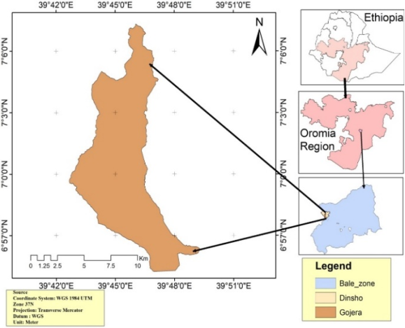
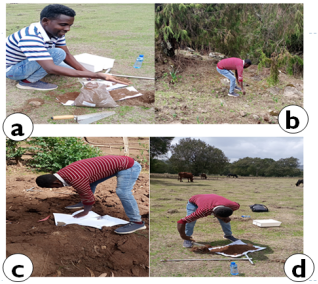
Understanding the effects of different land use types on soil physicochemical properties (PCPs) is essential for the sustainable management of soil resources and environmental conservation. This study aimed to evaluate the impact of various land use types on selected soil PCPs in the Dinsho district of Ethiopia. A total of 32 soil samples were collected from four land use types: forests, agricultural farms, grazing areas, and grasslands, at two soil depths (0–20 cm and 20–40 cm), with three replicates per type. The mean differences in physical and chemical parameters were analyzed using a two-way analysis of variance. The results indicated that agricultural land and grasslands exhibited the highest values for sand and clay content. Forested areas showed significantly higher levels of SOM at 5.05% and TN with a p-value of less than 0.001. The mean available phosphorus ranged from 2.03 to 5.2 mg/kg, indicating a significant deficiency of available phosphorus in the study area. The mean bulk density and total porosity of the soils ranged from 1.14 to 1.37 g/cm³ and 42.02% to 51.5%, respectively, which are higher than the desirable limits for optimal soil health. The pH values ranged from 6.06 to 7.25, falling within an acceptable range. Additionally, the exchangeable basic cations, CEC, and PBS values were classified as high to very high across all land use types. These findings suggest that inappropriate land use practices significantly affect soil physicochemical properties, leading to detrimental effects on soil quality. Therefore, it is crucial to implement Land?Use Planning and Environmental Impact Assessment (EIA) strategies to ensure the sustainable use of soil resources and promote environmental conservation.
| Published in | Journal of Energy, Environmental & Chemical Engineering (Volume 11, Issue 1) |
| DOI | 10.11648/j.jeece.20261101.12 |
| Page(s) | 12-27 |
| Creative Commons |
This is an Open Access article, distributed under the terms of the Creative Commons Attribution 4.0 International License (http://creativecommons.org/licenses/by/4.0/), which permits unrestricted use, distribution and reproduction in any medium or format, provided the original work is properly cited. |
| Copyright |
Copyright © The Author(s), 2026. Published by Science Publishing Group |
Soil Quality, Land Use Types, Dinsho District, Soil Physicochemical Analysis
Land use types | Sand (%) | Silt (%) | Clay (%) | BD gm./cm-3 | TP (%) | |||||
|---|---|---|---|---|---|---|---|---|---|---|
Soil depth (cm) | Soil depth (cm) | Soil depth (cm) | Soil depth | Soil depth (cm) | ||||||
0-20 | 20-40 | 0-20 | 20-40 | 0-20 | 20-40 | 0-20 | 20-40 | 0-20 | 20-40 | |
Forestland | 23.5 | 27.35 | 33.8 | 39.5m | 47.0 | 38.6n | 1.23b | 1.26d | 45.42b | 46.54n |
Farm land | 36.3 | 28.35 | 24.7 | 23.8n | 40.1 | 52.2n | 1.39n | 1.35m | 51.45a | 50.94a |
Grazing land | 28.5 | 26.1 | 29.7 | 31.6mn | 42.7 | 43.5mn | 1.37n | 1.34n | 50.97c | 49.57a |
Grass land | 26.0 | 24.7 | 27.0 | 26.0n | 50.0 | 51.3n | 1.08m | 1.20a | 39.75a | 44.28b |
Mean | 28.58 | 26.63 | 28.8 | 30.2 | 44.95 | 46.3 | 1.27 | 1.29 | 46.90 | 47.83 |
SD | 5.55 | 4.86 | 5.92 | 4.84 | 7.7 | 5.76 | 0.0073 | 0.0085 | 0.29 | 0.28 |
CV (%) | 19.3 | 18.25 | 20.6 | 16.0 | 17.1 | 12.45 | 0.578 | 0.65 | 0.605 | 0.58 |
P Values | Ns | Ns | Ns | * | ns | * | *** | *** | *** | *** |
Managements | Sand (%) | Silt (%) | Clay (%) | BD (%) | TP (%) |
|---|---|---|---|---|---|
Land uses types | |||||
Forestland | 25.4 | 36.7 | 42.8mn | 1.25m | 45.98d |
Farm land | 32.3 | 24.3 | 46.2m | 1.37c | 51. 20c |
Grazing land | 27.3 | 30.6 | 43.1mn | 1.36d | 50.27c |
Grass land | 25.4 | 26.5 | 50.65n | 1.14n | 42.02m |
Soil depth (cm) | |||||
0-20 | 27.1 | 28.5 | 44.45 | 1.26m | 47.8c |
20-40 | 25.3 | 29.1 | 45.58 | 1.28n | 48.46b |
Land use | Ns | * | * | *** | *** |
Depth | Ns | Ns | Ns | ** | ** |
Land use system | PH | EC (S/m) | CaCO3 (ppm) | |||
|---|---|---|---|---|---|---|
Soil depth (cm) | Soil depth (cm) | Soil depth (cm) | ||||
0-20 | 20-40 | 0-20 | 20-40 | 0-20 | 20-40 | |
Forestland | 7.1a | 7.2m | 0.59n | 0.47b | 10.8a | 9.09m |
Farm land | 5.82b | 6.3ab | 0.34m | 0.35ac | 6.5c | 7.1a |
Grazing land | 6.8c | 7.0n | 0.32m | 0.36ac | 5.2d | 5.65c |
Grass land | 6.9d | 7.1m | 0.31m | 0.35c | 7.82b | 9.1m |
Mean | 6.7 | 6.9 | 0.39 | 0.28 | 7.56 | 7.74 |
St. Deviation | 0.28 | 0.30 | 0.08 | 0.07 | 0.40 | 0.33 |
CV (%) | 4.2 | 4.4 | 20.50 | 25.0 | 5.3 | 4.3 |
P Values | ** | * | ** | * | *** | *** |
Land use system | TN (%) | TOC (%) | SOM (%) | C: N (%) | Av. P (%) | |||||
|---|---|---|---|---|---|---|---|---|---|---|
Soil depth (cm) | Soil depth (cm) | Soil depth (cm) | Soil depth (cm) | Soil depth (cm) | ||||||
0-20 | 20-40 | 0-20 | 20-40 | 0-20 | 20-40 | 0-20 | 20-40 | 0-20 | 20-40 | |
Forestland | 0.27ab | 0.22mn | 3.21c | 2.70a | 5.7mn | 4.40 | 11.85 | 10.80d | 6.80b | 3.60a |
Farm land | 0.21b | 0.20mn | 2.35b | 1.90b | 3.7m | 3.30 | 11.75 | 10.65c | 4.75c | 3.05mn |
Grazing land | 0.20c | 0.16a | 2.19d | 1.65c | 3.6m | 2.74 | 10.5 | 10.30b | 2.74a | 1.83m |
Grass land | 0.25b | 0.20b | 2.87a | 2.19d | 4.6n | 3.60 | 11.5 | 10.95c | 3.32d | 2.08n |
Mean | 0.23 | 0.20 | 2.67 | 2.11 | 4.4 | 3.51 | 11.52 | 10.51 | 3.44 | 1.94 |
St. Deviation | 0.03 | 0.02 | 0.14 | 0.27 | 0.24 | 0.47 | 0.96 | 0.91 | 0.72 | 0.20 |
CV (%) | 13.0 | 10 | 5.24 | 12.80 | 5.5 | 13.39 | 8.33 | 866 | 20.9 | 10.3 |
P Values | *** | ** | ** | * | *** | * | * | Ns | *** | * |
Treatments | pH | EC | CaCO3 | TOC | SOM | TN | C: N | Av. P |
|---|---|---|---|---|---|---|---|---|
(S/m) | (ppm) | (%) | (%) | (%) | (mgkg-1) | |||
land use types | ||||||||
Forestland | 7.25a | 0.52n | 9.95a | 3.00n | 5.05a | 0.25c | 11.33a | 5.2ba |
Farm land | 6.06c | 0.34m | 6.8b | 2.13m | 3.5b | 0.21a | 11.35a | 3.9c |
Grazing land | 6.9b | 0.34m | 5.43c | 1.92c | 3.17c | 0.18b | 10.4b | 2.30a |
Grass land | 7.0d | 0.31mn | 8.46d | 2.53mn | 4.1d | 0.23a | 11.23c | 2.7d |
Soil depth (cm) | ||||||||
0-20 | 6.70a | 0.39 | 7.58 | 2.70a | 4.4a | 0.23n | 10.7 | 4.40a |
20-40 | 6.90b | 0.37 | 7.74 | 2.11b | 3.51b | 0.20m | 10.5 | 2.64b |
Land use system | *** | ** | *** | *** | *** | *** | * | *** |
Soil depth | *** | Ns | Ns | ** | ** | ** | Ns | *** |
CV (%) | 4.10 | 20.26 | 4.5 | 9.5 | 10.10 | 9.6 | 8.48 | 27.5 |
Na+ | K+ | Ca2+ | CEC | PBS | ||||||
|---|---|---|---|---|---|---|---|---|---|---|
c molc kg-1 % | ||||||||||
Soil depth (cm) | Soil depth (cm) | Soil depth (cm) | Soil depth (cm) | Soil depth (cm) | ||||||
Land use systems | 0-20 | 20-40 | 0-20 | 20-40 | 0-20 | 20-40 | 0-20 | 20-40 | 0-20 | 20-40 |
Forestland | 0.45 | 0.49 | 1.62c | 1.3 | 26.5b | 22.3a | 44.50 | 40.42b | 67.23b | 78.5c |
Farm land | 0.43 | 0.47 | 0.74a | 0.85 | 17.8c | 21.8ab | 34.5 | 35.20a | 59.0d | 78.6c |
Grazing land | 0.43 | 0.44 | 0.45b | 0.49 | 16.2c | 17.4c | 28.12 | 29.35c | 55.14c | 74.72a |
Grass land | 0.44 | 0.47 | 0.65a | 0.69 | 24.3a | 25.70b | 37.43 | 39.62b | 64.8b | 80.2c |
Mean | 0.44 | 0.47 | 0.87 | 0.83 | 21.2 | 21.8 | 36.14 | 36.08 | 61.54 | 78.01 |
St. deviation | 0.08 | 0.07 | 0.19 | 0.11 | 0.74 | 1.17 | 1.28 | 2.4 | 1.07 | 2.3 |
CV (%) | 18.2 | 14.89 | 21.80 | 13.25 | 3.49 | 5.37 | 3.54 | 6.65 | 1.7 | 2.95 |
P values | Ns | Ns | ** | Ns | *** | * | *** | ** | *** | * |
Treatments | Na+ | K+ | Ca2+ | CEC | PBS |
|---|---|---|---|---|---|
cmolc kg-1% | |||||
Land use system | |||||
Forestland | 0.46 | 1.46 | 24.4 | 42.50 | 74.40 |
Farm land | 0.45 | 0.80 | 19.8 | 28.74 | 66.93 |
Grazing land | 0.43 | 0.47 | 16.8 | 34.85 | 66.80 |
Grass land | 0.44 | 0.67 | 25.0 | 38.53 | 74.0 |
Soil depth (cm) | |||||
0-20 | 0.43 | 0.88 | 21.2 | 36.1 | 61.5 |
20-40 | 0.46 | 0.83 | 20.8 | 36.15 | 78.0 |
Land use | Ns | ** | *** | * | *** |
Soil depth | Ns | Ns | ** | Ns | * |
Land use*depth | Ns | Ns | *** | Ns | *** |
AVp | Available Phosphorus |
BD | Bulk Density |
BZAO | Bale Zone Agricultural Office |
BMNP | Bale mountain National Park |
CEC | Cation Exchange Capacity |
C/N | Carbon-to-nitrogen Ratio |
CSA | Central Statistical Agency |
CV | Coefficient of Variation |
DWAO | Dinsho Woreda Agricultural Office |
EC | Electrical Conductivity |
FGD | Focus Group Discussion |
IFPRI | International Food Policy Research Institute |
ILCA | International Livestock Research Center for Africa |
ISRIC | International Soil Reference and Information Center |
MoFED | Ministry of Finance and Economic Development |
NPS | Nitrogen Phosphorus Sulfur |
NuMaSS | Nutrient Management Support System |
PASDEP | Plan for Accelerated Sustained Development to End Poverty |
PBS | Percent Base Saturation |
PCPs | Physicochemical Properties |
PD | Particle Density |
SOC | Soil Organic Carbon |
TOC | Total Organic Carbon |
| [1] | Tufa, M., Melese, A., & Tena, W. (2019). Effects of land use types on selected soil physical and chemical properties: The case of Kuyu District, Ethiopia. Eurasian journal of soil science, 8(2), 94-109. |
| [2] | Lisec, U., Prevolnik Povše, M., Gselman, A., & Kramberger, B. (2024). Sustainable Grassland-Management Systems and Their Effects on the Physicochemical Properties of Soil. Plants, 13(6), 838. |
| [3] | Grover, D., Mishra, A. K., Rani, P., Kalonia, N., Chaudhary, A., Sharma, S. (2024). Soil Management in Sustainable Agriculture: Principles and Techniques. In: Kumar, P., Aishwarya (eds) Technological Approaches for Climate Smart Agriculture. Springer, Cham. |
| [4] | Lemenih, M., 2004. Effects of land use changes on soil quality and native flora degradation and restoration in the highlands of Ethiopia (Vol. 306, No. 306). |
| [5] | Bore, G. and Bedadi, B., 2015. Impacts of land use types on selected soil physico-chemical properties of Loma Woreda, Dawuro Zone, Southern Ethiopia. Science, Technology and Arts Research Journal, 4(4), pp. 40-48. |
| [6] | Dragović, N., Vulević, T. (2020). Soil Degradation Processes, Causes, and Assessment Approaches. In: Leal Filho, W., Azul, A., Brandli, L., Lange Salvia, A., Wall, T. (eds) Life on Land. Encyclopedia of the UN Sustainable Development Goals. Springer, Cham. |
| [7] | Aytenew, M. and Kibret, K., 2016. Assessment of soil fertility status at Dawja watershed in Enebse Sar Midir district, Northwestern Ethiopia. International journal of plant & soil science, 11(2), pp. 1-13. |
| [8] | Fang, H., Zhai, Y. & Li, C. (2024). Evaluating the impact of soil erosion on soil quality in an agricultural land, northeastern China. Sci Rep 14, 15629. |
| [9] | Pavlů, Lenka, Luboš Borůvka, Antonín Nikodem, Marcela Rohošková, and Vít Penížek. "Altitude and forest type effects on soils in the Jizera Mountains region Original Paper." Soil and Water Research 2, no. 2 (2007). |
| [10] | Adeyemo, A. J. and Agele, S. O., 2010. Effects of tillage and manure application on soil physicochemical properties and yield of maize grown on a degraded intensively tilled alfisol in southwestern Nigeria. Journal of Soil Science and Environmental Management, 1(8), pp. 205-216 |
| [11] | Jaleta Negasa, D., 2020. Effects of land use types on selected soil properties in central highlands of Ethiopia. Applied and Environmental Soil Science, 2020(1), p. 7026929. |
| [12] | Chemeda, M., Kibret, K. and Fite, T., 2017. Influence of different land use types and soil depths on selected soil properties related to soil fertility in Warandhab area, Horo Guduru Wallaga Zone, Oromiya, Ethiopia. International Journal of Environmental Sciences and Natural Resources, 4(2), p. 555634. |
| [13] | MoFED (2007). Ministry of finance and Economic development. PASDEP Annual progress Report 2006/07, Building on progress: A plan for Accelerated and sustained Development to End poverty (PASDEP 2005/06-2009/10). Addis Ababa. |
| [14] | FAO, (1998). Topsoil characterization for sustainable land management. (DRAFT). Food and Agriculture Organization, Land and Water Development Division, Soil Resources, ManagementandConservationService, Rome, Italy. Availableat: (accessdate: 18.05.2018): |
| [15] | Fentie, S. F., Jembere, K., Fekadu, E. and Wasie, D., 2020. Land use and land cover dynamics and properties of soils under different land uses in the tejibara watershed, Ethiopia. The Scientific World Journal, 2020(1), p. 1479460. |
| [16] | Asmare, T. K., Abayneh, B., Yigzaw, M. and Birhan, T. A., 2023. The effect of land use type on selected soil physicochemical properties in Shihatig watershed, Dabat district, Northwest Ethiopia. Heliyon, 9(5). |
| [17] | Debebe, W., Yirgu, T. and Debele, M., 2024. Dynamics of Soil Physical and Chemical Properties under Different Current Land Use Types and Elevation Gradients in the Sala Watershed of Ari Zone, South Ethiopia. Applied and Environmental Soil Science, 2024(1), p. 7389265. |
| [18] | DWAO (Dinsho Agricultural Office, (2022). Annual reported data on land use systems. Unpublished document, Bale Zone, Ethiopia. |
| [19] | Ryan, J., Estefan, G. and Rashid, A., 2001. Soil and plant analysis laboratory manual. ICARDA. |
| [20] | Bouyoucos, G. J., 1962. Hydrometer method improved for making particle size analyses of soils 1. Agronomy journal, 54(5), pp. 464-465. |
| [21] | Van-Reeuwijk, L., (1992). Procedures for Soil Analysis (3rd ed.), International Soil Reference and information Center (ISRIC). Wageningen. The Netherlands. |
| [22] | Olsen, S. R., 1954. Estimation of available phosphorus in soils by extraction with sodium bicarbonate (No. 939). US Department of Agriculture. |
| [23] | Rowell, D. L., 2014. Soil science: Methods & applications. Routledge. |
| [24] | Chapman, H. D., 1965. Cation‐exchange capacity. Methods of soil analysis: Part 2 Chemical and microbiological properties, 9, pp. 891-901. |
| [25] | Landon, J. R., 2014. Booker tropical soil manual: a handbook for soil survey and agricultural land evaluation in the tropics and subtropics. Routledge. |
| [26] | Mezgebe, T., 2014. Effects of Land Use/cover Changes on Soil properties in a Dryland Watershed of Hirmi and its Adjacent Agro Ecosystem: Northern Ethiopia. |
| [27] | Abbasi, M. K., Zafar, M. and Khan, S. R., 2007. Influence of different land-cover types on the changes of selected soil properties in the mountain region of Rawalakot Azad Jammu and Kashmir. Nutrient Cycling in Agroecosystems, 78, pp. 97-110. |
| [28] | Mustapha, S. (2007). Physico-chemical properties and fertility status of some Haplic Plinthaquults in Bauchilocal government area of Bauchi State, Nigeria. International Journal of Soil Science investigation of environmental influences on the acetate and methane formation in solid waste management, 24: 763–773. |
| [29] | Takele, L., Chimdi, A., Abebaw, A., (2014). Dynamics of Soil fertility as ınfluenced by different land use systems and soil depth in West Showa Zone, Ginde Beret District, Ethiopia. Agriculture, Forestry and Fisheries, 3(6): 489-494. |
| [30] | Tekalign, T., (1991). Soil, plant, water, fertilizer, animal manure and compost analysis. Working Document No. 13. International Livestock Research Center for Africa (ILCA), Addis Ababa, Ethiopia. |
| [31] | Mesele, S., Gebrekidan, H., Gizachew, L., Layne, C., (2006). Changes in land cover and soil conditions for theYabelodistrictof the Borana plateau, 1973-2003. Global Livestock Collaborative Research Support Program. University of California, Davis. 4. |
| [32] |
Gebrelibanos, H. and Negassa, W., 2006. Inmpact of Land use and management practices on Chemical properties of some soils of Bako area, Western Ethiopia. Ethiopian Journal of Natural Resources.
https://agris.fao.org/search/en/providers/122600/records/64724d3e53aa8c8963059852 |
| [33] | Chibsa, T. and Ta, A. A., 2009. Assessment of soil organic matter under four land use systems in the major soils of bale highlands, South East Ethiopia b. Factors affecting soil organic matter distribution. World Applied Sciences Journal, 6(11), pp. 1506-1512. |
| [34] | Duguma, L. A., Hager, H. E. and Sieghardt, M. O., 2010. Effects of land use types on soil chemicalproperties in smallholder farmers of central highland Ethiopia. Ekológia (Bratislava. Ekologia, 29(1), pp. 1-14. |
| [35] | Elias, E., 2017. Characteristics of Nitisol profiles as affected by land use type and slope class in some Ethiopian highlands. Environmental Systems Research, 6(1), pp. 1-15. |
| [36] | Yadda, F. and Abdulkadir, A., 2011. The effect of cropland fallowing on soil nutrient restoration in the Bale Mountains, Ethiopia. Journal of Science and Development, 1(1), pp. 43-51. |
| [37] | Negassa W., (2001). “Assessment of important physico chemical properties of nitosols under different management systems in bako area, western Ethiopia,”M. Sc. Thesis. Haramaya University, Dire Dawa, Ethiopia. 109. |
| [38] | Yitbarek, T., Gebrekidan, H., Kibret, K. and Beyene, S., 2013. Impacts of land use on selected physicochemical properties of soils of Abobo area, western Ethiopia. Agriculture, Forestry and Fisheries, 2(5), pp. 177-183. |
| [39] | Kiflu, A. and Beyene, S., 2013. Effects of different land use systems on selected soil properties in South Ethiopia. Journal of soil science and Environmental Management, 4(5), pp. 100-107. |
| [40] | Abebe, N. and Endalkachew, K., 2011. Impact of biomass burning on selected physicochemical properties of nitisol in Jimma zone, Southwestern Ethiopia. International Research Journal of Agricultural science and soil science, 1(9), pp. 394-401. |
| [41] | Hazelton, P. and Murphy, B., 2016. Interpreting soil test results: What do all the numbers mean?. CSIRO publishing. |
| [42] | Walkley, A., Black, I. A., (1934). An examination of Degtjareff method for determining soil organic matter and a proposed modification of the chromic acid titration method. Soil Science, 37(1): 29-37. |
| [43] | FAO, (2006). Plant Nutrition for Food Security: A guide for integrated nutrient management. FAO Fertilizer and Plant Nutrition Bulletin No. 16, Food and Agriculture Organization, Rome, Italy. Availableat: (accessdate: 18.05.2018): |
APA Style
Jara, Y. S., Gari, A. N. (2026). Environmental Conservation: Effects of Land Use Types on Soil Physicochemical Properties in Gojera Kebele, Southeastern Ethiopia. Journal of Energy, Environmental & Chemical Engineering, 11(1), 12-27. https://doi.org/10.11648/j.jeece.20261101.12
ACS Style
Jara, Y. S.; Gari, A. N. Environmental Conservation: Effects of Land Use Types on Soil Physicochemical Properties in Gojera Kebele, Southeastern Ethiopia. J. Energy Environ. Chem. Eng. 2026, 11(1), 12-27. doi: 10.11648/j.jeece.20261101.12
AMA Style
Jara YS, Gari AN. Environmental Conservation: Effects of Land Use Types on Soil Physicochemical Properties in Gojera Kebele, Southeastern Ethiopia. J Energy Environ Chem Eng. 2026;11(1):12-27. doi: 10.11648/j.jeece.20261101.12
@article{10.11648/j.jeece.20261101.12,
  author = {Yohannes Shuka Jara and Alemu Nigussie Gari},
  title = {Environmental Conservation: Effects of Land Use Types on Soil Physicochemical Properties in Gojera Kebele, Southeastern Ethiopia},
  journal = {Journal of Energy, Environmental & Chemical Engineering},
  volume = {11},
  number = {1},
  pages = {12-27},
  doi = {10.11648/j.jeece.20261101.12},
  url = {https://doi.org/10.11648/j.jeece.20261101.12},
  eprint = {https://article.sciencepublishinggroup.com/pdf/10.11648.j.jeece.20261101.12},
  abstract = {Understanding the effects of different land use types on soil physicochemical properties (PCPs) is essential for the sustainable management of soil resources and environmental conservation. This study aimed to evaluate the impact of various land use types on selected soil PCPs in the Dinsho district of Ethiopia. A total of 32 soil samples were collected from four land use types: forests, agricultural farms, grazing areas, and grasslands, at two soil depths (0–20 cm and 20–40 cm), with three replicates per type. The mean differences in physical and chemical parameters were analyzed using a two-way analysis of variance. The results indicated that agricultural land and grasslands exhibited the highest values for sand and clay content. Forested areas showed significantly higher levels of SOM at 5.05% and TN with a p-value of less than 0.001. The mean available phosphorus ranged from 2.03 to 5.2 mg/kg, indicating a significant deficiency of available phosphorus in the study area. The mean bulk density and total porosity of the soils ranged from 1.14 to 1.37 g/cm³ and 42.02% to 51.5%, respectively, which are higher than the desirable limits for optimal soil health. The pH values ranged from 6.06 to 7.25, falling within an acceptable range. Additionally, the exchangeable basic cations, CEC, and PBS values were classified as high to very high across all land use types. These findings suggest that inappropriate land use practices significantly affect soil physicochemical properties, leading to detrimental effects on soil quality. Therefore, it is crucial to implement Land?Use Planning and Environmental Impact Assessment (EIA) strategies to ensure the sustainable use of soil resources and promote environmental conservation.},
 year = {2026}
}
TY  - JOUR
T1  - Environmental Conservation: Effects of Land Use Types on Soil Physicochemical Properties in Gojera Kebele, Southeastern Ethiopia
AU  - Yohannes Shuka Jara
AU  - Alemu Nigussie Gari
Y1  - 2026/02/21
PY  - 2026
N1  - https://doi.org/10.11648/j.jeece.20261101.12
DO  - 10.11648/j.jeece.20261101.12
T2  - Journal of Energy, Environmental & Chemical Engineering
JF  - Journal of Energy, Environmental & Chemical Engineering
JO  - Journal of Energy, Environmental & Chemical Engineering
SP  - 12
EP  - 27
PB  - Science Publishing Group
SN  - 2637-434X
UR  - https://doi.org/10.11648/j.jeece.20261101.12
AB  - Understanding the effects of different land use types on soil physicochemical properties (PCPs) is essential for the sustainable management of soil resources and environmental conservation. This study aimed to evaluate the impact of various land use types on selected soil PCPs in the Dinsho district of Ethiopia. A total of 32 soil samples were collected from four land use types: forests, agricultural farms, grazing areas, and grasslands, at two soil depths (0–20 cm and 20–40 cm), with three replicates per type. The mean differences in physical and chemical parameters were analyzed using a two-way analysis of variance. The results indicated that agricultural land and grasslands exhibited the highest values for sand and clay content. Forested areas showed significantly higher levels of SOM at 5.05% and TN with a p-value of less than 0.001. The mean available phosphorus ranged from 2.03 to 5.2 mg/kg, indicating a significant deficiency of available phosphorus in the study area. The mean bulk density and total porosity of the soils ranged from 1.14 to 1.37 g/cm³ and 42.02% to 51.5%, respectively, which are higher than the desirable limits for optimal soil health. The pH values ranged from 6.06 to 7.25, falling within an acceptable range. Additionally, the exchangeable basic cations, CEC, and PBS values were classified as high to very high across all land use types. These findings suggest that inappropriate land use practices significantly affect soil physicochemical properties, leading to detrimental effects on soil quality. Therefore, it is crucial to implement Land?Use Planning and Environmental Impact Assessment (EIA) strategies to ensure the sustainable use of soil resources and promote environmental conservation.
VL  - 11
IS  - 1
ER  -
Department of Chemistry, Borana University, Yabello, Ethiopia
Biography: Yohannes Shuka Jara 29 year young Ethiopian Chemist, who is now a PhD Candidate at the University of Messina (UniME), Italy. He previously served as Chief-in lab chemist at Madda Walabu University and as a Lecturer and Researcher of Physical Chemistry at Borana University in Ethiopia. Since 2020, he has been a scientific article author and paper reviewer. Yohannes graduated with distinction in Applied Chemistry from Dilla University in 2019 and earned an MSc in Physical Chemistry from Hawassa University in June 2024, where he was honored with the Presidential Award for Excellence for his outstanding academic achievements. To date, I have published eight works in reputable journals, with three more currently in the publication process. He looks forward to learning and sharing efforts with you through fellowship and professional collaboration.

Information