Abstract
Under the urban-rural integration strategy, county centers are assigned the pivotal role of bridging higher-level administrative units and lower-level towns and villages. However, rural residents' higher-order center travel increasingly bypasses county centers and goes directly to city centers, a hierarchical leap that contradicts the distance decay principle of central place theory. Drawing on mobile phone signaling data from Ningbo and semi-structured interviews with 30 rural residents, this study adopts a mixed-methods approach to reveal the spatial decay pattern of rural residents' county-level trips and the underlying mechanisms on micro-level in China. Quantitative analysis reveals that the daily number of county-level trips decays in a core–periphery concentric pattern. Findings show that in remote townships, more than 30 km from the county center, county-level trips fall below 15 per day, while city-level trips remain a stable substitute at 10 to 30 per day in these outlying areas. Qualitative analysis explains that the reasons rural residents bypass the county center include social ties, the mismatches between perceived and objective accessibility, the hierarchical differentiation of travel demands, and individual capability constraints. By triangulating quantitative and qualitative evidence, this study extends the understanding of administrative hierarchies and service access in central place theory under the context of Chinese urban-rural integration.
|
Published in
|
Urban and Regional Planning (Volume 11, Issue 3)
|
|
DOI
|
10.11648/j.urp.20261103.12
|
|
Page(s)
|
152-163 |
|
Creative Commons
|

This is an Open Access article, distributed under the terms of the Creative Commons Attribution 4.0 International License (http://creativecommons.org/licenses/by/4.0/), which permits unrestricted use, distribution and reproduction in any medium or format, provided the original work is properly cited.
|
|
Copyright
|
Copyright © The Author(s), 2026. Published by Science Publishing Group
|
Keywords
Urban-rural Integration, Higher-order Center Travel, County Center, Mixed Methods, Ningbo
1. Introduction
Urban-rural integration serves as a core strategic pathway for dismantling the urban-rural dual structure and advancing rural revitalization in China. Within the Chinese “city–county–town–village” administrative and spatial hierarchy, county centers are assigned the pivotal bridging function linking the urban and the rural. The Chinese central government explicitly proposed “urbanization with county towns as important carriers.” County centers are accordingly expected to function not only as the core carriers of county urbanization but also as the primary parts through which rural residents' access high-order public services such as education, healthcare, and commerce. However, a national surveys in recent years have uncovered a contradictory travel phenomenon: when accessing high-order services, township residents increasingly bypass county centers and travel directly to city centers. Zhao et al found that small-town residents' shopping trips exhibit a structure characterized by frequent travel to town and city centers but infrequent visits to county centers
. This phenomenon indicates a diminishing role of county centers.
Existing research on rural residents' travel behavior has accumulated rich findings. At the macro level, mobile phone signaling data are widely used to analyze the spatial differentiation of trip OD (Origin–Destination) flows, trip frequencies, and travel distances, revealing an uneven distribution pattern across town, county, and city levels
| [2] | Zhengying Liu, Pengjun Zhao, Qiyang Liu, Zhangyuan He, Tingting Kang. Uncovering spatial and social gaps in rural mobility via mobile phone big data. Scientific Reports. 2023, 13(1), 64-69.
https://doi.org/10.1038/s41598-023-33123-0 |
| [3] | Miaoxi Zhao, Ying Xu. Exploration of mobile signaling in village and town settlement network connections: A case study of three towns in Zhongshan. Shanghai Urban Planning. 2019, (06), 38-45. |
| [4] | Lin Tian, Yao Cheng, Xinyi Niu. Spatial organization of town and village areas in the network perspective: An analysis of resident cross-village travel links in Lin'an district, Hangzhou. Urban Planning Forum. 2023, (01), 104-110.
https://doi.org/10.16361/j.upf.202301015 |
[2-4]
. At the micro level, in-depth interviews and questionnaire surveys have uncovered the influence of the built environment, psychological perceptions, and other factors on travel decision-making
| [5] | Zhao Yu, Pengjun Zhao. The factors in residents’ mobility in rural towns of China: Car ownership, road infrastructure and public transport services. Journal of Transport Geography. 2021, 91:102950.
https://doi.org/10.1016/j.jtrangeo.2021.102950 |
| [6] | Qiyang Liu, Zhengying Liu, Zhao Yu, Pengjun Zhao. The living environment and intravillage activity-travel: A conceptual framework based on participant observation in Guangdong, China. Journal of Rural Studies. 2023, 99, 121-133. https://doi.org/10.1016/j.jrurstud.2023.03.006 |
[5, 6]
. However, signaling data-based studies cannot explain why rural residents prefer more distant city centers over closer county centers. Interview-based studies identify the role of micro factors such as perceived accessibility but fail to confirm their spatial prevalence. Thus, a systematic framework integrating macro-level spatial pattern analysis and micro-level behavioral mechanism analysis is necessary. Furthermore, existing studies largely focused on the objective built environment or individual socioeconomic attributes. Consequently, there is a lack of systematic understanding regarding how rural residents bypass county centers. Specifically, little is known about how this behavior is jointly driven by social ties, mismatches between perceived and actual accessibility, hierarchical needs, and individual capability constraints.
To fill these gaps, this study takes Ningbo, Zhejiang Province, as a case and adopts a mixed-methods approach that combines mobile phone signaling big data with semi-structured interviews to investigate the weakening of county centers in rural residents' high-order center travel. Specifically, we aim to answer three questions: (1) What spatial pattern characterizes rural residents' travel to town, county, and city centers? (2) What are the decision-making mechanisms behind rural residents' bypassing of county centers in favor of city centers? (3) How do quantitative and qualitative evidence corroborate each other to reveal the mechanism of a diminishing role of county centers? The theoretical contribution of this paper lies in integrating macro-level spatial patterns with micro-level behavioral mechanisms. By contextually extending the distance decay principle of central place theory, we identify service quality gaps, social network orientation, and perceived accessibility as key variables. Methodologically, the triangulated framework provides a transferrable model for empirically diagnosing hierarchical service gaps in rural regions. From a regional planning perspective, the revealed trip patterns and bypassing behaviors carry critical implications for redefining county centers' functional roles and recalibrating the spatial equity of infrastructure investments in remote areas.
The paper is organized as follows. Section 2 reviews the literature. Section 3 describes the research design and methods. Section 4 presents the empirical findings. Section 5 offers an integrated discussion, triangulating the quantitative and qualitative evidence. Section 6 concludes with the main findings, policy recommendations, and limitations.
2. Literature Review
The study of rural residents' high-order center travel behavior is an important topic in the fields of urban-rural planning and transport geography. Existing research has accumulated rich findings at both the macro level of travel patterns and the micro level of behavioral mechanisms, yet the micro-level explanation for the specific phenomenon of county center weakening remains to be deepened.
At the macro level of travel patterns, mobile phone signaling data and other big-data methods provide strong support for revealing rural residents' travel characteristics to centers of different tiers. Drawing on mobile phone signaling data, Zhao and Xu analyzed the network connections of village and town settlements and found that town centers play a core role in rural residents' daily travel
| [3] | Miaoxi Zhao, Ying Xu. Exploration of mobile signaling in village and town settlement network connections: A case study of three towns in Zhongshan. Shanghai Urban Planning. 2019, (06), 38-45. |
[3]
. Huang et al. further found that rural residents in Guizhou and Shaanxi visit town centers more frequently than county and city centers, a trend consistent across different types of counties
| [7] | Xiaoyan Huang, Yifan Xia, Chun Yin. Associations between the built environment and travel to higher-order centers in Chinese rural areas. Journal of Transport Geography. 2024, 119, 103956. https://doi.org/10.1016/j.jtrangeo.2024.103956 |
[7]
. Approximately 67% of respondents visit the town center at least once a week. Most respondents visit county centers and city centers on a monthly or seasonal basis, accounting for 34% and 46% of respondents, respectively. Based on a nationwide study of small towns, Zhao et al found that small-town residents' shopping trips increasingly connect to the county and city levels, exhibiting a leapfrog concentric structure described as “strong at both ends and weak in the middle,” where the proportions of trips within the town and city realms are high, representing a new trend that departs from the distance decay principle of central place theory
. These studies consistently indicate that county centers hold a lower actual status in township residents' travel structure than their administrative hierarchy would suggest, a phenomenon this paper terms the diminishing role of county centers
| [8] | Julian Hine, Md. Kamruzzaman, Neale Blair. Weekly activity-travel behaviour in rural northern Ireland: Differences by context and socio-demographic. Transportation. 2012, 39(1), 175-195. https://doi.org/10.1007/s11116-011-9322-4 |
| [9] | Hugh Millward, Jamie Spinney. Time use, travel behavior, and the rural–urban continuum: Results from the Halifax STAR project. Journal of Transport Geography. 2011, 19(1), 51-58. https://doi.org/10.1016/j.jtrangeo.2009.12.005 |
| [10] | Pengjun Zhao, Zhao Yu. Rural poverty and mobility in China: A national-level survey. Journal of Transport Geography. 2021, 93, 103083. https://doi.org/10.1016/j.jtrangeo.2021.103083 |
[8-10]
. However, existing macro-level research largely remains at the level of pattern description and lacks an in-depth mechanistic explanation of why county centers are marginalized.
At the micro level of behavioral mechanisms, scholars have explored the determinants of travel decision-making from the dimensions of individual socioeconomic attributes, the built environment, and psychological perceptions. Regarding individual attributes, gender, age, income, and car ownership have been shown to significantly influence travel frequency and destination choice
| [11] | Gina Porter, Kate Hampshire, Albert Abane, Augustine Tanle, Kobina Esia-Donkoh, Regina Obilie Amoako-Sakyi, Samuel Agblorti, Samuel Asiedu Owusu. Mobility, education and livelihood trajectories for young people in rural Ghana: A aender perspective. Children’s Geographies. 2011, 9(3-4), 395-410. https://doi.org/10.1080/14733285.2011.590705 |
| [12] | Gina Porter, Amleset Tewodros, Flavian Bifandimu, Mark Gorman, Amanda Heslop, Elisha Sibale, Abdul Awadh, Lorraine Kiswaga. Transport and mobility constraints in an aging population: health and livelihood implications in rural Tanzania. Journal of Transport Geography. 2013, 30, 161-169.
https://doi.org/10.1016/j.jtrangeo.2013.05.001 |
| [13] | Zhao Yu, Peilin Li, Tim Schwanen, Pengjun Zhao, Zhifeng Zhao. Role of rural built environment in travel mode choice: Evidence from China. Transportation Research Part D: Transport and Environment. 2023, 117, 103649.
https://doi.org/10.1016/j.trd.2023.103649 |
[11-13]
. As for the built environment, road conditions, public transit services, and the service capability of destinations jointly shape objective accessibility
| [5] | Zhao Yu, Pengjun Zhao. The factors in residents’ mobility in rural towns of China: Car ownership, road infrastructure and public transport services. Journal of Transport Geography. 2021, 91:102950.
https://doi.org/10.1016/j.jtrangeo.2021.102950 |
| [14] | Zihua Chen, Xiaowei Li, Bingzhi Liu, Shaohua Wang, Xiao Li, Jiaxin Li, Xiaohui Yang, Zhenbo Wang. Public transport accessibility in villages in and around major Chinese cities. Nature Cities. 2025, 2(8), 749-758.
https://doi.org/10.1038/s44284-025-00277-z |
[5, 14]
. Objective conditions, however, do not determine travel behavior directly but operate through individuals' subjective perceptions
| [15] | Jan Andersson, Gunilla Björklund, Henriette Wallén Warner, Katrin Lättman, Emeli Adell. The Complexity of Changes in Modal Choice: A Quasi-Experimental Study. Transportation Research Part F: Traffic Psychology and Behaviour. 2023, 96, 36-47. https://doi.org/10.1016/j.trf.2023.05.015 |
[15]
. Morris et al classically argued that perceived accessibility constitutes the direct basis for travel decisions
. Negm et al further confirmed a positive association between perceived accessibility and travel frequency
. In rural settings, infrequent bus services and complex transfers to the county centers significantly dampen rural residents' travel willingness
| [5] | Zhao Yu, Pengjun Zhao. The factors in residents’ mobility in rural towns of China: Car ownership, road infrastructure and public transport services. Journal of Transport Geography. 2021, 91:102950.
https://doi.org/10.1016/j.jtrangeo.2021.102950 |
[5]
. The concept of “Ease of Travel” advanced by De Vos et al integrates four dimensions (motivation, skills, external options, and travel quality), offering a comprehensive lens for understanding travel decisions
| [18] | Jonas De Vos, Long Cheng, Yuerong Zhang, Kailai Wang, Milad Mehdizadeh, Mengqiu Cao. The effect of ease of travel on travel behaviour and perceived accessibility: A focus on travel to university campus. Transportation Research Part F: Traffic Psychology and Behaviour. 2025, 109, 1170-1181.
https://doi.org/10.1016/j.trf.2025.01.035 |
[18]
; yet this framework is primarily grounded in Western urban contexts and has rarely been examined in China's rural settings.
Furthermore, the role of social network ties in rural residents' travel has yet to receive sufficient attention. Against the backdrop of China's family-centered culture and relational society, intergenerational support and interpersonal interactions may profoundly shape travel decisions. International studies have recognized the influence of social networks on travel behavior, for example, intergenerational support can compensate for the mobility constraints of older adults
| [19] | Jianping Zha, Liying Yan, Yuxuan Wang, Lamei He, Dandan Xu, Yu Yu. Demystifying intergenerational support from adult children in senior tourism consumption: Insights from large-scale household level survey data. Tourism Management Perspectives. 2025, 59, 101398.
https://doi.org/10.1016/j.tmp.2025.101398 |
[19]
, but such research largely focuses on specific vulnerable groups and lacks a systematic analysis of the social embeddedness mechanisms in the travel decisions of the general rural population. Domestic research, by contrast, has concentrated more on spatial–geographic factors and macro-policy contexts
| [20] | Yan Li. Vehicle ownership, sustainable mobility and well-being in rural China. Environment, Development and Sustainability. 2023, 26(5), 12545-12568.
https://doi.org/10.1007/s10668-023-03890-x |
| [21] | Huijuan Li, Teng Hu, Xinyu Ma, Baodong Cheng. The impact of transportation infrastructure on the regional economic integration in China: A CGE analysis. International Review of Economics and Finance. 2025, 99, 104045.
https://doi.org/10.1016/j.iref.2025.104045 |
| [22] | Yurun Wang, Pu Zhao, Senkai Xie Wenjia Zhang. Mesoscale structure in urban–rural mobility networks in the Pearl River Delta area: A weighted stochastic block modeling analysis. ISPRS International Journal of Geo-Information. 2023, 12(5), 183. https://doi.org/10.3390/ijgi12050183 |
| [23] | Weijing Wang, Sierra Espeland, Jesus M. Barajas, Dana Rowangould. Rural–nonrural divide in car access and unmet travel need in the United States. Transportation. 2025, 52(2), 507-536. https://doi.org/10.1007/s11116-023-10429-6 |
[20-23]
, with relatively limited engagement with sociocultural factors. Liu et al revealed the socially embedded characteristics of intra-village travel through participant observation
| [6] | Qiyang Liu, Zhengying Liu, Zhao Yu, Pengjun Zhao. The living environment and intravillage activity-travel: A conceptual framework based on participant observation in Guangdong, China. Journal of Rural Studies. 2023, 99, 121-133. https://doi.org/10.1016/j.jrurstud.2023.03.006 |
[6]
, yet their study did not extend to the context of high-order center travel. How social network ties shape rural residents' choices between county-level and city centers thus remains an open question.
Existing research is marked by a clear methodological divide. Macro-level pattern studies, which largely depend on quantitative data such as mobile phone signaling, are adept at revealing general connections and features but fall short in explaining the underlying causes; micro-level mechanism studies, which often use qualitative methods such as in-depth interviews, are skilled at explaining internal logic but struggle to confirm the spatial generalizability of their findings. These two strands have proceeded independently, lacking an analytical framework that integrates macro-level patterns with micro-level mechanisms. In recent years, mixed methods have gained increasing attention in travel research. For instance, Tao and Næss combined gradient boosting decision trees with qualitative interviews to uncover the nonlinear effects of the built environment on travel behavior and their causal mechanisms; Reimers et al employed a mixed-methods approach integrating questionnaire surveys and semi-structured interviews to examine the influence of the home environment on adolescents' active travel
| [24] | Tao Tao, Petter Næss. Exploring nonlinear built environment effects on driving with a mixed-methods approach. Transportation Research Part D: Transport and Environment. 2022, 111, 103443. https://doi.org/10.1016/j.trd.2022.103443 |
| [25] | Anne Kerstin Reimers, Isabel Marzi, Franziska Beck, Eliane Engels, Denise Renninger, Adrian Buttazzoni, Claus Krieger, Yolanda Demetriou. Active travel behaviour in the family environment: Protocol for the mixed-methods cross-sectional ARRIVE study. BMJ Open. 2022, 12(2), e056383.
https://doi.org/10.1136/bmjopen-2021-056383 |
[24, 25]
. These studies offer methodological reference for this paper, demonstrating that mixed methods can effectively bridge the gaps between the macro and the micro, and between the quantitative and the qualitative.
3. Research Design and Methods
3.1. Study Area
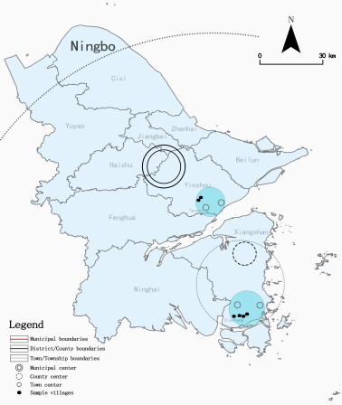
The study area is Ningbo, Zhejiang Province, located on the southern wing of the Yangtze River Delta. It comprises six districts, two counties, and two county-level cities, spanning an extensive area with a typical spatial urban-rural structure. As the primary economic center of the southern Yangtze River Delta, Ningbo features a high level of urban-rural integration, well-developed transport infrastructure, and comprehensive mobile phone signaling data, offering ideal data conditions for studying rural residents' high-order center travel. Furthermore, six administrative villages were selected as case sites among representative towns, as shown in
Figure 1.
Figure 1. Geographical locations of sampled villages and their higher-order centers.
3.2. Data Sources
The quantitative data were drawn from 31 consecutive days of mobile phone signaling data in Ningbo in March 2024. The raw data were processed by a DaaS (Data as a Service) platform into grid-level aggregated OD (origin–destination) data (grid size approximately 400m × 450m), yielding a total of 22.19 million OD records. In accordance with the National Bureau of Statistics' rules for compiling statistical division codes and urban-rural division codes, we selected trips with origins in “villages” and destinations in “town centers,” “county centers,” or “city centers,” obtaining approximately 346,000 valid OD records after cleaning. To highlight macro-level mobility patterns, spatial units were aggregated: multiple center polygon features of the same level within a township were merged, and their geometric centroid was taken as the representative center point; all village units within a township were merged, and their geometric centroid was computed as the trip origin.
Qualitative data were collected through two rounds of semi-structured interviews, conducted in October 2024 and February 2025. Purposive sampling with quota control was applied, considering age, income, occupation, and geographic location. In-depth interviews were held with 30 permanent village residents, each lasting 30 to 40 minutes. The interviews comprehensively covered travel purposes, reasons for destination choice, evaluations of county- and city-level services, social support, and travel difficulties. The demographic and socioeconomic profiles of the respondents are summarized in
Table 1.
Table 1. Respondent Basic Information.
Attribute dimension | Category | Number of people | Proportion |
Gender | Male/ | 13/ | 43.3%/ |
Female | 17 | 56.7% |
Age | Young (25-40)/ | 6/ | 20%/ |
Middle-aged (41-60)/ | 12/ | 40%/ |
Elderly (>60) | 12 | 40% |
Education | Primary school/ | 18/ | 60%/ |
Middle school/ | 9/ | 30%/ |
Senior high school/ | 1/ | 3.3% |
Bachelor | 2 | 6.7% |
Income (RMB) | <3000RMB/ | 8/ | 26.7%/ |
3000-9000RMB/ | 17/ | 56.7%/ |
>9000RMB | 5 | 16.7% |
Location | Remote suburban villages/ | 14/ | 46.7%/ |
Peri-urban villages | 16 | 53.3% |
3.3. Data Analysis Methods
Quantitative analysis is conducted through spatial visualization using mobile phone signaling data. At the township scale, we calculated the daily average number of trips (the average daily trips from all villages within a township to centers of the corresponding level) and the average travel distance (weighted average straight-line distance) for town-level, county-level, and city-level travel respectively. Spatial visualization was performed using ArcGIS, combined with descriptive statistics to analyze the spatial differentiation characteristics of the three-level travel.
For qualitative analysis, thematic analysis is employed based on information obtained from interviews. Interview recordings were transcribed verbatim and analyzed using thematic analysis in NVivo Plus 12.0 through a three-level coding process. In the open coding phase, initial concepts were extracted line by line, such as “my son drove me to the city”, “transfers to the county centers are a hassle”, “relatives are all in the city”, and “can get there directly by public transport”. In the axial coding phase, related codes were grouped into core categories, including “intergenerational support”, “perceived accessibility”, and “Health condition”. In the selective coding phase, core categories were integrated to identify the core four themes: social ties, mismatches between perceived and objective accessibility, hierarchical differentiation of travel needs, and individual capability constraints. Coding continued until thematic saturation was reached after the 24th interview. The resulting coding structure is summarized in
Table 2.
Table 2. Coding table of mechanisms underlying rural residents' bypassing of the county center.
Main themes | Sub-themes | Encoding example (Initial codes) |
Social ties | Intergenerational support | “My son works at the hospital. When I'm feeling very unwell, he comes to pick me up and take me to the hospital.” (Driving unwell mother to the city hospital) |
Interpersonal interaction | “I take the bus to the city center every year during Chinese New Year to visit relatives.” (Visiting relatives during holidays) |
Mismatches between perceived and objective accessibility | Objective accessibility | “Public transportation in the city goes directly to hospitals and business districts, and the transfer is very fast and convenient.” (Easy to transfer between public transport in the city) |
Perceived accessibility | “There is not much difference between going to the county and going to the city.” (The perception of travel time in county and urban areas is similar) |
Hierarchical differentiation of travel needs | Travel to town centers | “There are more goods in Tangxi Town, but few options in the village.” (Purchasing daily necessities) |
Travel to county centers | “I needed to go to the county center to get my driver's license.” (Getting driver's license in county area) |
Travel to city centers | “I usually take my family there for medical treatment.” (Traveling to urban area for healthcare purposes) |
Individual capability constraints | Health condition | “I'm old and I can't see clearly. I can't go too far.” (The elderly often go to town centers because of lack of physical strength) |
Car ownership | “I drive to the city centers for more than an hour, and less than an hour to the county center, but there are many kinds of things that can be bought in the city centers.” (Car groups tend to go to the city centers when they get higher service quality). |
3.4. Triangulation Design
This study adopts a triangulation design, combining quantitative and qualitative evidence to enhance the reliability and interpretive depth of the findings. Quantitative data capture the breadth and regularity of spatial patterns, while qualitative data explains the internal logic of decision-making mechanisms; the two are methodologically complementary mechanisms.
The integration of the two data types follows Greene et al dual framework of “complementarity” and “mutual confirmation”
| [26] | Jennifer C. Greene, Valerie J. Caracelli, Wendy F. Graham. Toward a conceptual framework for mixed-method evaluation designs. Educational Evaluation and Policy Analysis. 1989, 11(3), 255-274. https://doi.org/10.3102/01623737011003255 |
[26]
. Regarding complementarity, the spatial patterns revealed by quantitative analysis provide structured, question-oriented direction for qualitative thematic coding; the micro-level mechanisms distilled from qualitative analysis, in turn, offer causal explanations for the distributional features identified quantitatively. Regarding mutual confirmation, key quantitative findings and core qualitative themes are compared point by point to assess the degree of convergence between the two types of evidence.
Integration is implemented in three steps. First, based on quantitative results, we focus on townships exhibiting the most pronounced county-level trip decay, ensuring that the qualitative cases represent the key types of greatest explanatory value within the quantitative patterns. Second, spatial differentiation patterns revealed by quantitative analysis are incorporated into the coding framework as a priori themes in NVivo coding, while inductive themes emerging naturally from the interview corpus are retained. Finally, a joint display approach is used to juxtapose quantitative findings and qualitative explanations, systematically presenting the convergence and complementarity of the two types of evidence, and on this basis, distilling inferences that transcend the insights from either evidence source alone.
4. Results
4.1. Quantitative Results: Spatial Patterns
The OD flow analysis based on mobile phone signaling data reveals a markedly uneven spatial distribution of rural residents' travel intensity to town-level, county-level, and city centers in Ningbo. In terms of total trip volume, city-level travel dominates (13.16 million trips), followed by town-level travel (9.49 million trips), while county-level travel ranks lowest (5.21 million trips), approximately 2.5 times less than city-level travel. A cross-tier comparison of these three hierarchical levels in terms of total volume, distance decay gradients, and substitution effects reveals a pronounced functional weakening of county centers.
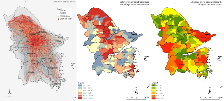
Town-level travel is characterized by a polycentric, high-density, and networked spatial structure (
Figure 2). Self-contained travel clusters have formed around the central urban area in the middle of the municipality, around Cixi and Yuyao in the north, and around Ninghai and Xiangshan in the south. Dense radial travel networks connect town centers with surrounding villages, and cross-township OD flows account for 52.86% of all town-level trips, indicating that town centers serve not only their own rural residents but also function as daily distribution hubs for neighboring villages. In terms of daily average trips, town-level travel displays a territory-wide high-value pattern: most townships across the municipality fall within the range of 500 to 5,000 trips per day, with low-value areas scattered only along the mountainous periphery. The average travel distance of town-level trips clusters within the 5 to 18 km range, suggesting that rural residents access town-level services at relatively low spatial cost.
Figure 2. Spatial distribution of town-level trip OD flows, daily average trips, and average travel distance.
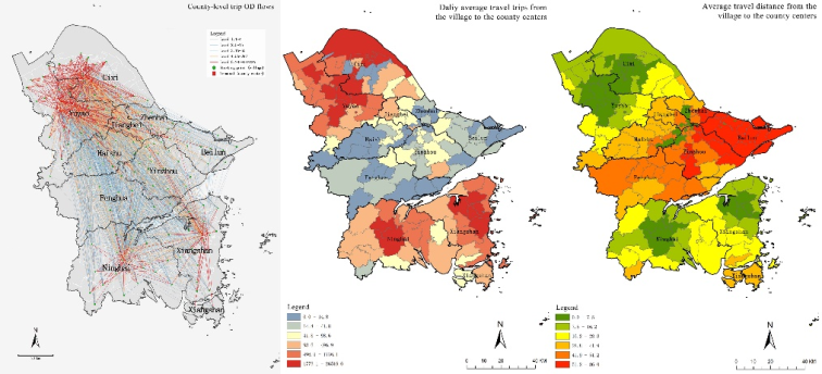
County-level travel exhibits a distinct core–periphery radial structure (
Figure 3). With county centers as cores, trip flows radiate outward, yet the overall OD flow density is far lower than that of town-level travel. Cross-county OD flows account for as much as 73.08%, indicating that the attractiveness of county centers has transcended administrative boundaries. In terms of daily average trips, county-level travel displays concentric decay centered on county centers: suburban townships (less than 10 km from the county centers) generally exceed 500 trips per day, with some surpassing 1,000; townships in the intermediate zone cluster in the 100 to 500 trips per day range; while remote townships at the county periphery (more than 30 km from the county centers) generally fall below 100 trips per day, and in townships such as those in eastern Beilun, western Haishu, and southern Fenghua, trips drop even below 15 per day. Regarding average travel distance, for villages within 10 km of the county centers, the distance is under 7.5 km; in the 10 to 25 km zone, distances cluster between 7.5 and 16 km; and for remote villages at the county periphery, distances generally exceed 30 km, with some areas surpassing 51 km. A cliff-like attenuation occurs at approximately 30 km from the county centers, a distance threshold that roughly corresponds to the effective service radius of county centers.
Figure 3. Spatial distribution of county-level trip OD flows, daily average trips, and average travel distance.
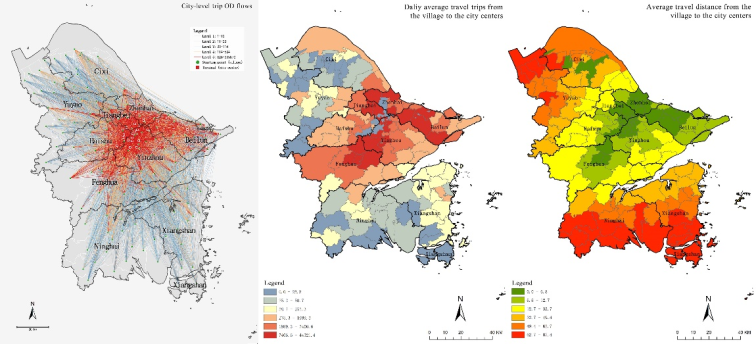
City-level travel exhibits a pronounced monocentric attraction pattern (
Figure 4). All OD linkages converge toward the central urban area in the middle of the municipality, forming a standard star-shaped structure. In terms of daily average trips, city-level travel shows a monocentric radiation with a long-tail distribution: townships within 20 km of the city center generally exceed 1,000 trips per day, with some suburban townships surpassing 7,400; in the 20 to 40 km intermediate zone, trips cluster between 200 and 1,000 per day; remote townships at 40 to 60 km remain at 25 to 275 trips per day; and outlying areas beyond 60 km still maintain a steady volume of 10 to 30 trips per day. As for average travel distance, city-level trips increase in concentric circles with the city center as the origin, rising gently within 30 km and accelerating sharply beyond that threshold. The key comparison is that in remote outlying areas, city-level trips (10 to 30 per day) are no fewer than, or even exceed, county-level trips (<15 per day), thereby forming a direct substitution of the city level for the county level.
Figure 4. Spatial distribution of city-level trip OD flows, daily average trips, and average travel distance.
4.2. Qualitative Results: Travel Decision-Making and Underlying Mechanisms
To explain the behavioral decisions and influencing mechanisms behind the weakening of county centers functions revealed by the quantitative analysis, four core themes were derived from the 30 interview transcripts: (1) social ties; (2) mismatches between perceived and objective accessibility; (3) hierarchical differentiation of travel needs; and (4) individual capability constraints.
4.2.1. Social Ties
The interviews revealed that in rural residents' high-order center travel, both intergenerational support within families and social interactions among neighbors and relatives are highly oriented toward city centers spatially, while county centers are scarcely factored into the travel considerations driven by these social ties.
On the one hand, intergenerational support directly binds rural residents to city-level resources. Multiple elderly respondents reported that when their children took them for medical treatment or family visits, the destinations were invariably city-level tertiary hospitals or the urban residential areas where their children had settled for work. A 67-year-old female villager stated, “When I'm not feeling well, my daughter takes time off or picks me up on weekends to see a doctor at the hospital in the city.” A 75-year-old female villager mentioned, “Once or twice a month I go to the city to visit my eldest son, see my grandson, and spend some time with him, or go to the hospital where my younger son works for a check-up.” Children not only provide transportation but also ease the elderly's anxiety in unfamiliar settings through companionship, helping them become familiar with bus routes and transfer nodes. Notably, only a few respondents mentioned their children working or living in the county centers. This indicates that quality employment opportunities and medical resources are concentrated in city centers, causing the natural orientation of intergenerational support to bypass county centers.
On the other hand, social interactions are likewise anchored in towns or city districts. Activities such as visiting relatives and friends, weddings, and funerals predominantly take place in nearby towns or the urban district. A 58-year-old female respondent said, “We have relatives living in the city. During Spring Festival, National Day, or for weddings and funerals, we drive there.” A middle-aged respondent added, “When a relative's child gets married, it's not appropriate to skip it; however far it is, you have to go. That's social obligation.” This sense of moral duty rooted in China's relational society renders long-distance trips to towns and city districts an unshirkable responsibility. Rural residents generally reported that their travel destinations were mostly in town centers or city centers, and they rarely, if ever, took the initiative to go to the county centers. Deprived of social intersections, the county centers were weakening. As a result, the logic of travel destination choice shifted from one driven by administrative hierarchy to one driven by social ties.
4.2.2. Mismatches between Perceived and Objective Accessibility
Quantitative data reveal that in townships physically closer to the county center than to the city center, rural residents' perceived accessibility of county-level and city-level travel runs counter to objective distance. This misalignment arises from differences in two types of services.
The first is the difference in accessibility of public transportation services. Long-distance buses to the city center usually offer easy transfer routes from the station to hospitals or business areas, causing minimal transfer anxiety. One respondent noted, “Public transportation in the city goes directly to hospitals and business districts, and the transfer is very fast and convenient.” By contrast, taking the bus to the county town often involves long waits and many stops at transfer hubs, which makes the trip take longer. Rural residents generally felt that although the county centers are closer in distance, having to change intercity buses makes the trip mentally exhausting; whereas the city centers, though farther, allows them to go straight to their destination where their children pick them up or where a faster metro connection is available, making it feel easier instead.
The second is the difference in the marginal utility of travel time. Rural residents commonly evaluate travel value by “how many things can be accomplished per unit of time.” For a comparable 1.5-hour trip, going to the county centers typically allows only one administrative task, such as taking a driving test or handling certificates, while a trip to the city center can combine medical visits, shopping, and family visits. A 31-year-old male villager said, “It takes about an hour and forty minutes to get to the city. I usually take my family there for medical treatment. Going to the county centers also takes around an hour. Sometimes I go there for errands or to visit relatives.” This psychological trade-off of “travel cost-effectiveness” leads the county center to be judged as “not worth it.”
4.2.3. Hierarchical Differentiation of Travel Needs
Quantitative analysis shows that county-level trips consist primarily of low-frequency, mandatory errands (e.g., license processing, purchasing goods), while city-level trips cover both inelastic needs (medical care) and elastic needs (leisure, family visits). The interviews reveal the mechanisms generating this divergence.
For inelastic needs, quality is prioritized, and distance is subordinated to service hierarchy. When it comes to irreplaceable needs such as medical treatment, rural residents' foremost consideration is service quality. Most rural residents believe that serious illnesses need to be treated at city-level hospitals, deeming county hospital doctor's incompetent and equipment outdated. Even with longer distances and waiting times, they still tend to choose city hospitals. In such cases, distance cost is substantially tolerated, and the county center is directly excluded for insufficient service quality. The service quality gap in critical domains such as healthcare and education further reinforces the rigidity of city-level trips.
For elastic needs, experience dominates, and perceived convenience determines travel willingness. Non-essential travel such as leisure, shopping, and dining out happens only when rural residents subjectively assess it as “convenient, not tiring, and worthwhile.” The urban district, with its concentrated commerce, direct bus connections, and abundant activities, is evaluated as “far but worth a visit”; the county centers, meanwhile, are actively avoided as “nothing to shop for and a hassle to get to.” A 49-year-old male worker stated, “When I have time off with nothing to do, I go to the city with a few buddies to hang out, or we just go to the town park for a while.”
4.2.4. Individual Capability Constraints
Rural residents of different ages, incomes, and health conditions, despite varied travel motives, exhibit highly convergent behavior: they reduce or forgo county-level trips. This is micro-level evidence of the weakening of county-level central functions.
Older adults skip the county centers as destinations directly due to physical constraints. The elderly are extremely sensitive to walking distances and transfers. An 81-year-old male farmer stated, “I usually take the bus when leaving the village. E-bikes are not safe, at our age, our hearing and eyesight are failing.” Getting to the county centers requires multiple transfers and long walks, considered physically demanding, whereas the direct bus to the city center allows them to “sleep on the bus and get off right at your destination,” a pattern much better suited to their physical condition.
Car-owning households, empowered by temporal autonomy, also bypass the county centers directly. A private car grants rural residents the freedom to compare service quality. Several respondents noted: “It's over an hour's drive to the city, but it doesn't feel very far,” and “Driving to the nearby town takes about 20 minutes, to the county centers about 40 minutes.” When the driving time difference between the city center and the county centers is within 30 minutes, they almost invariably choose the city.
5. Discussion
5.1. Triangulation: Quantitative and Qualitative Combination
This section triangulates the quantitative and the qualitative results from Section 4 to provide an integrated discussion of the key patterns and underlying mechanisms.
Table 3 summarizes the key quantitative patterns and their corresponding qualitative explanations. The analysis that follows proceeds along three dimensions: consistency, complementarity, and integrative inference.
Table 3. Joint Display of Quantitative Findings and Qualitative Explanations.
Quantitative findings | Qualitative explanations | Integrative inferences |
In remote townships, the daily average number of county-level trips falls below 15, and an attenuation occurs at a distance of 30 km from the county centers. | “There are more stops in the county center, and the waiting time is long.” “It takes almost an hour to get to the county centers, but only an hour and a half to the city centers.” | Low perceived accessibility leads to the voluntary bypassing of county centers. |
In remote townships, city-level trips remain at 10 to 30 per day, no lower than county-level trips. | “My son drives me to the city for medical treatment.” “Relatives all live in the city.” “I use public transport in the city centers, and the transfer waiting times are short.” | Social networks and time costs sustain city-level travel. |
County-level trips are low in frequency. | “I rarely come to the county centers, but I recently visited for a driving test.” “Apart from certificate processing, I never go to the county centers.” | County-level functions are concentrated in institutional affairs and lack scenarios embedded in daily life. |
5.1.1. Consistency Analysis
Quantitative and qualitative evidence exhibit a high degree of consistency in three respects. First, regarding the spatial decay of county-level trips, the quantitative analysis reveals an attenuation at 30 km from the county centers, with daily trips in remote townships falling below 15; in qualitative interviews, rural residents repeatedly stated that “going to the county centers requires transfers and a long wait” and “it takes an hour to the county centers, while the city takes only an hour and forty minutes.” Both sources of evidence point to low perceived accessibility as a primary driver of rural residents' abandonment of county centers. Second, concerning city-level travel in outlying areas, quantitative data show that even in townships over 60 km from the city center, city-level trips remain at 10 to 30 per day, no lower than or even exceeding county-level trips; interview narratives, such as “my son drives me to the city for medical treatment,” “relatives are all in the city,” and “I use public transport in the city centers, and the transfer waiting times are short”, provide dual support from social networks and time costs for this pattern. Third, this consistency indicates that the spatial pattern of “strong at the town and city levels, weak at the county level” revealed by quantitative analysis is not a random distribution but closely aligns with rural residents' travel decision-making logic.
5.1.2. Complementarity Analysis
Quantitative data cannot directly reveal the role of social ties, yet qualitative data offer crucial explanations for this. Quantitative data show that city-level trips remain stable in remote townships but cannot explain the source of this stability; interviews reveal that intergenerational support (children driving or accompanying elders for medical care) and interpersonal interactions (visiting relatives and friends, attending weddings and funerals) jointly pull city-level travel. This complementary finding indicates that the spatial orientation of social networks points toward towns or the urban district rather than the county centers, thereby shifting rural residents' destination choice from the logic of administrative hierarchy to the logic of social ties.
Similarly, quantitative data reveal low-frequency county-level trips but cannot explain why such business cannot be substituted by higher- or lower-level centers; interview responses such as “I rarely come to the county centers, but I recently visited for a driving test” and “apart from certificate processing, I never go to the county centers” suggest that county-level functions are concentrated in institutional affairs and lack scenarios embedded in daily life., and are thus chosen only when irreplaceable. This also constitutes the deeper reason why county-level trip volume is far lower than town-level and city-level volumes.
Furthermore, quantitative data show that in the hinterland of counties far from the city center, economically more developed townships exhibit exceptionally high town-level trip frequencies, yet cannot explain why town centers can accommodate such high trip volumes; interview accounts such as “20 minutes by e-bike to town is plenty” and “educational resources have all been merged into the town” indicate that town centers, through the concentration of basic service facilities (schools, markets, health clinics), have developed a strong capacity to absorb rural residents' daily needs, thereby partly substituting for the daily service function of county centers.
5.1.3. Triangulation Summary
Overall, quantitative and qualitative evidence exhibit high consistency on key conclusions such as county-level spatial decay and city-level substitution for county-level travel, with no substantive contradictions identified. Qualitative evidence provides four mechanisms that quantitative data cannot directly reveal for the quantitative patterns: social ties, the mismatch between perceived and objective accessibility, the hierarchical differentiation of travel needs, and rational choice under individual capability constraints. This consistency enables the study to conclude that the core mechanisms of county center weakening are the substitution effect of perceived accessibility for physical distance and the influence of social network on administrative hierarchy.
5.2. Extending Central Place Theory: A Contextualized Discussion
The integrative inferences above suggest that the “hierarchy–distance” trade-off principle of classic central place theory faces structural challenges in the contemporary Chinese rural context
| [27] | W. Christaller. Central Places in Southern Germany. Prentice Hall. Englewood Cliffs, N. J: Prentice-Hall; 1966, 230. |
[27]
. The core premise of classic central place theory, which holds that residents access services by first choosing the nearest lower-order center and moving to a higher-order center only when the lower-order one falls short, implicitly rests on two key assumptions: that service quality across centers of different orders increases continuously along the administrative hierarchy, and that residents' travel decisions are primarily constrained by physical distance and administrative tier. Our empirical findings, however, call for a contextualized revision of this premise.
Specifically, first, service quality does not increase continuously but is marked by a fault line. The county center's service quality in critical domains such as healthcare lags far behind that of the city center; rural residents perceive that “the county hospital is no good, only the city hospital works.” This quality gap prevents the county center from serving as a satisfactory intermediate option, shifting rural residents' travel choice from stepwise upward movement to leapfrog direct access. Second, perceived accessibility exerts a substitution effect on physical distance. When bus connections are complicated and transfer costs are high, the physically closer county center becomes subjectively “farther,” while the city center with direct transit becomes perceptually acceptable. Perceived time, rather than physical distance, emerges as the dominant variable in decision-making. Third, the social networks are misaligned with administrative hierarchy. Intergenerational support and interpersonal interactions are largely oriented toward city-level rather than county centers, forming a social gravity independent of administrative hierarchy. This implies that travel is not merely spatial movement but also a spatial practice of social relations. Fourth, town centers, by concentrating basic service facilities, have formed a stable local life sphere for rural residents' daily travel, effectively assuming part of the daily service functions originally expected of county centers and further squeezing the latter's existential space. These findings offer a contextualized revision of central place theory, revealing a structural misalignment between the institutional functions assigned by administrative hierarchy and residents' actual travel needs.
6. Conclusions
Drawing on mobile phone signaling data from Ningbo and semi-structured interviews with 30 rural residents, this study adopts a mixed-methods approach to reveal the spatial decay pattern of county-level trips and the underlying mechanisms on micro-level in China. We reveal the macro spatial pattern of rural travel through quantitative analysis, then elucidate the underlying mechanisms of rural residents' travel decision-making through qualitative analysis, and finally integrates both types of evidence in a joint discussion.
From the quantitative perspective, town-level travel is high-frequency, short-distance, and polycentric–networked; county-level travel decays in a core–periphery pattern, with an effective service radius of approximately 30 km and daily trips in remote townships falling below 15; city-level travel exhibits monocentric radiation while still maintaining 10 to 30 trips per day in outlying areas, with a total volume 2.5 times that of county-level travel. Although travel structures differ across townships in different geographic locations, the weakening of county center function in remote townships is a common feature. From a qualitative perspective, rural residents' decisions to forgo county centers and choose city centers are shaped by the interplay of social ties, mismatches between perceived and actual accessibility, hierarchical needs, and individual capability constraints. Travel decisions follow a logic of pursuing the highest service quality within acceptable cost. At the integrative level, quantitative and qualitative evidence corroborate each other, extending a contextualized understanding of central place theory. Service quality gaps, the substitution effect of perceived accessibility, social network dis-embedding, and the strong attraction of town-level daily services constitute the core mechanisms explaining why county centers are bypassed.
Policy recommendations are as follows. First, county center functions should be adjusted toward “specialized and precise” services, such as specialty medical care, integrated government service centers, and vocational education and training, to compete with city centers through differentiation. Second, transportation in remote townships needs to be optimized by establishing direct express corridors to the city center to reduce county-level transfers and deploy telemedicine and self-service government terminals. Third, social capital could be used by encouraging village committees to build mutual-aid travel networks and optimizing public transit with a focus on social scenarios (e.g., increased frequency on market days, special holiday family-visit lines). Finally, differentiated strategies need to be implemented for a variety of rural residents. For suburban townships, seamless urban integration is to be promoted. For economically developed townships in hinterland counties far from the city centers, their sub-center radiation capacity should be strengthened. For remote townships, it is necessary to advance a dual-track approach that guarantees basic services while establishing rapid linkages to higher-order centers.
This study has several limitations. The mobile phone signaling data covers only one month and thus cannot capture seasonal or festive fluctuations. The qualitative research is not a rigorous causal experiment, but rather enhances the depth of explanation through mechanism analysis. Its sample is confined to townships in Ningbo located in southeast China. The generalizability of the conclusions to other township types in central and western regions requires further validation. The signaling data cannot access deeper information such as trip purpose and travel mode, and reliance on a limited qualitative sample for supplementation may result in insufficient information coverage. Future research can conduct multi-regional comparisons to explore the evolution of county functions under different urbanization stages and topographic conditions. Moreover, longitudinal data or natural experiments could be employed to assess the dynamic impacts of urban-rural integration policy interventions.
Abbreviations
OD | Origin–Destination |
DaaS | Data as a Service |
Author Contributions
Jiayi Lin: Data curation, Formal Analysis, Investigation, Methodology, Validation, Visualization, Writing – original draft, Writing – review & editing
Conflicts of Interest
The author declares no conflicts of interest.
References
| [1] |
Pengjun Zhao, Zhao Yu, Yutian Jia. Shopping travel range and its determinants in rural towns of China. Economic Geography. 2019, 39(12), 70-79.
https://doi.org/10.15957/j.cnki.jjdl.2019.12.008
|
| [2] |
Zhengying Liu, Pengjun Zhao, Qiyang Liu, Zhangyuan He, Tingting Kang. Uncovering spatial and social gaps in rural mobility via mobile phone big data. Scientific Reports. 2023, 13(1), 64-69.
https://doi.org/10.1038/s41598-023-33123-0
|
| [3] |
Miaoxi Zhao, Ying Xu. Exploration of mobile signaling in village and town settlement network connections: A case study of three towns in Zhongshan. Shanghai Urban Planning. 2019, (06), 38-45.
|
| [4] |
Lin Tian, Yao Cheng, Xinyi Niu. Spatial organization of town and village areas in the network perspective: An analysis of resident cross-village travel links in Lin'an district, Hangzhou. Urban Planning Forum. 2023, (01), 104-110.
https://doi.org/10.16361/j.upf.202301015
|
| [5] |
Zhao Yu, Pengjun Zhao. The factors in residents’ mobility in rural towns of China: Car ownership, road infrastructure and public transport services. Journal of Transport Geography. 2021, 91:102950.
https://doi.org/10.1016/j.jtrangeo.2021.102950
|
| [6] |
Qiyang Liu, Zhengying Liu, Zhao Yu, Pengjun Zhao. The living environment and intravillage activity-travel: A conceptual framework based on participant observation in Guangdong, China. Journal of Rural Studies. 2023, 99, 121-133.
https://doi.org/10.1016/j.jrurstud.2023.03.006
|
| [7] |
Xiaoyan Huang, Yifan Xia, Chun Yin. Associations between the built environment and travel to higher-order centers in Chinese rural areas. Journal of Transport Geography. 2024, 119, 103956.
https://doi.org/10.1016/j.jtrangeo.2024.103956
|
| [8] |
Julian Hine, Md. Kamruzzaman, Neale Blair. Weekly activity-travel behaviour in rural northern Ireland: Differences by context and socio-demographic. Transportation. 2012, 39(1), 175-195.
https://doi.org/10.1007/s11116-011-9322-4
|
| [9] |
Hugh Millward, Jamie Spinney. Time use, travel behavior, and the rural–urban continuum: Results from the Halifax STAR project. Journal of Transport Geography. 2011, 19(1), 51-58.
https://doi.org/10.1016/j.jtrangeo.2009.12.005
|
| [10] |
Pengjun Zhao, Zhao Yu. Rural poverty and mobility in China: A national-level survey. Journal of Transport Geography. 2021, 93, 103083.
https://doi.org/10.1016/j.jtrangeo.2021.103083
|
| [11] |
Gina Porter, Kate Hampshire, Albert Abane, Augustine Tanle, Kobina Esia-Donkoh, Regina Obilie Amoako-Sakyi, Samuel Agblorti, Samuel Asiedu Owusu. Mobility, education and livelihood trajectories for young people in rural Ghana: A aender perspective. Children’s Geographies. 2011, 9(3-4), 395-410.
https://doi.org/10.1080/14733285.2011.590705
|
| [12] |
Gina Porter, Amleset Tewodros, Flavian Bifandimu, Mark Gorman, Amanda Heslop, Elisha Sibale, Abdul Awadh, Lorraine Kiswaga. Transport and mobility constraints in an aging population: health and livelihood implications in rural Tanzania. Journal of Transport Geography. 2013, 30, 161-169.
https://doi.org/10.1016/j.jtrangeo.2013.05.001
|
| [13] |
Zhao Yu, Peilin Li, Tim Schwanen, Pengjun Zhao, Zhifeng Zhao. Role of rural built environment in travel mode choice: Evidence from China. Transportation Research Part D: Transport and Environment. 2023, 117, 103649.
https://doi.org/10.1016/j.trd.2023.103649
|
| [14] |
Zihua Chen, Xiaowei Li, Bingzhi Liu, Shaohua Wang, Xiao Li, Jiaxin Li, Xiaohui Yang, Zhenbo Wang. Public transport accessibility in villages in and around major Chinese cities. Nature Cities. 2025, 2(8), 749-758.
https://doi.org/10.1038/s44284-025-00277-z
|
| [15] |
Jan Andersson, Gunilla Björklund, Henriette Wallén Warner, Katrin Lättman, Emeli Adell. The Complexity of Changes in Modal Choice: A Quasi-Experimental Study. Transportation Research Part F: Traffic Psychology and Behaviour. 2023, 96, 36-47.
https://doi.org/10.1016/j.trf.2023.05.015
|
| [16] |
J. M. Morris, P. L. Dumble, M. R. Wigan. Accessibility indicators for transport planning. Transportation Research Part A: General. 1979, 13(2), 91-109.
https://doi.org/10.1016/0191-2607(79)90012-8
|
| [17] |
Hisham Negm, Jonas De Vos, Felix Pot, Ahmed El-Geneidy. Perceived accessibility: A literature review. Journal of Transport Geography. 2025, 125, 104212.
https://doi.org/10.1016/j.jtrangeo.2025.104212
|
| [18] |
Jonas De Vos, Long Cheng, Yuerong Zhang, Kailai Wang, Milad Mehdizadeh, Mengqiu Cao. The effect of ease of travel on travel behaviour and perceived accessibility: A focus on travel to university campus. Transportation Research Part F: Traffic Psychology and Behaviour. 2025, 109, 1170-1181.
https://doi.org/10.1016/j.trf.2025.01.035
|
| [19] |
Jianping Zha, Liying Yan, Yuxuan Wang, Lamei He, Dandan Xu, Yu Yu. Demystifying intergenerational support from adult children in senior tourism consumption: Insights from large-scale household level survey data. Tourism Management Perspectives. 2025, 59, 101398.
https://doi.org/10.1016/j.tmp.2025.101398
|
| [20] |
Yan Li. Vehicle ownership, sustainable mobility and well-being in rural China. Environment, Development and Sustainability. 2023, 26(5), 12545-12568.
https://doi.org/10.1007/s10668-023-03890-x
|
| [21] |
Huijuan Li, Teng Hu, Xinyu Ma, Baodong Cheng. The impact of transportation infrastructure on the regional economic integration in China: A CGE analysis. International Review of Economics and Finance. 2025, 99, 104045.
https://doi.org/10.1016/j.iref.2025.104045
|
| [22] |
Yurun Wang, Pu Zhao, Senkai Xie Wenjia Zhang. Mesoscale structure in urban–rural mobility networks in the Pearl River Delta area: A weighted stochastic block modeling analysis. ISPRS International Journal of Geo-Information. 2023, 12(5), 183.
https://doi.org/10.3390/ijgi12050183
|
| [23] |
Weijing Wang, Sierra Espeland, Jesus M. Barajas, Dana Rowangould. Rural–nonrural divide in car access and unmet travel need in the United States. Transportation. 2025, 52(2), 507-536.
https://doi.org/10.1007/s11116-023-10429-6
|
| [24] |
Tao Tao, Petter Næss. Exploring nonlinear built environment effects on driving with a mixed-methods approach. Transportation Research Part D: Transport and Environment. 2022, 111, 103443.
https://doi.org/10.1016/j.trd.2022.103443
|
| [25] |
Anne Kerstin Reimers, Isabel Marzi, Franziska Beck, Eliane Engels, Denise Renninger, Adrian Buttazzoni, Claus Krieger, Yolanda Demetriou. Active travel behaviour in the family environment: Protocol for the mixed-methods cross-sectional ARRIVE study. BMJ Open. 2022, 12(2), e056383.
https://doi.org/10.1136/bmjopen-2021-056383
|
| [26] |
Jennifer C. Greene, Valerie J. Caracelli, Wendy F. Graham. Toward a conceptual framework for mixed-method evaluation designs. Educational Evaluation and Policy Analysis. 1989, 11(3), 255-274.
https://doi.org/10.3102/01623737011003255
|
| [27] |
W. Christaller. Central Places in Southern Germany. Prentice Hall. Englewood Cliffs, N. J: Prentice-Hall; 1966, 230.
|
Cite This Article
-
APA Style
Lin, J. (2026). Unveiling the “Weak Link”: Spatial Patterns and Mechanisms of County Central Functions Weakening in Ningbo Under Urban-Rural Integration. Urban and Regional Planning, 11(3), 152-163. https://doi.org/10.11648/j.urp.20261103.12
 Copy
|
Copy
|
 Download
ACS Style
Lin, J. Unveiling the “Weak Link”: Spatial Patterns and Mechanisms of County Central Functions Weakening in Ningbo Under Urban-Rural Integration. Urban Reg. Plan. 2026, 11(3), 152-163. doi: 10.11648/j.urp.20261103.12
Copy
|
Download
AMA Style
Lin J. Unveiling the “Weak Link”: Spatial Patterns and Mechanisms of County Central Functions Weakening in Ningbo Under Urban-Rural Integration. Urban Reg Plan. 2026;11(3):152-163. doi: 10.11648/j.urp.20261103.12
Copy
|
Download
-
@article{10.11648/j.urp.20261103.12,
  author = {Jiayi Lin},
  title = {Unveiling the “Weak Link”: Spatial Patterns and Mechanisms of County Central Functions Weakening in Ningbo Under Urban-Rural Integration},
  journal = {Urban and Regional Planning},
  volume = {11},
  number = {3},
  pages = {152-163},
  doi = {10.11648/j.urp.20261103.12},
  url = {https://doi.org/10.11648/j.urp.20261103.12},
  eprint = {https://article.sciencepublishinggroup.com/pdf/10.11648.j.urp.20261103.12},
  abstract = {Under the urban-rural integration strategy, county centers are assigned the pivotal role of bridging higher-level administrative units and lower-level towns and villages. However, rural residents' higher-order center travel increasingly bypasses county centers and goes directly to city centers, a hierarchical leap that contradicts the distance decay principle of central place theory. Drawing on mobile phone signaling data from Ningbo and semi-structured interviews with 30 rural residents, this study adopts a mixed-methods approach to reveal the spatial decay pattern of rural residents' county-level trips and the underlying mechanisms on micro-level in China. Quantitative analysis reveals that the daily number of county-level trips decays in a core–periphery concentric pattern. Findings show that in remote townships, more than 30 km from the county center, county-level trips fall below 15 per day, while city-level trips remain a stable substitute at 10 to 30 per day in these outlying areas. Qualitative analysis explains that the reasons rural residents bypass the county center include social ties, the mismatches between perceived and objective accessibility, the hierarchical differentiation of travel demands, and individual capability constraints. By triangulating quantitative and qualitative evidence, this study extends the understanding of administrative hierarchies and service access in central place theory under the context of Chinese urban-rural integration.},
 year = {2026}
}
Copy
|
Download
-
TY  - JOUR
T1  - Unveiling the “Weak Link”: Spatial Patterns and Mechanisms of County Central Functions Weakening in Ningbo Under Urban-Rural Integration
AU  - Jiayi Lin
Y1  - 2026/08/06
PY  - 2026
N1  - https://doi.org/10.11648/j.urp.20261103.12
DO  - 10.11648/j.urp.20261103.12
T2  - Urban and Regional Planning
JF  - Urban and Regional Planning
JO  - Urban and Regional Planning
SP  - 152
EP  - 163
PB  - Science Publishing Group
SN  - 2575-1697
UR  - https://doi.org/10.11648/j.urp.20261103.12
AB  - Under the urban-rural integration strategy, county centers are assigned the pivotal role of bridging higher-level administrative units and lower-level towns and villages. However, rural residents' higher-order center travel increasingly bypasses county centers and goes directly to city centers, a hierarchical leap that contradicts the distance decay principle of central place theory. Drawing on mobile phone signaling data from Ningbo and semi-structured interviews with 30 rural residents, this study adopts a mixed-methods approach to reveal the spatial decay pattern of rural residents' county-level trips and the underlying mechanisms on micro-level in China. Quantitative analysis reveals that the daily number of county-level trips decays in a core–periphery concentric pattern. Findings show that in remote townships, more than 30 km from the county center, county-level trips fall below 15 per day, while city-level trips remain a stable substitute at 10 to 30 per day in these outlying areas. Qualitative analysis explains that the reasons rural residents bypass the county center include social ties, the mismatches between perceived and objective accessibility, the hierarchical differentiation of travel demands, and individual capability constraints. By triangulating quantitative and qualitative evidence, this study extends the understanding of administrative hierarchies and service access in central place theory under the context of Chinese urban-rural integration.
VL  - 11
IS  - 3
ER  -
Copy
|
Download





 Share This Article
 Twitter
 Linked In
 Facebook