1. Introduction
Although the concerted efforts of the government, donor agencies, and other stakeholders to cope with the uncertainties in climate change indicators at the global level have yielded positive level of successes
| [1] | Umo, I. S., Okoroafor, P. E. N., and Ukwe, I. G. (2021). Climate variability and the issues in flood disaster risk awareness in Nigerian communities. NIPES Journal of Science and Technology Research, 3(4), 271–282.
https://doi.org/10.37933/nipes/3.4.2021.27 |
| [2] | Umo, I. S., Keke, I. C. & Enwereuzor A. I. (2026). Spatio-temporal models of maximum surface temperature in context of human comfort in Imo State ecological provinces. Alvan Journal of Social Sciences, 3(1), 682-692.
https://www-ajsspub-org.b12sites.com |
[1, 2]
, variations exist at both the regional and community levels as observed in Ezemonye et al
| [2] | Umo, I. S., Keke, I. C. & Enwereuzor A. I. (2026). Spatio-temporal models of maximum surface temperature in context of human comfort in Imo State ecological provinces. Alvan Journal of Social Sciences, 3(1), 682-692.
https://www-ajsspub-org.b12sites.com |
[2]
, Umo et al
| [3] | Ezemonye M. N., Ibanga, O. A., et al. (2025). The dynamics in rainfall and its implications on hunting livelihood in the littoral ecological zones of Niger Delta. Alvan Journal of Social Sciences, 2(3), 671-692. https://www-ajsspub-org.b12sites.com |
[3]
. The multiplier impacts of climate change-instigated uncertainties in rainfall cessations can alter farmland capability for optimum crop yield, food production, and food security. Such alteration had posed serious threats to food security in most local communities and regions, especially in the sub-Saharan African and Asian countries (Food and Agricultural Organization (FAO)
.
The uncertainty in rainfall cessation (i.e., anomalies), represents the deviations of annual rainfall from long-run averages, is an old and recurring challenge
| [5] | Pendergrass, A. G., Knutti, R., Lehner, F., Deser, C., & Sanderson, B. M. (2017). Precipitation variability increases in a warmer climate. Science Report 7, 17966. |
| [6] | Barbier, E. (2019). The Water Paradox: Overcoming the Global Crisis in Water Management. Yale University Press. |
[5, 6]
, usually with devastating impacts on crop yield per farmland, food production/ security; especially in the developing countries characterized by small farm-holdings and limited adaptive capacities
| [7] | Hall, J. W., et al. (2014). Water Security. Coping with the curse of freshwater variability. Science, 346, 429–430. |
[7]
. Within the developing countries, Zaveri, Russ & Damania
| [8] | Aryal, A., Maharjan, M., Talchabhadel, R., & Thapa, B. R. (2022). Characterizing meteorological droughts in Nepal: A comparative analysis of standardized precipitation index and rainfall anomaly index. Earth, 3, 409–432.
https://doi.org/10.3390/earth3010025 |
[8]
established that on the average ‘dry anomalies account for ~7.4 percent of global cropland expansion and 9 percent of cropland expansion in the developing world’. A two-stage assessment of the impact of rainfall-instigated uncertainties reveals that increase anomalies reduced crop productivities and a resultant increase in cropland expansion, with 1- to 2- and 3-y lags
| [8] | Aryal, A., Maharjan, M., Talchabhadel, R., & Thapa, B. R. (2022). Characterizing meteorological droughts in Nepal: A comparative analysis of standardized precipitation index and rainfall anomaly index. Earth, 3, 409–432.
https://doi.org/10.3390/earth3010025 |
[8]
.
Aryal, Maharjan, Talchabhadel, & Thapa
| [9] | Zaveri, E., Russ, J. & Damania, R. (2020). Rainfall anomalies are a significant driver of cropland expansion. Edited by Anthony J. Bebbington: PNAS Sustainability Science), 117(19), 10225 – 10233. Proceedings of the National Academy of Sciences, 2020.
https://www.pnas.org/cgi/doi/10.173/pnas.1910719117 |
[9]
observed that early rainfall cessation is associated with meteorological drought and it attendant effects of declining soil moisture and consequent crop failure without reference to surface water resources (agricultural drought). Empirical evidences have shown that uncertainties in rainfall cessation defined by precipitation deficiency constituted serious emerging dangers crops, water resources, economies, and human lives
| [10] | Kundu, A., Patel, N. R., Denis, D. M., Dutta, D. (2020). An estimation of hydro-meteorological drought stress over the central part of India using geo-information technology. Journal of Indian Society for Remote Sensing, 48, 1-9. |
[10]
across geographical regions over time scale. The prevalence of drought-induced early rainfall cessation is directly linked to deficit in soil moisture leading to force harvest of premature crops, poor crop output/ return per farmland, and increase food insecurity.
It has been observed that high variations in rainfall onset and cessation often cause discrepancies in interpreting seasonal characteristics, such as length of the rainy season, precipitation amount, and length dry days as envisioned in Ferijal, Batelaan, Shanafield, & Alfahmi
| [11] | Ferijal, T., Batelaan, O., Shanafield, M., & Alfahmi, F. (2022). Determination of rainy season onset and cessation based on a flexible driest period. Theoretical and Applied Climatology, 148, 91–104. https://doi.org/10.1007/s00704-021-03917-1 |
[11]
. Hence, distinct methods have been employed by researchers in determining rainfall onsets and cessations. The methods encompass the precipitation-based Agronomy method, which is an adaptive method as its parameters are locally adjustable with wide applications in Robertson
et al. | [12] | Robertson AW, Moron V, Swarinoto Y (2009). Seasonal predictability of daily rainfall statistics over Indramayu district, Indonesia. International Journal of Climatology, 29, 1449–1462. |
[12]
, and Moron
et al.
| [13] | Moron, V., A. W. Robertson, and M. N. Ward, 2006: Seasonal predictability and spatial coherence of rainfall characteristics in the tropical setting of Senegal. Mon. Wea. Rev., 134, 3248–3262. |
[13]
. A study succinctly enumerates three onset estimation methods as agronomy, anomalous accumulation, and a modified local method
| [11] | Ferijal, T., Batelaan, O., Shanafield, M., & Alfahmi, F. (2022). Determination of rainy season onset and cessation based on a flexible driest period. Theoretical and Applied Climatology, 148, 91–104. https://doi.org/10.1007/s00704-021-03917-1 |
[11]
, that is mostly used in climatological researches, yet applicability may differ due to the researcher’s interest or context.
Within the humid Tropics and Imo State in particular, a combination of agronomic method, backed by Harris et al
| [14] | Harris, I., Osborn, T. J., Jones, P. & Lister, D. (2020). Version 4 of the CRU/TS monthly high resolution gridded multivariate climate dataset. Data, 7 article 109. Retrieved online from
https://doi.org/10.1038/s41597-020-0453.3 |
[14]
geospatial resolution models can offer a more robustic avenue to generate data and used to predict crop specific growth, timing of yield, and mitigate adverse water shortage at the ecological level since the methods relied on local, seasonal, and annual rainfall data. The existing lacunas constitute major sources of concern, especially when considering the multitude and complex nature of phenomena modern physical geographers and allied earth scientific works by (Umo, Enwereuzor & Ezemonye
| [15] | Umo, I. S., Enwereuzor, A. I. and Ezemonye, M. N. (2021). Mathematical modelling of seasonal dynamics of bedload sediments in eco-geomorphologic units of humid tropical Rivers, Southeastern Nigeria. NIPES Journal of Science and Technology Research, 3(4), 259–270.
https://doi.org/10.37933/nipes/3.4.2021.26 |
[15]
, Mondal
| [16] | Mondal, P. (2014). A review study of eco-geomorphology an interdisciplinary approach to River science. Gideon Research Thoughts, 3(8), 1 – 7. |
[16]
, to clearly comprehend and elucidate their interactions for informed ecosystem service
| [15] | Umo, I. S., Enwereuzor, A. I. and Ezemonye, M. N. (2021). Mathematical modelling of seasonal dynamics of bedload sediments in eco-geomorphologic units of humid tropical Rivers, Southeastern Nigeria. NIPES Journal of Science and Technology Research, 3(4), 259–270.
https://doi.org/10.37933/nipes/3.4.2021.26 |
[15]
, demand valid descriptive statistical comparisons and appropriate inferential statistical modellings in space and time.
The activities of the bandits (unknown-gunmen) constitute one of the cardinal threats to rural farmer’s commitments to sustainable food production in Southern Nigeria. Also, increase in geophysical hazards such as meteorological droughts and extreme uncertainties in rainfall events reported in Umo
et al | [1] | Umo, I. S., Okoroafor, P. E. N., and Ukwe, I. G. (2021). Climate variability and the issues in flood disaster risk awareness in Nigerian communities. NIPES Journal of Science and Technology Research, 3(4), 271–282.
https://doi.org/10.37933/nipes/3.4.2021.27 |
| [2] | Umo, I. S., Keke, I. C. & Enwereuzor A. I. (2026). Spatio-temporal models of maximum surface temperature in context of human comfort in Imo State ecological provinces. Alvan Journal of Social Sciences, 3(1), 682-692.
https://www-ajsspub-org.b12sites.com |
[1, 2]
, Hubertus
et al | [17] | Hubertus, L., Groth, J., Teucher, M. & Hermans, K. Rainfall changes perceived by farmers and captured by meteorological data: Two sides to every story. Regional Environmental Change (2023) 23: 75, 1-15.
https://doi.org/10.1007/s10113-023-02064-9 |
[17]
, coupled with limited farmers’ awareness and drought-specific adaptation capacity at both community and farm level are expediting more devastating impacts on specific crop yield and food security in this Anthropocene Age due to the multiplier effects of climate change. The highlighted treatise collaborate diverse recent studies whose notions depict that the length of a given season naturally exhibits spatial and temporal variations due to shifts in onset and cessation’ as exemplified by Ferijal
et al | [11] | Ferijal, T., Batelaan, O., Shanafield, M., & Alfahmi, F. (2022). Determination of rainy season onset and cessation based on a flexible driest period. Theoretical and Applied Climatology, 148, 91–104. https://doi.org/10.1007/s00704-021-03917-1 |
[11]
Goswami and Xavier
| [18] | Goswami, B. N. & Xavier, P. K. (2005). ENSO control on the south Asian monsoon through the length of the rainy season. Geophysical Research Letter, 32, L18717. |
[18]
, Fu
et al | [19] | Fu, R., Yin, L., Li, W., Arias, P. A., Dickinson, R. E., Huang, L., Chakraborty, S., Fernandes, K., Liebmann, B., Fisher, R. & Myneni, R. B. (2013). Increased dry-season length over southern Amazonia in recent decades and its implication for future climate projection. Proceeding of the National Proceeding of the National Academy of Sciences, 110, 18110-18115. |
[19]
, Misra & DiNapoli
| [20] | Misra V, Dinapoli S (2014). The variability of the Southeast Asian summer monsoon. International Journal of Climatology, 34, 893 – 901. |
[20]
; Duru et al
| [21] | Duru, P. N., Umo, I. S. & Ojinma, C. C. (2015). Enhancing the capability of rural farmers towards effective soil management in Amucha community of Njaba, Imo State. Journal of Emerging Trends in Economics and Management Sciences, 6(8), 381-385. Retrieved online on 28/7/2025 from
https://doi.org/10.10520/EJC174483 |
[21]
; Marjuki
et al | [22] | Marjuki, Schrier G. V. D., Tank, A. M. G. K., Besselaar E. J. M. V. D., Nurhayati & Swarinoto, Y. S. (2016). Observed trends and variability in climate indices relevant for crop yields in Southeast Asia. Journal of Climatology, 29, 2651-2669. |
[22]
.
Geoscience and other scientific disciplines are seriously saddle with how it can best addressed vital global issues, such as climate change, food insecurity, human conflict, and persistent poverty
| [2] | Umo, I. S., Keke, I. C. & Enwereuzor A. I. (2026). Spatio-temporal models of maximum surface temperature in context of human comfort in Imo State ecological provinces. Alvan Journal of Social Sciences, 3(1), 682-692.
https://www-ajsspub-org.b12sites.com |
| [23] | World Science Forum. Declaration of the 10th World Science Forum on Science for Social Justice. 2022:
https://worldscienceforum.org/contents/draft-declaration-of-worldscience-forum-2022-is-now-open-for-comments-110144 |
| [24] | Stewart I, Capello M A, Mouri H, Mhopjeni K, Raji M. (2023). Three horizons for future geoscience. Earth Science System and Society, 3, 10079. Retrieved 2/3/2024 online from
https://doi.org/10.3389/esss.2023.10079 |
[2, 23, 24]
. Yet, current trends and directions in physical Geography researches (e.g. climate change, landforms, and food security) depict areal differentiations (from household, community, countries, regional, to global levels), due to dynamisms in stakeholders’ awareness, perception, responsive capacity, and adaptation
| [1] | Umo, I. S., Okoroafor, P. E. N., and Ukwe, I. G. (2021). Climate variability and the issues in flood disaster risk awareness in Nigerian communities. NIPES Journal of Science and Technology Research, 3(4), 271–282.
https://doi.org/10.37933/nipes/3.4.2021.27 |
[1]
. The cardinal issues of research interest in this context are highlighted thus: What are the underlying characteristics of annual rainfall cessations? Are there differences in annual trends of rainfall cessations over space-time? Do changes in geographical locations have statistically significant influence on rainfall cessation across the study agro-climatic zones? A clear elucidation of the issues will offer a better understanding of historical dimensions of how climate change-instigated uncertainties in rainfall cessations influence food production and security in the Imo agro-climatic zones.
The central purpose of this study is to examine the patterns in rainfall cessation from 1981 to 2023 (43 climatic years) and its implications on food security in Imo State agro-climatic zones of Nigeria. To achieve the stated central target, the following specific objectives were explored.
1) To identify and assess the characteristics of uncertainties in annual rainfall cessations among the three (Imo North, Imo East, and Imo West) agro- climatic zones.
2) To comparatively evaluate the space-time trends in rainfall cessations in the three agro- climatic zones of Imo State.
3) To determine whether of changes in geographic locations have statistically significant impacts on rainfall cessation across the agro-climatic zones in Imo State.
2. The Study Area
2.1. Location
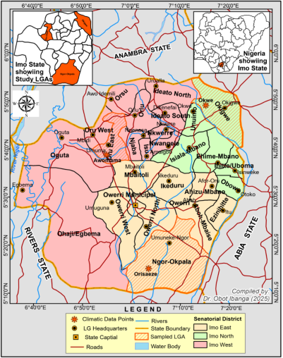
Imo State is situated between Longitudes 6° 5
1 and 7° 25
1 East of Greenwich Meridian and Latitudes 4° 5
1 and 7° 15
1 North of Equator. In context of relative geographical positions, Imo State share boundary with Anambra State on the East, Abia State on the West, and Rivers State on the South
| [2] | Umo, I. S., Keke, I. C. & Enwereuzor A. I. (2026). Spatio-temporal models of maximum surface temperature in context of human comfort in Imo State ecological provinces. Alvan Journal of Social Sciences, 3(1), 682-692.
https://www-ajsspub-org.b12sites.com |
[2]
as indicated in
Figure 1. Moreover, the State has an approximated total land mass of about 5,100 km
2, traverse by three agro-climatic zones (comprising Okigwe, Owerri, and Orlu).
2.2. Climate
The climate of the study area is generally classified as Af climate based on Köppen’s classification scheme cited in
| [1] | Umo, I. S., Okoroafor, P. E. N., and Ukwe, I. G. (2021). Climate variability and the issues in flood disaster risk awareness in Nigerian communities. NIPES Journal of Science and Technology Research, 3(4), 271–282.
https://doi.org/10.37933/nipes/3.4.2021.27 |
| [2] | Umo, I. S., Keke, I. C. & Enwereuzor A. I. (2026). Spatio-temporal models of maximum surface temperature in context of human comfort in Imo State ecological provinces. Alvan Journal of Social Sciences, 3(1), 682-692.
https://www-ajsspub-org.b12sites.com |
| [3] | Ezemonye M. N., Ibanga, O. A., et al. (2025). The dynamics in rainfall and its implications on hunting livelihood in the littoral ecological zones of Niger Delta. Alvan Journal of Social Sciences, 2(3), 671-692. https://www-ajsspub-org.b12sites.com |
[1-3]
. The dynamics in seasonality led to their stratifications into four dimensions, comprising long rainy, short rainy, long dry and short dry seasons observed in Umo
| [25] | Umo, I. S. (2019). The dynamics of sediments, heavy metals and nutrients in the Kwa Iboe River, southeastern Nigeria. Unpublished Ph.D. Thesis, Department of Geography and Regional Planning, University of Benin, Nigeria. |
| [26] | Umo I. S. (2025). An expanded synopsis on the dynamics of sediments, heavy metals, and nutrients in the Kwa Iboe River Basin, Nigeria. Alvan Journal of Social Sciences, 2(2), 1-15.
https://www-ajsspub-org.b12sites.com |
[25, 26]
. The degrees of dynamisms in climatic seasons usually exert divergent influences on rainfall onset and cessation across geographic space and time. The mean annual rainfall is over 2500 mm and a mean temperature of approximately 26.9
0 Celsius
| [27] | Umo, I. S. and Enwereuzor, A. I. (2021). The implications of area morphology and particulate matters’ distributions on the Kwa Iboe River Basin restoration, Southeastern Nigeria. Journal of Water Resources and Ocean Sciences, 10(3), 53 – 60. Retrieved on 20/4/2025 from
https://doi.org/10.11648/j.wros.20211003.13 |
[27]
. The relative humidity varies within the range of between 72 percent for dry season and 92 percent for rainy seasons
| [2] | Umo, I. S., Keke, I. C. & Enwereuzor A. I. (2026). Spatio-temporal models of maximum surface temperature in context of human comfort in Imo State ecological provinces. Alvan Journal of Social Sciences, 3(1), 682-692.
https://www-ajsspub-org.b12sites.com |
| [25] | Umo, I. S. (2019). The dynamics of sediments, heavy metals and nutrients in the Kwa Iboe River, southeastern Nigeria. Unpublished Ph.D. Thesis, Department of Geography and Regional Planning, University of Benin, Nigeria. |
[2, 25]
. Recently, there are marked evidences of rising temperature and rainfall in the area
| [2] | Umo, I. S., Keke, I. C. & Enwereuzor A. I. (2026). Spatio-temporal models of maximum surface temperature in context of human comfort in Imo State ecological provinces. Alvan Journal of Social Sciences, 3(1), 682-692.
https://www-ajsspub-org.b12sites.com |
[2]
due to the compounding effects global warming and climate variability.
Figure 1. Imo State Showing Agro-climatic Zones and Data Extraction Points.
2.3. Geology, Vegetation, and Land Use
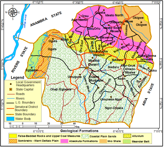
The geological formations of the studied Imo - climatic zones (
Figure 2), depict diversities over geomorphic spaces. The Imo Northern agro- climatic zone possesses five vital geological formations, comprising the False-bedded Rocks of Coal and Upper Measures, the Imo Shale, the Abeokuta formation, the Quaternary Alluvium, and the Coastal Plains Sands Deposits of Tertiary Times
| [2] | Umo, I. S., Keke, I. C. & Enwereuzor A. I. (2026). Spatio-temporal models of maximum surface temperature in context of human comfort in Imo State ecological provinces. Alvan Journal of Social Sciences, 3(1), 682-692.
https://www-ajsspub-org.b12sites.com |
| [29] | Onwumerobi, A. C. 2004. A synopsis of geomorphology. 2nd Edition. Owerri, CRC Publication. |
[2, 29]
. The dominant formations composed of the Imo Shale, occupying major parts of the Northern flank especially Okigwe and Onimo Local Government Areas, while the southern flank is a transitional zone with alternate formations of comprising dominantly Quaternary Alluvium region and traces of the Coastal Plains Sand Deposits of Tertiary Times
| [2] | Umo, I. S., Keke, I. C. & Enwereuzor A. I. (2026). Spatio-temporal models of maximum surface temperature in context of human comfort in Imo State ecological provinces. Alvan Journal of Social Sciences, 3(1), 682-692.
https://www-ajsspub-org.b12sites.com |
| [27] | Umo, I. S. and Enwereuzor, A. I. (2021). The implications of area morphology and particulate matters’ distributions on the Kwa Iboe River Basin restoration, Southeastern Nigeria. Journal of Water Resources and Ocean Sciences, 10(3), 53 – 60. Retrieved on 20/4/2025 from
https://doi.org/10.11648/j.wros.20211003.13 |
| [28] | Abeneme, A. O., et al. 2026. Space-time oscillations in rainfall onsets and implications on sustainable staple crop production in Imo State, Nigeria. Journal of Atmospheric Science Research, 9(2), 92 – 105. https://doi.org/10.30564/jasr.v9i2.13001 |
[2, 27, 28]
.
In context of geologic sequence of Age stratification as indicator, Onwumerobi
| [29] | Onwumerobi, A. C. 2004. A synopsis of geomorphology. 2nd Edition. Owerri, CRC Publication. |
[29]
identified the existent of the Paleocene, Eocene, Pleistocene formations in the Northern agro-climatic zone
| [2] | Umo, I. S., Keke, I. C. & Enwereuzor A. I. (2026). Spatio-temporal models of maximum surface temperature in context of human comfort in Imo State ecological provinces. Alvan Journal of Social Sciences, 3(1), 682-692.
https://www-ajsspub-org.b12sites.com |
[2]
. The complexities of geologic formations embedded in Imo North agro-climatic zone posed severe challenges to diverse engineering and allied construction works such as roads, bridges, and housing/ buildings. More so, the complexities in Geological formations coupled their complex sceneries (relief features) offer the soil diverse attributes that favour multiple agricultural practices such as unique rocky terrain that favours pastoral (animal) activities, multiple crop production such as tree crops (especially raffia, palm tree, pear, avocados, cashew, coconut, and orange), roots and tubers, plantain, and banana. Most recently the poor terrains in some areas within the Okigwe zone tend to offer sites criminal activities.
Figure 2. Imo State Showing the Geological Formations.
The Imo East agro-climatic zone is traverse dominantly by the Coastal Plains Sands Deposits of Tertiary Times, (occupying over 90 percent of the entire land areas), while the Quaternary Alluvium region occupies a residual land areas of less than 10 percent in the zone. The residual areas are prevalence in the transition zone between the Imo North and Imo East especially at the boundary region around Ikeduru, Mbaitoli, and Isiala Mbano axis of the Imo State (
Figure 2). The agricultural land uses have strong affinity with its soil and geological formations. The fairly uniform geological formation coupled with almost a homogenous flat-terrain offers the Imo East agro-climatic zone multiple options for diverse agricultural land uses, housing, industrial development, administration, and allied socio-economic activities.
The geological formations for the Imo West agro-climatic zone presented in
Figure 2 depict spatial dynamics, with shared attributes from the Imo North and Imo East agro-climatic zones. In addition, the existent of the unique Sombreiro, Meaner Belt, Coastal Alluvium, and the Coastal Plains Sand Deposits of Tertiary Times
| [2] | Umo, I. S., Keke, I. C. & Enwereuzor A. I. (2026). Spatio-temporal models of maximum surface temperature in context of human comfort in Imo State ecological provinces. Alvan Journal of Social Sciences, 3(1), 682-692.
https://www-ajsspub-org.b12sites.com |
[2]
provide agricultural and allied land users multi-dimensional options for sustainable production of crops such as roots and tubers (e.g. yam, cassava, potatoes, cocoyam, water yam), fruits and vegetables (corn, pumpkin, cucumber, pineapple), tree crops (e.g. palm tree, pearl, avocados, coconut, cashew, and cocoa).
3. Materials and Methodology
3.1. Research Design, Area Demarcation, and Sampling
This study is employed descriptive survey design to with a view to presenting the phenomenon of rainfall cessation in the three distinct agro-climatic zones in Imo State based on the secondary data. To explore the uncertainties in rainfall cessations, the study area was stratified into three major divisions using senatorial zones (Northern, Eastern, and Western) as index (as exemplified in
Figure 1 and their coordinates recorded as summarized in
Table 1 with the aid of using Germaine Global positioning System (GPS) as contextualized and applied in Umo et al
| [2] | Umo, I. S., Keke, I. C. & Enwereuzor A. I. (2026). Spatio-temporal models of maximum surface temperature in context of human comfort in Imo State ecological provinces. Alvan Journal of Social Sciences, 3(1), 682-692.
https://www-ajsspub-org.b12sites.com |
| [35] | Abaneme, A. O., Umo, I. S., Ukwe, I. G. & Ogu, C. (2025). Spatio-temporal fluctuations in rainfall during the growing seasons and its implication on sustainable agro-land use and practices in Imo State. Alvan Journal of Social Sciences, 2(2), 1 – 21. https://www-ajsspub2.org |
[2, 35]
.
The choices of locations for rainfall data extractions in each zone (stratum) were purposively selected to facilitate evenness in areal differentiations (i.e. temporal spread). The locational attributes of zone were primarily sourced though series of direct field studies (reconnaissance surveys) locations of (Longitudes and Latitudes) coordinates and determination of elevations.
3.2. Data Collection
On the contrary, data on rainfall cessations were extracted from the University of East Anglia Climatic Research Unit (Harris, Jones, Osborn, & Lister)
| [2] | Umo, I. S., Keke, I. C. & Enwereuzor A. I. (2026). Spatio-temporal models of maximum surface temperature in context of human comfort in Imo State ecological provinces. Alvan Journal of Social Sciences, 3(1), 682-692.
https://www-ajsspub-org.b12sites.com |
| [14] | Harris, I., Osborn, T. J., Jones, P. & Lister, D. (2020). Version 4 of the CRU/TS monthly high resolution gridded multivariate climate dataset. Data, 7 article 109. Retrieved online from
https://doi.org/10.1038/s41597-020-0453.3 |
| [28] | Abeneme, A. O., et al. 2026. Space-time oscillations in rainfall onsets and implications on sustainable staple crop production in Imo State, Nigeria. Journal of Atmospheric Science Research, 9(2), 92 – 105. https://doi.org/10.30564/jasr.v9i2.13001 |
[2, 14, 28]
, supported by CRU time series, version 4.05 of high resolution gridded data from January 1
st, 1981 to December 31
st, 2023 (43) climatic years using gridded method
| [2] | Umo, I. S., Keke, I. C. & Enwereuzor A. I. (2026). Spatio-temporal models of maximum surface temperature in context of human comfort in Imo State ecological provinces. Alvan Journal of Social Sciences, 3(1), 682-692.
https://www-ajsspub-org.b12sites.com |
| [28] | Abeneme, A. O., et al. 2026. Space-time oscillations in rainfall onsets and implications on sustainable staple crop production in Imo State, Nigeria. Journal of Atmospheric Science Research, 9(2), 92 – 105. https://doi.org/10.30564/jasr.v9i2.13001 |
| [35] | Abaneme, A. O., Umo, I. S., Ukwe, I. G. & Ogu, C. (2025). Spatio-temporal fluctuations in rainfall during the growing seasons and its implication on sustainable agro-land use and practices in Imo State. Alvan Journal of Social Sciences, 2(2), 1 – 21. https://www-ajsspub2.org |
[2, 28, 35]
. The gridded datasets were created with the grid cells’ specifications of 0.5° × 0.5° in size to extract periodic rainfall onset at three distinct geo-political zones in Imo State, Nigeria as applicable in Umo et al
| [2] | Umo, I. S., Keke, I. C. & Enwereuzor A. I. (2026). Spatio-temporal models of maximum surface temperature in context of human comfort in Imo State ecological provinces. Alvan Journal of Social Sciences, 3(1), 682-692.
https://www-ajsspub-org.b12sites.com |
| [28] | Abeneme, A. O., et al. 2026. Space-time oscillations in rainfall onsets and implications on sustainable staple crop production in Imo State, Nigeria. Journal of Atmospheric Science Research, 9(2), 92 – 105. https://doi.org/10.30564/jasr.v9i2.13001 |
[2, 28]
. The rationale was avert the constraints of fixed locational coverage embedded in rainfall data archival from distinct Nigerian Meteorological Agency (NiMet’s) weather stations within the State
| [2] | Umo, I. S., Keke, I. C. & Enwereuzor A. I. (2026). Spatio-temporal models of maximum surface temperature in context of human comfort in Imo State ecological provinces. Alvan Journal of Social Sciences, 3(1), 682-692.
https://www-ajsspub-org.b12sites.com |
| [3] | Ezemonye M. N., Ibanga, O. A., et al. (2025). The dynamics in rainfall and its implications on hunting livelihood in the littoral ecological zones of Niger Delta. Alvan Journal of Social Sciences, 2(3), 671-692. https://www-ajsspub-org.b12sites.com |
| [28] | Abeneme, A. O., et al. 2026. Space-time oscillations in rainfall onsets and implications on sustainable staple crop production in Imo State, Nigeria. Journal of Atmospheric Science Research, 9(2), 92 – 105. https://doi.org/10.30564/jasr.v9i2.13001 |
[2, 3, 28]
.
To ascertain the reliability test of the rainfall data sets from NiMet Station (at Imo Cargo Airport) and that of CRU from Eastern agro-climatic zone (Orisaeze) point were carried out using Cronbache’s test and the result attests very high level with a positive co-efficient of 0.97. It is worth emphasizing that the CRU raster data were collated monthly, with annual sum calculated using a raster calculator as demonstrated in recent researches such as Umo et al
| [2] | Umo, I. S., Keke, I. C. & Enwereuzor A. I. (2026). Spatio-temporal models of maximum surface temperature in context of human comfort in Imo State ecological provinces. Alvan Journal of Social Sciences, 3(1), 682-692.
https://www-ajsspub-org.b12sites.com |
[2]
, Abeneme et al
| [28] | Abeneme, A. O., et al. 2026. Space-time oscillations in rainfall onsets and implications on sustainable staple crop production in Imo State, Nigeria. Journal of Atmospheric Science Research, 9(2), 92 – 105. https://doi.org/10.30564/jasr.v9i2.13001 |
[28]
Okoro, Chen, Chineke & Nwofor
| [30] | Okoro UK, Chen W., Chieke C., & Nwofor 2014. Comparative analysis of gridded datasets and gauge k measurements of rainfall in the Niger Delta Regio. Research journal of Environmental Science, 8(7), 373-390.
https://doi.org/10.3923/rjes.2014.373.390 |
[30]
, Chen, Tian, Yao, & Ou
| [31] | Chen, D. L., Tian, Y. D., Yao, T. D., & Ou, T. H. (2016). Satellite measurements reveal strong anisotropy in spatial coherence of climate variations over the Tibet Plateau. Scientific Reports, Number 6, 484 – 504. |
[31]
, Omonigho
| [32] | Omonigho, G. M. (2022). A Comparative Analysis of Rural Livelihoods Vulnerability and Adaptation Strategies to Climate Change in the Mangrove Swamp and Freshwater Swamp Ecological Zones of Delta State, Nigeria. Unpublished PhD Synopsis, Department of Geography and Regional Planning, University of Benin. |
[32]
.
Table 1. Data Sources and Extraction Methods.
Agro-land Zones | Data Site Extraction | Longitudes | Latitudes | Elevation | Durations |
Eastern Agro-climatic Zone | Orisaeze | 7.0807 | 5.2728 | 62.51 meters | 1/1/1981 – 31/12/2023 |
Western Agro-climatic Zone | Awomama | 6.9331 | 5.6884 | 68.31 meters | 1/1/1981 – 31/12/2023 |
Northern Agro-climatic Zone | Okwe | 7.2186 | 5.7766 | 116.22 meters | 1/1/1981 – 31/12/2023 |
Source: Authors’ Compilation (2025).
3.3. Methods of Data Analysis
Data generated on the dynamics in rainfall cessation across the three agro-climatic zones were analyzed using descriptive and inferential statistical tools. The descriptive statistics encompasses mean, media, standard deviation, range, variance, and sum for comparative purposes and description of the phenomena of rainfall cessation. Further still, Time series with linear regression models were used in elucidating the annual trends, variances, and oscillations in rainfall cessation between 1981 – 2023 (43 climatic years), and compare the models between and among the agro-climatic zones in the Imo State for informed policy framework and decision making. On the basis of explainable variances and test of variability
4. Results and Discussions
The quantitative and thematic evaluations of uncertainties in the characteristics, trending patterns, and model predictive powers of rainfall cessations within and across diverse agro-climatic zones in Imo State are chronologically presented in the discourses that follow.
4.1. Assessments of Distributive Patterns in Rainfall Cessations in Imo State
The results of the distributive pattern of rainfall cessation at distinct agro-climatic zones of Imo State are descriptively summarized in
Table 2 for easy perusal and comparison. From the results, the minimum and maximum range for Imo West and Imo North maintains the homogenous values of 296.00 mm and 360.00 mm respectively, while the scenario in Imo North gives different values of 294.00 mm and 358.00 mm for minimum and maximum. A further exploration of the result using sum as index reveals differentiations. A highest sum of 13813.00 mm is recorded in Imo East, followed by a value of 13802.00 mm for Imo West, while a lowest sum of 13683.00 mm is associated with Imo North agro-climatic zone. The mean distributions indicate disparities based on geographic locations. Specifically, a highest mean score of 321.232mm is recorded in Imo East, followed by a value of 320.977 mm for Imo West, whereas a least mean score value of 318.209 occurs in Imo North agro-climatic zone.
To elucidate the pattern of discrepancies from the mean score, standard deviation is employed and the results in
Table 2 further reveal that a peak value of 13.898 is recorded at the Imo West agro-climatic zone, the value is closely followed by 13.815 mm for Imo East, while Imo North agro-climatic zone recorded a least standard deviation of 13.041 mm in the series. On the basis of variance, the results in
Table 2 clearly indicate that a highest value of 193.166 mm is obtained for Imo West, followed by 190.849 mm in Imo East while a lowest score value of 170.074 mm is associated with the Imo North agro- climatic zone of Imo State.
Table 2. Descriptive Analysis of the Uncertainties in Rainfall Cessations.
Location | N | Minimum | Maximum | Sum | Mean | Std. Deviation | Variance |
Imo_North | 43 | 294.00 | 358.00 | 13683.00 | 318.209 | 13.041 | 170.074 |
Imo_West | 43 | 296.00 | 360.00 | 13802.00 | 320.977 | 13.898 | 193.166 |
Imo_East | 43 | 296.00 | 360.00 | 13813.00 | 321.232 | 13.815 | 190.849 |
Source: Authors’ Analysis (2025).
The comparative assessment of the discrepancies in rainfall cessations across the agro- climatic zones and dates of occurrences as indicators, the results summarized in
Table 3 depict variations. From the results, the earliest rainfall cessation was recorded In Imo North agro-climatic zone on 21
st October, 1998, followed by the homogenous events on 22
nd October, 2008 recorded both at Imo East and Imo West agro-climatic zones respectively. In another dimension, Imo East and Imo West agro-climatic zones recorded a uniform late rainfall cessation date of 26
th December, 1990, while Imo North agro-climatic zone recorded a late rainfall cessation date on 12
th December, 1990. The marked deviations in rainfall early cessation and late cessation at the Imo North from other agro-climatic zones can partly be attributed to its exposure to and influence of the Guinea Savannah climate especially around the boundary of Okigwe in Imo State and Enugu State.
Table 3. Descriptive Analysis Characteristics of Rainfall Cessation in Imo State.
Agro-climatic Zones | Rainfall Data Points | Early cessation | Late cessation |
Imo North | Okwe | 21st Oct. 1998 | 12th Dec. 1990 |
Imo East | Orisaeze | 22nd Oct. 2008 | 26th Dec. 1990 |
Imo West | Awomama | 22nd Oct. 2008 | 26th Dec. 1990 |
Source: Data Analysis by the Researcher (2025).
4.2. Comparative Evaluations of Space-time Trends in Rainfall Cessations in Imo State
Time series with regression model were adopted as surrogate for determining the periodic trend in rainfall cessations across agro-climatic zones of Imo State and the results summarized in
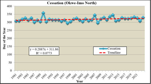
Figures 3, 4 and 5 indicate elements of consistency based on generalized positive trends and divergence based on the annual events. In the context of rainfall cessation in Imo North agro-climatic zone, the total positive anomalies of 15 climatic years is recorded and a total negative anomalies of 17 climatic years, while a total of 11 converges within the regression line.
On the basis of extreme events the results in presented in
Figure 3 reveals that a highest positive trend in cessation of 358 mm was recorded in 1998 climatic year, this is followed by 345 mm in 2013 climatic year. On contrary, a lowest cessation event of 294 mm is associated with the 1998 climatic year, accompanied by 295 mm for 2008 climatic year. A juxtaposition of the pattern exhibited in Imo North agro-climatic zone indicate the dominant negative convergence of annual rainfall cessation below the average regression value over the positive annual rainfall trends. Furthermore, though the annual anomalies sustain positive trends in the Imo North agro- climatic zone (
Figure 3), it very clear that the actual annual deviations from the average (regression) line are rather eclipsing due to the influence of climate change and local geography.
Figure 3. Temporal Trend of Rainfall Cessation in Okwe (Imo North).
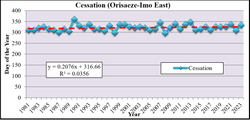
The results of the linearized model of rainfall cessation in Imo East agro-climatic zone presented in
Figure 4 depict variations in events and a positive trending pattern. In context of anomalies, the result reveals that a total of 13 climatic years trend above the average (regression) line, which suggest excess scenarios. Furthermore, a total of 14 climatic year trend below the average (regression) line, are the indicators of dominant of early cessation and a corresponding early cessation in optimum crop growth and yield, leading to premature harvest.
Contrarily, highest proportions of 16 climatic years were rather converging on the line of best fit in the Imo East agro-climatic zone of Imo State. The pattern in the uncertainties suggest possible adverse effects on crop production which Umo, Okoroafor, and Ukwe report that ‘farmers remain concerned about an increasing intensity of extreme weather events that will and has continued to occur as a result of climate variability’
| [1] | Umo, I. S., Okoroafor, P. E. N., and Ukwe, I. G. (2021). Climate variability and the issues in flood disaster risk awareness in Nigerian communities. NIPES Journal of Science and Technology Research, 3(4), 271–282.
https://doi.org/10.37933/nipes/3.4.2021.27 |
[1]
.
On the basis of extreme events, the results presented in Figure reveal that a most outstanding cessation in rainfall event of 360 mm is associated with 1990 climatic year, followed by 348 mm recorded in 2003 climatic year. A further juxtaposition of the results on the account of extreme events indicate that a least scenario of 296 mm is recorded in 2008 climatic year, and this closely followed by 297 mm recorded in 1998 climatic year of the Imo East agro-climatic zone. Moreover, the implication of focal convergent of rainfall cessation within the average is that the events sustain fairly uniform (normal) patterns in the series, partly due to the relative position of ITCZ that controls the two regional climate notably rainfall and temperature characteristics.
Figure 4. Temporal Trend of Rainfall Cessation in Imo East.
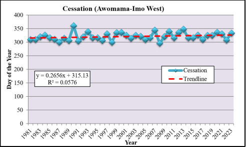
The linearized model of the cessation pattern in annual rainfall in Imo West agro-climatic zone is presented in
Figure 5 and the results differ based on climatic years. On the dimension of positive anomalies, the results show that the most dominant trend of 17 climatic years converge below the regression line while the total cessation periods of 15 climatic years exceeded the average line in the series. However, the residual cessation events of 11 climatic years fall within the average line in the series. The high incidences of early cessation in annual rainfall over other patterns can be attributed to increase in intervening influences of climate change impacts, deforestation and urbanization.
In the context of extreme cessation events, the results in
Figure 5 reveal that a highest amount of 360 mm is recorded in 1990 climatic year, followed by 348 mm for the 2013 climatic year. On the contrary, a least cessation amount of 296 mm is associated with the 2008 climatic year and this is accompanied by 300 mm recorded simultaneously during the 1987 and 1998 climatic tears, respectively. The high concentration of mean rainfall cessation amount on an around the regression line in the Imo West agro-climatic zone attests the homogenous nature the combine regional climatic stressors (especially anthropogenic and natural interventions) thereby constraining sustainability in annual and biannual crop yield as well as food security. This will become very eminent when juxtapose with the uproar in issues of internal insecurity and kidnapping cases that are threatening residents, farmers, and livelihoods in the region.
Figure 5. Temporal Trend of Rainfall Cessation in Awomama (Imo West).
To elucidate the predictive powers variations between of rainfall cessation and climatic years, regression model with time series were used and the results of the equation s are summarized in
Table 4 offer homogeneities and differences across the climatic years and agro-climatic zones. On the dimension of homogeneity, trending patterns uphold a unilateral positive increase across the distinct agro-climatic zones, while heterogeneities are observed annual trending values across the climatic years and the distinct agro-climatic zones in Imo State.
The Imo North agro-climatic zone exhibit a highest positive predictive value of 0.288x + 311.8 and a corresponding maximum positive regression co-efficient of 0.077 that explains 7.7 percent of the proportion of uncertainties in annual rainfall cessation in the sampled location. The implication of the result is that most of the uncertainties are driven by geographic space and climatic factor itself. The Imo West possesses closely related high positive predictive power with a linearized regression equation of 0.265x + 315.1 and a comparative low positive regression co-efficient of 0.057 that accounted for a total of 5.7 percent of the total proportion of uncertainties in rainfall cessation in the agro-climatic zone as evidence in
Table 4.
A further comparison based on findings from the Imo East agro-climatic zones depict marked disparities. Specifically, the linearized regression equation reveals a lowest predictive positive power of 0.207x + 316.6 and a corresponding least positive regression co-efficient of 0.035 that expressed a total of 3.5 percent of the proportion of uncertainties in annual rainfall cessation in Imo East agro-climatic zone. A generalized comparison of the results of the three agro-climatic zones led to a deduction that the leading positive predictive power and an affiliated dominant explainable variance in the regression co-efficient of rainfall cessation has strong affinity with the dynamics in relief and depletion of natural forest vegetation and land use types in Imo North agro-climatic zone. In context of literature, the results differ from Hubertus et al. whose study ‘shows the importance to analyze rainfall changes locally and seasonally as they are mainly perceived in how they affect agricultural activities’
| [17] | Hubertus, L., Groth, J., Teucher, M. & Hermans, K. Rainfall changes perceived by farmers and captured by meteorological data: Two sides to every story. Regional Environmental Change (2023) 23: 75, 1-15.
https://doi.org/10.1007/s10113-023-02064-9 |
[17]
. The observed difference is directly linked to the choice methods and locations.
Table 4. Analysis of Trend Patterns in Rainfall Cessation at Imo Agro-climatic Zones.
| Rainfall Data Points | Regression Equation | Regression Coefficient (R) | Pattern of Trend |
Northern | Okwe | y = 0.288x + 311.8 | 0.077 | Increasing |
Eastern | Orisaeze | y = 0.207x + 316.6 | 0.035 | Increasing |
Western | Awomama | y = 0.265x + 315.1 | 0.057 | Increasing |
Source: Authors’ Analysis (2025).
4.3. Evaluation of the Locational Impacts on Rainfall Cessations in Agro-climatic Zones
To elucidate the multiple proportion of explainable variance and test for variation in the impact geographic locations on uncertainties in rainfall cessation among three agro-climatic zones of Imo State, multiple linear regression, ANOVA, and T-test model were used and the results are presented in
Tables 5, 6 and 7 for easy perusal, comparison, and chronological assessments.
In
Table 5 the results of multiple regression models indicate that the regression co-efficient is 0.301 and the regression square of 0.090 while the standard error associated with the model is offers 0.82212. Dimensionally, the low positive regression co-efficient 0.301 implies that 3.01 percent of the impact of variations in geographic locations is attributed to the uncertainties in annual rainfall cessation in Imo State agro-climatic zones. In another perspective, the regression results suggests that uncertainties in rainfall cessation among the distinct agro-climatic zones can be better explain by factors such as spatial spread, relief, vegetation, but accelerated by multi-purpose land uses and abuses as triggered by urbanization as envisaged in Umo
et al. | [28] | Abeneme, A. O., et al. 2026. Space-time oscillations in rainfall onsets and implications on sustainable staple crop production in Imo State, Nigeria. Journal of Atmospheric Science Research, 9(2), 92 – 105. https://doi.org/10.30564/jasr.v9i2.13001 |
[28]
, Montgomery
| [33] | Montgomery, C. W. (2003). Environmental geology. 6th edition. Boston, McGraw Hill. |
[33]
, Ackerman and Knox
| [34] | Ackerman, S. A. and Knox, J. A. (2003). Meteorology: Understanding the atmosphere. United State, Thomson Book/Cole. |
[34]
.
Table 5. Regression Analysis of Multiple Impacts of Locations on Rainfall Cessations.
Model | R | R Square | Adjusted R Square | Std. Error of the Estimate |
1 | 0.301a | 0.090 | 0.020 | 0.82212 |
a. Predictors: (Constant), Cess_Imo_West, Cess_Imo_North, Cess_Imo_East
To test for the multiple effect of impact of variations in geographic location on the combination of uncertainties in rainfall cessation among the three distinct agro-climatic zones, ANOVA model was employed and the results summarized in
Table 6 reveal that the sum of squares associated with the model is 2.617 while the sum of squares of the residual offers 26.359.
Furthermore, the mean square of regression gives 0.872 while the mean square of residual reveals a value of 0.676 in the series. When the model was subjected to statistical test, the result gives a calculated low positive ANOVA value of 1.291 that is statistical insignificance at 0.05 confidence level. The results contradicted Umo and Enwereuzor
| [27] | Umo, I. S. and Enwereuzor, A. I. (2021). The implications of area morphology and particulate matters’ distributions on the Kwa Iboe River Basin restoration, Southeastern Nigeria. Journal of Water Resources and Ocean Sciences, 10(3), 53 – 60. Retrieved on 20/4/2025 from
https://doi.org/10.11648/j.wros.20211003.13 |
[27]
report in the wetland area of Kwa Iboe River whose pattern maintained statistical significant variations. It is therefore inferred from the result that of dynamics in geographic locations have no statistically significant impacts in uncertainties in rainfall cessation among the agro-climatic zones.
Table 6. ANOVAa Model of Impact of Location on Annual Rainfall Cessations in Imo State.
Model | Sum of Squares | df | Mean Square | F | Sig. |
1 | Regression | 2.617 | 3 | 0.872 | 1.291 | 0.291b |
Residual | 26.359 | 39 | 0.676 | | |
Total | 28.977 | 42 | | | |
a. Dependent Variable: Geographic Location.
b. Predictors: (Constant), Cess_Imo_West, Cess_Imo_North, Cess_Imo_East
Discounting the results in the multiple models presented in
Tables 5 and 6, partial regression model and T-test statistics were employed. The model results of rainfall cessations for Imo North, Imo East, and Imo West summarized in
Table 7 reveal that the standardized partial regression co-efficient of 0.129, 0.870, and -0.945 respectively. The logical comparison of the results show that the highest proportion of variance associated partial regression model of -0.945 is recorded in the Imo West agro-climatic zone, followed by a high positive value of 0.870 in the Imo East, while the least value of 0.129 is accrue to the Imo North agro-climatic zone. Indeed, Umo, Okoroafor & Ukwe whose work the promotion of sustainable development and creation of ecological smart future with limited or zero flood disaster risk is useful in this regard
| [1] | Umo, I. S., Okoroafor, P. E. N., and Ukwe, I. G. (2021). Climate variability and the issues in flood disaster risk awareness in Nigerian communities. NIPES Journal of Science and Technology Research, 3(4), 271–282.
https://doi.org/10.37933/nipes/3.4.2021.27 |
[1]
. However, such actions demand developing, working, and sustaining preliminary ecological disaster plans blueprint whose principles, methods, and applications in Nigerian environment need be people-society friendly is necessary in this context
| [1] | Umo, I. S., Okoroafor, P. E. N., and Ukwe, I. G. (2021). Climate variability and the issues in flood disaster risk awareness in Nigerian communities. NIPES Journal of Science and Technology Research, 3(4), 271–282.
https://doi.org/10.37933/nipes/3.4.2021.27 |
[1]
.
Table 7. Partial Regression and T- Test of Variations between Parameters in Imo State.
Model | Unstandardized Coefficients | Standardized Coefficients | t | Sig. |
B | Std. Error | Beta |
1 | (Constant) | 0.698 | 3.212 | | 0.217 | 0.829 |
Cess_Imo_North | 0.008 | 0.017 | 0.129 | 0.476 | 0.637 |
Cess_Imo_East | 0.052 | 0.028 | 0.870 | 1.895 | 0.066 |
Cess_Imo_West | -0.056 | 0.030 | -0.945 | -1.866 | 0.070 |
a. Dependent Variable: Location
On the contrary, the T-test models of the level of significance summarized in
Table 7 indicate a unilateral statistically insignificant impact between the dependent and independent variables at 0.05 confidence level. The finding led to a deduction that there is no statistically significant impact of uncertainties between geographical location and rainfall cessation in each agro-climatic zone of Imo State. The result collaborates Abaneme
et al. whose study on fluxes in rainfall during length of growing established statistical insignificant locational effect
| [35] | Abaneme, A. O., Umo, I. S., Ukwe, I. G. & Ogu, C. (2025). Spatio-temporal fluctuations in rainfall during the growing seasons and its implication on sustainable agro-land use and practices in Imo State. Alvan Journal of Social Sciences, 2(2), 1 – 21. https://www-ajsspub2.org |
[35]
.





 Share This Article
 Twitter
 Linked In
 Facebook
 Copy
Copy Download